@pathandfocus retweeted
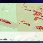
Last week, #California had some extreme fire activity. Here is the #BridgeFire and the #LineFire hotspots animated over the most active days.
Explore for yourself: lens.pathandfocus.com/?endDa…
@pathandfocus retweeted
Wanna see something cool? We (@calebissharp) built a fire simulation model... in Rust... and it's blazing fast... also it outputs ASCII (for fun).
This dynamically pulls weather data, topography, fuel, runs a 12h burn period producing a 18,700ha fire all in 6 seconds.
#wildfire
@pathandfocus retweeted
Looking at #wildfire data often requires that you know exactly when a fire took place. It doesn't help you interact with or explore unfamiliar data.
Mother Nature just doesn't care about the fact that it's Saturday. 🗓️
Let's break down how we can do better. 🧵
@pathandfocus retweeted
We're adding historic @CWFIS hotspot data to lens.pathandfocus.com and have noticed that the estimated size leans a particular way in certain regions at certain times of the year. E.g. in S.E. USA the est size is larger in later months. Anyone have ideas why?
@pathandfocus retweeted
Lens is a map of Canadian wildfire data created by @pathandfocus + @twostoryrobot
Explore wildfires interactively by date and area - built with a static set of pmtiles archives
lens.pathandfocus.com
@pwramsey might find it interesting!
@pathandfocus retweeted
I often describe fire growth as a series of "sprints". It's not a steady jog, but rather large amounts of growth occurring in short timeframes.
@twostoryrobot's hot spot tool provides a great visual representation of this with the count of spots per day.
@pathandfocus retweeted
Last week, a cold front passed through the province following several days of hot, dry weather.
@pathandfocus retweeted
We're experimenting with visualizing all the hotspot data at once. In case you were wondering what #Yellowknife is facing right now, here's all hotspots this year (grey) with the last 3 days in yellow, orange, and red. Scary stuff. Stay safe up there friends.
@pathandfocus retweeted
Let me introduce you to a new term I’ve started using… “tactical recreation”
#wildfire in BC is now just a part of life, and we have to adapt.
Keep a bag of gear ready and monitor air quality regularly. If it’s green nearby, bug out to breath some clean outside air.
@pathandfocus retweeted
This one is the best of the afternoon. Really fluid stuff! It looks like it just kinda erupts. #wildfire #bcwildfire #kamloops
@pathandfocus retweeted
Scary weekend with that #osoyoosfire. It took only a matter of hours for it to grow substantially and threaten hundreds of homes.
lens.pathandfocus.com/?zoom=…
@pathandfocus retweeted
We've been working on adding evac alert/order boundaries to Lens (our experimental mapping tool). While the WMS tile layers are convenient, we'd prefer the polygon data. Also, we're noticing the gov service is giving errors frequently (probably lots of demand).

ALT Screenshot of prototype changes to Lens, our experimental wildfire mapping tool. Evacuation alert and order boundaries from TNRD shown in yellow and red shapes. Dots showing hotspot data progression in yellow, orange, and red as the Ross Moore Lake fire burns towards Kamloops from July 22 to July 24 2023.
@pathandfocus retweeted
I spent the weekend playing with the #bcwildfire @BCGovFireInfo #wx data.
It’s a bit cumbersome but not impossible.
Here is a quick guide on how you can download this weather data for yourself, merge all the files into one, and filter it to just show noon data.
🧵