Soil sampling season is underway!🪣
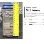
Here are some simple but important questions. Can you answer all of them?
Check out our latest blog to learn why they matter and find helpful soil sampling resources for Arkansas producers.
arkansascrops.uada.edu/posts… – at Jonesboro, AR
These past two days, I learned a lot about what makes Delta soils in Arkansas unique🌾
I had the opportunity to attend the annual meeting of the Arkansas Association of Professional Soil Classifiers.
Thanks for having me and for the opportunity to share some of my work! – at Jonesboro, AR
Our soybean P trial in Faulkner Co. is wrapping up. Thanks @faulkneruada for your work!
We're evaluating two P sources (TSP and DAP), rates (45 and 90 lb P₂O₅/ac), and a split application (planting and R1).
Given this year's weather, I'm interested in seeing the results🌱 – at Bay, AR
Harvested the soybean phosphorus trial this afternoon. I have collected the plants and will send them to @a_mosmith at the @AginArk Northeast Reaearch Center to thrash and get yield. The potassium trial is next. @AR_Extension @AgWriterArk @UARK_SoilTest
Ana Morales-Ona Smith retweeted
A sharper view of our changing planet is coming. 🛰️🌎
Meet LandIS, the Landsat Instrument Suite that will fly aboard Landsat 10, the next satellite in the Landsat series.
With 26 spectral bands spanning visible light to thermal infrared, LandIS will collect more than twice as many bands as Landsat 8 and Landsat 9. These additional bands will help users better distinguish features on Earth’s surface and monitor water quality, agriculture, vegetation health, snow and ice, soil conditions, and other environmental parameters.
LandIS will also capture finer spatial detail, with resolutions of 10 to 20 meters for visible, near-infrared, and shortwave-infrared observations. That means a clearer view of smaller features, including streams, streamside habitats, woodlots, and individual agricultural fields.
Together, more spectral bands and finer spatial resolution will help users detect, distinguish, and track environmental change with greater detail and precision.
Expected to begin operations in the early 2030s, LandIS will also continue Landsat’s coverage of sunlit land and near-shore waters, along with select nighttime observations. It will also uphold the program’s high standards for data accuracy, extending a record of Earth observations that spans more than 54 years.
Learn more about Landsat 10 and its planned capabilities: ow.ly/X4gK50ZW4EE
📷: A visual comparison of spatial resolution showing the 30-meter pixels of Landsat 8 and 9 (left) alongside the finer, more detailed 10-meter pixels planned for Landsat 10 (right). Credit: NASA
Soil-test values can change depending on when you collect samples, with some nutrients showing greater changes than others.
This will be a great demo to see those changes and explore how they affect fertilizer recommendations!
Thanks @faulkneruada for your support with this! – at Jonesboro, AR
Working with Dr. @a_mosmith on a soil sampling project. I established soil sampling plots in two different soil types in a soybean field in Lollie. I will collect samples from the same plots over the next few months. @AginArk @AR_Extension @AgWriterArk @UARK_SoilTest
Ana Morales-Ona Smith retweeted
Arkansas Rice Update 9-25-26
arkansascrops.uada.edu/posts…
New rice pathologist, bacterial panicle blight, futures, harvest progress, 2027 decisions, & ARC/PLC sign ups.
Ana Morales-Ona Smith retweeted
🚨 New from The Kernel Lab! 🌽
Can narrower rows help when pushing seeding rates?
20-in (51-cm) rows enhanced yield at 3 of 4 site-years, and the response to seeding rate was more pronounced under narrow spacing at two site-years.
🔗sciencedirect.com/science/ar…
Ana Morales-Ona Smith retweeted
Recently had several calls/emails asking about the outcome of some planted undies. It really got me thinking about what a cool teaching tool it is, and how its also been maybe over used at times. Well those thoughts made it into a blog. Check it out. osunpk.com/2026/09/17/soil-y…
Ana Morales-Ona Smith retweeted
Arkansas Rice Update 9-11-26
arkansascrops.uada.edu/posts…
Prelim results of ARPT, harvest progress, supply/demand, & markets.
Ana Morales-Ona Smith retweeted
You can now explore the entire US with 1-meter 3D LiDAR data!
I rebuilt my USGS elevation viewer so you can search any address, zoom all the way into the terrain, and slide between LiDAR and satellite imagery.
The detail is incredible. You can pick out riverbeds, ridgelines, old roads, drainage patterns, and terrain completely hidden by trees.
Try it here and export your own animated GIF: mattmullin.space/state-lidar
Happy exploring!
Readers added context they thought people might want to know
The linked app visualizes USGS 3DEP as Art series maps based on ~10 m resolution DEMs, not 1 m LiDAR. Nationwide 1 m seamless DEM coverage is still in progress and incomplete.
usgs.gov/3d-elevation-p…
mattmullin.space/state-lidar
Ana Morales-Ona Smith retweeted
Arkansas harvest progress for week ending 9/6
Corn 🌽 80% v 54% avg
Rice 🌾 53% v 31% avg
Soybeans 🌱 27% v 11% avg (record pace for the week).
Source: USDA NASS
Ana Morales-Ona Smith retweeted
Arkansas Rice Update 9-4-26
arkansascrops.uada.edu/posts…
Preliminary planting date yields, harvest progress, & markets.
Special day 🌾🚜
My first-ever rice field project in Arkansas was harvested today. First of many 🙏
Now to work with the spatial yield data and the sensor data collected throughout the season to see what we learn.
Thanks, Nick, Justin, and their crews for all the help! – at Bay, AR
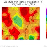
Much of Arkansas received below-normal precipitation during August. With soil sampling approaching, there are a few things to keep in mind when sampling under dry conditions.
We summarized a few of those considerations in this blog: arkansascrops.uada.edu/posts… – at Arkansas, USA
Ana Morales-Ona Smith retweeted
While Ana Morales-Ona Smith's work focuses on collecting information about crop conditions, research led by Jason Davis and Terry Spurlock is examining how drones can act on that information. Read more: aaes.uada.edu/news/sensor-te… @a_mosmith @DavisSprayGuy @SpurlockLab @AginArk @ArkansasEPP @uarkbumpers @NEArkRice
Ana Morales-Ona Smith retweeted
Arkansas Rice Update 8-28-26
arkansascrops.uada.edu/posts…
Harvest progress, futures, & diesel.
We were collecting coordinates from our high-N reference plots ⛳️
We’ll find those same spots in our drone, commercial, and satellite imagery and see how closely the values compare across the season🛰️
Thanks, @jenrae_martin, for your support with this, and for capturing my first-ever picture with an Arkansan frog! 🐸😅 – at Bay, AR
Ana Morales-Ona Smith retweeted
🚨🚨 Calling all Indiana Farmers, Consultants, and Advisors. Please help us out and take a minute to fill out this short survey to help quantify recent rainfall and flooding impacts on crops in the state. Please share also.
@PurdueAg @PurdueExtension
extension.entm.purdue.edu/ne…
Ana Morales-Ona Smith retweeted
Arkansas Rice Update 8-21-26
arkansascrops.uada.edu/posts…
Harvest progress, harvest loss behind combine, herbicide-resistant weed screening, & markets.
Ana Morales-Ona Smith retweeted
One of the biggest opportunities in precision agriculture may already be available at no cost. Read about @AginArk research comparing satellite images with those from drones and handheld device readings, as well as fungicide spray drone research on #rice @NEArkRice: aaes.uada.edu/news/sensor-te… @a_mosmith @DavisSprayGuy @SpurlockLab @ArkansasEPP @uarkbumpers @AR_Extension