

Award-winning TV/digital meteorologist⛈ CBM seal #767📃 Living the Island life🏝 @StonyBrookU Alum🐺 Proud dad x2👨👦 Music lover🎵 Mediocre athlete⚾
Long Island, NY
Joined March 2010
- Tweets23.8K
- Following1.8K
- Followers3.8K
- Likes18.9K






Geoff Bansen retweeted

Today's project- super high resolution topography of Long Island revealing glacial landforms.

So is this the #Yankees lineup next year?
1. Lombard SS
2. Judge RF
3. Rice 1B/DH
4. Stanton DH
5. Bellinger LF
6. Volpe 2B
7. Jones CF
8. Wells C
9. Caballero 3B


Geoff Bansen retweeted

El Niño communication is an absolute mess.
For example:
- Some are showing Daily Niño values
- Some are showing Weekly Niño values
- Some are showing Monthly Niño values
- Some are showing 3-Month Niño values
- Some are using Coral Reef Watch values
- Some are showing RONI
- Some are showing ONI
- Some are showing Niño 1+2
- Some are showing Niño 3.4
- Some are showing temperatures in Fahrenheit
- Some are showing temperatures in Celsius
- Some are showing anomolies in Fahrenheit
- Some are showing anomolies in Celsius
El Niño communication feels like the Wild Wild West, we've got datasets and numbers all over the place. We need to find a way to tighten things up.
NOAA changed its primary operational metric earlier this year, why is that not getting used more? The switch to RONI (Relative Oceanic Niño Index) was made because the traditional ONI was becoming increasingly problematic in a warming ocean. NOAA wanted an ENSO index that better represented the temperature contrast across the Pacific.
With that said, using the new official RONI metric from NOAA, you'll see this El Niño is not the strongest...yet. Since 1950, that goes to the 1982/1983 El Niño event. If trends continue, however, the current El Niño will beat it later this Fall into early Winter. Stay tuned...


I can understand people along the water saying underhyped and people far from the shore saying overhyped. But this kinda falls in line with what I've been saying all week.

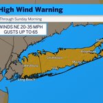
NWS has upgraded Long Island to a High Wind Warning. The sustained wind range is the same, but they have upped the gusts from 55 to 65. These will come overnight into Sunday morning.


Maybe because they have their attention on Fay and Gonzalo thousands of miles across the Atlantic, but I am pretty shocked that the NHC did not so much as give the coastal storm a small numerical chance. There was always a chance for warm core characteristics with this thing.
An absolute clown headline 🤦♂️

Monster hurricane baffles experts as 'spaghetti model' shows beast barrelling toward several US states, what happens if it hits California? trib.al/dERJzrG

Readers added context they thought people might want to know
National Hurricane Center forecasts state Polo's center will remain offshore Mexico without US landfall, with guidance steering it away despite model spread; experts are tracking it normally, not baffled, and no models show it barrelling toward California as a threat.
nhc.noaa.gov/text/MIATCDEP2…
nytimes.com/2026/09/23/wea…
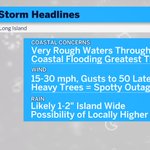
Storm will continue to wobble, be a little unpredictable. Cast that aside, here is all you need to know right now.

Mid-Atlantic will get pounded by this storm. We are now starting to get coastal flood advisories on the South Shore.


Timing for rain from coastal storm will be Friday night through Sunday. East end gets highest amounts more than likely.

