OpenStreetBrowser retweeted
Joie : OpenStreetMap et copains avec ses surprises utiles pour les défis exigeants que nous aimerions relever.
OpenStreetBrowser affiche les cheminements piétons + trottoirs rendant intelligible & visuelle (photos) la qualité de la contribution (ici l'accessibilité handicapés).
The new "Kerbs" category shows kerbs (the edge where a road meets a sidewalk).
More about this here: community.openstreetmap.org/…
OpenStreetBrowser retweeted
The beautiful visualization of the recently imported Sidewalks that were generated with #OSM_SidewalKreator (and carefully validated with aerial imagery) on the new category at @opstreetbrowser , thanks @weeklyOSM for the good news!!
The new "Kerbs" category shows kerbs (the edge where a road meets a sidewalk).
More about this here: community.openstreetmap.org/…
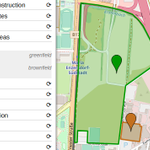
OpenStreetBrowser: The new "Footways" category (under Transportation -> Walking) shows sidewalks, footways, steps, platforms and pedestrian zones. openstreetbrowser.org/#categ…
More: blog.openstreetbrowser.org/n…
#OpenStreetMap #OSM
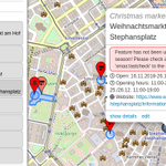
The christmas season is coming, and with it all those christmas trees and markets! It's time to check, if the map in your area is up-to-date. Use the Christmas category on OpenStreetBrowser to check if all xmas features are mapped correctly! #OpenStreetMap
openstreetbrowser.org/#categ…

ALT Screenshot of OpenStreetBrowser showing the Christmas category. On the left you have a list of features, on the right the map with a few markers. One of the features has a popup, where a warning is displayed: "Feature has not been updated for the current season! Please check and set the tag 'xmas:lastcheck' to the current date."
OpenStreetBrowser retweeted
Ļoti jaukā #OpenStreetMap datu pārlūkā jauna funkcionalitāte.
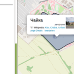
Piem., var aplūkot, kādi Vikipēdijas raksti saistīti ar objektiem kādā vietā.
Tas ietver detalizētu informāciju, ieskaitot "operator" tagu.
openstreetbrowser.org/#map=1…
#OpenStreetBrowser: New "Quality Control" categories:
Fix Me, Culture - Media/Wikidata, Wikipedia
openstreetmap.org/user/skunk…
#OpenStreetMap #OSM
OpenStreetBrowser retweeted
Ce site en ligne basé sur de la donnée OSM vient d’ouvrir une nouvelle catégorie « qualité » et permet de visualiser les objets nécessitant intervention (fixme) et valorisant les interliens avec la fondation Wikimedia (wikidata, Wikipedia…).
#OSMquality
#OpenStreetBrowser: New "Quality Control" categories:
Fix Me, Culture - Media/Wikidata, Wikipedia
openstreetmap.org/user/skunk…
#OpenStreetMap #OSM
#OpenStreetBrowser: New "Quality Control" categories:
Fix Me, Culture - Media/Wikidata, Wikipedia
openstreetmap.org/user/skunk…
#OpenStreetMap #OSM
OpenStreetBrowser has an exciting new feature! "Custom categories", which can be edited from within the interface. Just click on '+' and 'create custom category'.
Please share links to your custom categories as replies!
#OpenStreetMap #OSM
Check out the tutorial:
github.com/plepe/OpenStreetB…
Translating is possible here: weblate.openstreetbrowser.or…
The video is also available on Youtube: youtu.be/I0x4Kwz6u90
OpenStreetBrowser retweeted
Check out the tutorial:
github.com/plepe/OpenStreetB…
Translating is possible here: weblate.openstreetbrowser.or…
The video is also available on Youtube: youtu.be/I0x4Kwz6u90
OpenStreetBrowser retweeted
We are now an official local chapter for the geographical region of Austria!The document was signed during #SotM2022.Thanks to the OSMF for accepting us as a local chapter!😀Don't forget,the next Austrian onlineMeetup is on 14.09.2022 wiki.openstreetmap.org/wiki/… #osm @FOSSGIS_Verein
Writing categories for #OpenStreetBrowser has gotten much easier, as they can be written using YAML. I created a short tutorial: github.com/plepe/OpenStreetB…
I'm looking forward to your own categories! Also, comments about the tutorial are highly appreciated. #OSM #OpenStreetMap
OpenStreetBrowser retweeted
I wrote a module for #OpenStreetMap web maps using the #LeafletJS API: With github.com/plepe/leaflet-ove… you can query map items around the mouse pointer:
youtube.com/watch?v=JTzVa9E0…
OpenStreetBrowser retweeted
Ich hab ein Tool geschrieben, das hilft, Einträge verschiedener OGD Datensätze (dzt. nur @Stadt_Wien) mit #Wikidata, #Wikipedia, #WikimediaCommons und #OpenStreetMap abzugleichen. Hier ein #Screencast dazu: youtube.com/watch?v=e9Is-3ss…
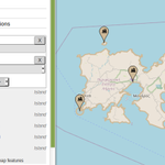
The "Natural Formations" category in OpenStreetBrowser now includes islands and islets!
openstreetbrowser.org/#map=1…
#openstreetmap #osm
OpenStreetBrowser retweeted
Replying to @omengue @FabSintes
OpenStreetBrowser retweeted
My blog post about mapping artwork and memorials for #OpenStreetMap with #Wikimedia (Wikidata, Commons) integration: openstreetmap.org/user/skunk… #OSM
Hope to see more artwork and memorials soon!