

A native iOS weather toolkit to fit any need. Radar, models, satellite, soundings, and much more.
Joined June 2025
- Tweets191
- Following125
- Followers80
- Likes581





Echoes Weather retweeted

830 PM CDT Friday Oct 9 Update: Isaias makes landfall near Destin, Florida with maximum winds near 105 mph. Follow the latest on #Isaias at hurricanes.gov


TD9 has formed in the Gulf, and is expected to become the first Atlantic hurricane of the year. Landfall expected somewhere between New Orleans and the Western part of the Florida panhandle. Monitor local forecasts and the official NWS forecast.
Echoes Weather retweeted

🌪️ BREAKING: Francis Peak tornado rated EF2 with 120 mph winds
The National Weather Service has completed its damage survey of the September 18 tornado that tore through the Davis and Morgan County mountains, and the numbers are impressive.
🌪️ Rating: EF2
💨 Estimated peak wind: 120 mph
📏 Path length: 5.93 miles
↔️ Maximum width: 1,900 yards (1.1 miles) — a new Utah state record for tornado width
⏱️ Time on the ground: 16 minutes
📈 Total elevation change: 6,700 feet
🏔️ Highest elevation: About 9,500 feet
🌲 Fatalities: 0
🏥 Injuries: 0
The tornado touched down around 1:44 PM near Bair Canyon, about 6,000 feet in elevation, before climbing up toward Francis Peak.
As it crossed the summit into Morgan County, it snapped numerous pine trees at higher elevations before turning northeast toward Middle Smith Lake, where some of the most significant damage occurred. Numerous trees were either snapped at the base or completely sheared off near the top.
The tornado then descended toward Dalton Creek, where it expanded to an incredible 1.1 miles wide. Aspen groves were flattened and numerous mature pine trees were snapped.
Some of the damaged pines are estimated to be 100–200 years old. 🌲
The tornado eventually weakened and dissipated near Peterson around 2 PM after traveling nearly six miles through some of the most rugged terrain in Utah.
This was a legitimate EF2 tornado in the Utah mountains, and the combination of its strength, size, elevation change and terrain makes this an extraordinary storm.
The NWS says the information is still preliminary and could change following final review.

The Francis Peak tornado has been rated an EF2 with 120mph winds. It was on the ground for nearly 6 miles, and was over a mile wide! That is something I never thought I’d type for a tornado that reached over 9000 feet in elevation.

🌪️ BREAKING: Francis Peak tornado rated EF2 with 120 mph winds
The National Weather Service has completed its damage survey of the September 18 tornado that tore through the Davis and Morgan County mountains, and the numbers are impressive.
🌪️ Rating: EF2
💨 Estimated peak wind: 120 mph
📏 Path length: 5.93 miles
↔️ Maximum width: 1,900 yards (1.1 miles) — a new Utah state record for tornado width
⏱️ Time on the ground: 16 minutes
📈 Total elevation change: 6,700 feet
🏔️ Highest elevation: About 9,500 feet
🌲 Fatalities: 0
🏥 Injuries: 0
The tornado touched down around 1:44 PM near Bair Canyon, about 6,000 feet in elevation, before climbing up toward Francis Peak.
As it crossed the summit into Morgan County, it snapped numerous pine trees at higher elevations before turning northeast toward Middle Smith Lake, where some of the most significant damage occurred. Numerous trees were either snapped at the base or completely sheared off near the top.
The tornado then descended toward Dalton Creek, where it expanded to an incredible 1.1 miles wide. Aspen groves were flattened and numerous mature pine trees were snapped.
Some of the damaged pines are estimated to be 100–200 years old. 🌲
The tornado eventually weakened and dissipated near Peterson around 2 PM after traveling nearly six miles through some of the most rugged terrain in Utah.
This was a legitimate EF2 tornado in the Utah mountains, and the combination of its strength, size, elevation change and terrain makes this an extraordinary storm.
The NWS says the information is still preliminary and could change following final review.
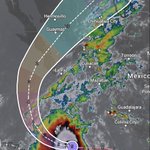
Hurricane Polo remains a strong category 5 hurricane in the Pacific. It is expected to make landfall in the Southern Baja California region of Mexico as a category 2 storm.


Tropical Storm watches up for parts of the Mexican coast from Colola to Tetitlán. Tropical Storm Polo is expected to undergo rapid intensification over the next 24 to 48 hours, eventually becoming a category 4 hurricane.
Expect heavy rains in mountainous regions.
——————————————————
La tormenta tropical vigila partes de la costa mexicana desde Colola hasta Tetitlán. Se espera que la tormenta tropical Polo experimente una rápida intensificación en las próximas 24 a 48 horas, convirtiéndose eventualmente en un huracán de categoría 4.
Espere fuertes lluvias en regiones montañosas.

@NWSSaltLakeCity @SLCScanner Tornado damage from the Middle Smith Lake, UT area. Road completely blocked. A couple people trying to clear the road, but not enough resources at this time.


This was 10 miles in a car, 1.5 on a four-wheeler, and another ~1.5 of walking. The damage in the video is taken at ~ 8920ft. True alpine tornado. Next time someone says “tornados don’t go up mountains…”, remember this!

@NWSSaltLakeCity @SLCScanner Tornado damage from the Middle Smith Lake, UT area. Road completely blocked. A couple people trying to clear the road, but not enough resources at this time.
RT @ChaseThomason: 🌪️ NEW VIDEO: TORNADO TOUCHES DOWN IN DAVIS COUNTY
This tornado touched down in the foothills of Davis County Friday af…
Echoes Weather retweeted

A funnel cloud has been observed with this storm over northern Davis county! Please reply to this post with any pictures or other observations of hazards with this storm (we'll be monitoring), as X notifications appear to be down as of this writing. #utwx

Tornado Warning including Layton UT, Kaysville UT and Farmington UT until 2:15 PM MDT

ALT This graphic displays a tornado warning plotted on a map. The warning is in effect until 2:15 PM MDT. The warning includes Layton UT, Kaysville UT and Farmington UT. This warning is for South central Weber County in northern Utah, Northeastern Davis County in northern Utah and West central Morgan County in northern Utah. The threats associated with this warning are a radar indicated tornado and ping pong sized hail. There are 133,614 people in the warning along with 49 schools and 0 hospitals.
On this date in 2004:
Hurricane Ivan struck the Gulf Coast as a powerful category 3 hurricane.
It caused close to 20 billion USD worth of damage in the United States alone, and claimed 124 lives in the Caribbean and US combined.

Hurricane Lowell has reached category 5 strength and is expected to turn North and stay to the West of Hawaii over the next few days.
Max sustained winds: 160mph
Min pressure: 922mb