

Weather Specialist at 11 pm from Toronto to the Maritimes.
Peterborough
Joined October 2010
- Tweets4.6K
- Following950
- Followers2.4K
- Likes2.5K




Caley Bedore retweeted

Models have low tracking south meaning more snow but uncertainty on warm pocket of air which could bring temps above freezing by Thur. a.m. reducing amounts for shores of Lake ON - Euro (left) vs NAM (right). 15-25 cm still poss. for Toronto/20-40 cm north of the city. #onstorm


Caley Bedore retweeted

New snow squall watches are up for late Tuesday and Wednesday. Winds will switch back to the southwest bringing the heaviest squalls into some areas that have yet to be hit like Kington, PEC and parts of Niagara. #onstorm


Did you get a photo of the northern lights last night? Post it in a reply below and I might feature it on the news this evening. I'll start...

Caley Bedore retweeted

Update 6:20 PM EDT Thurs: Helene now an extremely dangerous Category 4 hurricane
A NOAA Hurricane Hunter aircraft currently investigating Helene recently found that the maximum sustained winds have increased to 130 mph (215 km/h). The minimum central pressure has also decreased to 947 mb (27.96 inches) based on dropsonde data.

Caley Bedore retweeted
Computer models are in agreement that a very mild second half of September is shaping up for central and eastern Canada.


Here we go. Get ready for some serious rainfall through Friday.

Rainfall warnings due to flood risk eastern Ontario & southern Quebec Fri. to early Sat. a.m. due to Tropical Storm Debby remnants. 50 to locally 100+mm poss. according to some models. Heavy downpours (poss. flooding) with t-storms for GTHA later tonight into Fri. a.m. #onstorm


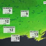
A big temperature change for the region tonight, with some single digit overnight lows expected for Haliburton and Bancroft areas.

Caley Bedore retweeted

Monster shelf with a huge lowering just moved onshore right over me.
Dundonald, Ontario
#onstorm #onwx #shareyourweather
@stormhour @caleybedore @IWeatherON @ECCCWeatherON

We are working with a lot of moisture today! Watching for heavy localized downpours this afternoon and evening.
Very humid today with plenty of available moisture for storms that do form this afternoon in southern Ontario and the GTHA. Torrential downpours a concern with possible flooding. #onstorm
Caley Bedore retweeted

NTP investigation, including a ground/drone survey, has confirmed an EF1 tornado near Perth, ON on July 24. Damage to structures and trees was reported at properties from the Christie Lake area to S of Rideau Ferry ending near Jasper.
Details: uwo.ca/ntp/blog/2024/ef1_tor…
#ONstorm

Caley Bedore retweeted
A Geomagnetic Storm Watch (G3 Strong) has been issued by NOAA's Space Weather Prediction Centre. Weather depending, that means the aurora may be visible tonight farther south than usual in Canada and the U.S. #Auroraborealis

Caley Bedore retweeted
20-40mm of rain fell in an hour this afternoon causing localized flooding in some areas of Toronto.
Caley Bedore retweeted
After 3 hours of chasing in the Peterborough area and seeing nothing, this was waiting for me when I got home.
Dundonald, Ontario
#onstorm #onwx #shareyourweather
@caleybedore @KMacTWN @ECCCWeatherON @StormHour

Caley Bedore retweeted

View of #onstorm cell around noon as it heads East of Bobcaygeon towards Buckhorn / Burleigh Falls.
Cell developed nice hail core after is passed town.
@IWeatherON @ChrisScottWx @weathernetwork @WxOntario1 @StormhunterTWN @AlannahFranks @caleybedore @kawarthanow @Ptbo_Canada

Tornado Warning now in effect for Bancroft area.
Environment Canada meteorologists are tracking a severe thunderstorm that is possibly producing a tornado.
Damaging winds, hail and intense rainfall are also possible.
In effect for: Bancroft - Hastings Highlands - Denbigh
An advancing cold front is triggering severe storms across the region this afternoon and evening.
Threats include torrential rain, strong wind, hail and a possible tornado.

