

Former On Air Tv Meteorologist Now NWS Meteorologist & Rutgers University Alum Rower/Long Distance Runner.
- Tweets34.8K
- Following3.8K
- Followers3.3K
- Likes18.2K













ALT High temperatures in the 90s to low 100s will make for a significant heat wave across the central and eastern U.S. beginning on Sunday and lasting through next week. These hot temperatures combined with high humidity will lead to heat indices of 100-110 degrees, and locally as high as 115. Low temperatures only dropping into the 70s will provide little overnight relief. Multiple days of Major to Extreme HeatRisk are forecast across the Mississippi and Ohio Valleys next week. These levels of heat mean health impacts become more likely in general, and may occur in ANYONE without adequate hydration or cooling. High or moderate extreme heat risks cover much of the U.S. east of the Rockies July 4-5, with a broader slight risk through July 7 extending as far west as the Great Basin. Heat indices of 100-110 degrees are possible, and warm nights in the 70s-80s may limit relief over the holiday weekend. Stay informed and take steps to protect yourself from heat related illnesses.

ALT This graphic displays Severe Thunderstorm watch number 317 plotted on a map. The watch is in effect until 12:00 AM EDT. The watch includes parts of Delaware, Maryland, New Jersey, New York, Pennsylvania and Virginia. The threats associated with this watch are no tornadoes expected, isolated hail up to quarter size possible and scattered gusts up to 65 mph possible. There are 27,572,039 people in the watch along with 6473 schools and 372 hospitals.

ALT This graphic displays a severe thunderstorm warning plotted on a map. The warning is in effect until 8:00 PM EDT. The warning includes Centreville VA, Oakton VA and Fair Oaks VA. This warning is for South central Loudoun County in northern Virginia, The western City of Fairfax in northern Virginia, West central Fairfax County in northern Virginia, The northern City of Manassas Park in northern Virginia, Northwestern Prince William County in northern Virginia and The north central City of Manassas in northern Virginia. The threats associated with this warning are wind gusts up to 70 MPH and pea sized hail. There are 330,109 people in the warning along with 56 schools and 2 hospitals.

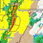
ALT This graphic displays Severe Thunderstorm watch number 234 plotted on a map. The watch is in effect until 8:00 PM EDT. The watch includes parts of District of Columbia, Maryland, Pennsylvania, Virginia and West Virginia. The threats associated with this watch are no tornadoes expected, isolated hail up to quarter size possible and scattered gusts up to 70 mph likely. There are 12,043,651 people in the watch along with 2909 schools and 145 hospitals.







ALT This graphic displays a tornado warning plotted on a map. The warning is in effect until 7:15 PM EDT. The warning includes Pine Orchard MD and Woodstock MD. This warning is for South central Carroll County in north central Maryland, Northwestern Howard County in central Maryland and North central Montgomery County in central Maryland. The threats associated with this warning are a radar indicated tornado and pea sized hail. There are 43,488 people in the warning along with 12 schools and 0 hospitals.

ALT This graphic displays a severe thunderstorm warning plotted on a map. The warning is in effect until 7:15 PM EDT. The warning includes Westminster MD, Hampstead MD and Manchester MD. This warning is for Northern Carroll County in north central Maryland and East central Frederick County in north central Maryland. The threats associated with this warning are wind gusts up to 60 MPH and pea sized hail. There are 91,151 people in the warning along with 29 schools and 1 hospital.

ALT This graphic displays a tornado warning plotted on a map. The warning is in effect until 7:15 PM EDT. The warning includes Westminster MD, New Windsor MD and Union Bridge MD. This warning is for Central Carroll County in north central Maryland and East central Frederick County in north central Maryland. The threats associated with this warning are a radar indicated tornado and no hail is expected. There are 53,739 people in the warning along with 20 schools and 1 hospital.