






☀️ A BEAUTIFUL STRETCH OF WEATHER AHEAD!
High pressure is firmly in control across the region this afternoon, bringing us plenty of sunshine and pleasant temperatures.
And the good news? The quiet weather pattern is sticking around! High pressure will remain in place throughout the week, keeping skies sunny to mostly sunny and conditions dry across the region for the next several day and potentially even beyond! #INwx #ILwx #OHwx #MIwx #WIwx

MILD, DRY & SUNNY WEATHER AHEAD ☀️
High pressure will continue to dominate the weather pattern across the Midwest this week, bringing plenty of sunshine and dry conditions to the region.
As high pressure strengthens, temperatures will run above normal through much of the week and into the weekend. Overall, it looks like a quiet stretch of weather with mild temperatures, sunny skies, and very little precipitation expected.
#INwx #ILwx #OHwx #MIwx #WIwx

❄️ NOAA 2026–27 WINTER OUTLOOK
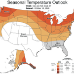
The Climate Prediction Center (CPC) has released its 2026–27 Winter Outlook, providing an early look at what the upcoming winter could bring.
The outlook calls for above-average temperatures across the northern and much of the eastern United States, including the Midwest.
For precipitation, below-normal precipitation is favored across portions of the Great Lakes, while above-normal precipitation is forecast across the southern U.S. and along the East Coast. Much of the Midwest is currently in an equal chances category, meaning neither above- nor below-normal precipitation is favored.
Keep in mind, this is a seasonal outlook—not a day-to-day winter forecast. Conditions can vary significantly throughout the season, and we'll continue to track the trends as winter approaches.
#ILwx #INwx #OHwx #MIwx #WIwx #Winter #WinterOutlook #WinterIsComing


A COOL START TO THE MORNING! 🍂
It’s a cool start to the morning as advertised, with widespread temperatures in the 30s & 40s across the region! If you’re heading out this morning, make sure to dress warm. 🧥
Many areas will see plenty of sunshine today, but it will remain on the chilly side, with afternoon highs only reaching the 50s for many locations.
A beautiful fall day is ahead, but definitely a hoodie kind of day! 🍁 #INwx #ILwx #OHwx #MIwx #WIwx #fall

A BIG SHOT OF COLD AIR IS IN PLACE 🥶
A large area of cold air has settled in from the southern Plains all the way into the Great Lakes, bringing an early taste of winter to a large portion of the country.
Freeze Warnings stretch nearly 1,200 miles across the heart of the United States, highlighting just how expansive this surge of cold air is.
Meanwhile, Frost Advisories and Freeze Watches are in effect across portions of the eastern United States as temperatures drop well into the 30s.
It’s a chilly night ahead for much of the region, with widespread frost and freeze concerns continuing into Saturday morning. 🍂❄️ #INwx #ILwx #IAwx #freeze #AGwx

🍂 A PERFECT FALL WEEKEND! 🍂
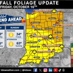
More fall color is showing up across Indiana, with portions of the state now reaching Moderate color! 🍁
If you're looking to get outside and enjoy some fall activities this weekend, the weather will certainly bring the fall feels!
Chilly & crisp mornings will bring widespread frost potential, with a few areas even facing a freeze threat.
By the afternoon, temperatures will warm nicely, with mostly sunny skies creating pleasant conditions for hiking, leaf-peeping, festivals, and other outdoor activities.
With more color developing across the state and a beautiful fall weekend ahead, this could be a great time to get outside and enjoy fall in Indiana! 🍂
#INwx #Indiana #FallInIndiana #IndianaFall #FallFoliage

🌬️ A WINDY DAY AHEAD
A strong area of low pressure will continue to move northeast of the region today, bringing strong winds across the area.
Many locations will see wind gusts of 20–30 mph today into tonight, with some areas potentially experiencing gusts up to 40 mph!
Be sure to secure loose outdoor items and bring in those Halloween and fall decorations before the winds pick up! 🍂🎃
#INwx #ILwx #OHwx #KYwx

CHILLY WEEKEND BRINGS FROST & FREEZE RISKS
Chilly air will move into the region over the next 24–26 hours, bringing our coldest air of the fall season so far. Widespread frost and freeze risks will develop Saturday and Sunday mornings.
Saturday morning is expected to bring the coldest conditions, with the greatest frost and freeze potential focused across the northern portions of the region.
By Sunday morning, much of the Ohio Valley could see temperatures drop into the 30s, with widespread frost possible across the region!
A significant change from the warmth we've experienced this week! 🍂🥶 #INwx #ILwx #OHwx #MIwx #WIwx #frost #freeze

⛈ SLIGHT RISK OF SEVERE WEATHER
The Storm Prediction Center has outlined portions of southeastern Illinois and central and southern Indiana in a Slight Risk (Level 2 of 5) for severe weather this afternoon and evening.
Primary Threats Include:
- Locally strong to damaging wind gusts
- A couple of tornadoes
Timing:
Southeastern IL: 2-6 PM CDT
Indiana: 6-11 PM EDT
Stay weather-aware and have a way to receive warnings if thunderstorms develop in your area.
#ILwx #INwx


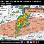
INCREASING STRONG TO SEVERE THUNDERSTORM THREAT?
We have been monitoring the potential for strong to severe thunderstorms today since early this week. Morning data has shown an uptick in the severe weather threat across portions of eastern Missouri, southern Illinois, central and southern Indiana, and southwestern Ohio for late this afternoon into the evening.
While there are still some questions regarding how the atmosphere will evolve throughout the day, the latest data suggests the potential for locally strong to damaging wind gusts and a couple of tornadoes. The greatest risk currently appears to be within the highlighted area.
We’ll continue to closely monitor the forecast throughout the day and keep you updated as conditions evolve!
#INwx #ILwx #MOwx #OHwx
INDIANA WEATHER WHIPLASH! 🌡️ 🌡️
We’re going from record heat on Tuesday, to the threat of strong to severe thunderstorms Thursday, followed by a major cooldown for the weekend. By Saturday and Sunday morning, temperatures could drop into the 30s with the possibility of frost!
You really don’t have to wait long for the weather to change in Indiana! 😅
#INwx #IndianaWeather #WeatherWhiplash
🤖 Made with AI

🌧️ ROUNDS OF RAIN THIS WEEK!
Rounds of rain and thunderstorms will move across the region today through Friday, bringing an active weather pattern before calmer conditions settle in for the weekend.
Rainfall totals of 1.00–1.50" are forecast through Friday evening across portions of southern and south-central Indiana, southern Illinois, and Missouri.
The repeated rounds of rain will also bring the potential for flash flooding, especially across the Ohio River area from today through tonight, where locally heavier rainfall could lead to rapid rises on area streams and low-lying areas.
#INwx #ILwx #MOwx #KYwx


STRONG TO SEVERE WIND GUSTS POSSIBLE TODAY
A Marginal Risk (Level 1 of 5) for severe weather has been outlined across portions of southern Illinois, southern Indiana, Kentucky, and Ohio today.
The main threat with thunderstorms will be locally strong to damaging wind gusts, with the greatest potential for strong to severe storms occurring from the mid-afternoon into the evening hours.
Stay weather-aware if you’ll be outdoors or traveling across the region today!
#INwx #ILwx #OHwx #KYwx

🥶 A CHILLING CHANGE IS COMING!
Highs across central Indiana will climb to near 90° this afternoon, but enjoy the summer-like warmth while it lasts! Much colder air is on the way, with a dramatic cooldown expected by the weekend.
By Saturday morning, temperatures are forecast to drop into the mid to upper 30s, bringing the potential for frost across portions of Indiana! 🍂
From summer-like heat to frosty mornings in just a few days! 🌡️ #INwx #weather #Summer #Fall

STRONG THUNDERSTORM THREAT THURSDAY ⚡
The Storm Prediction Center has issued a Marginal Risk (Level 1 of 5) for severe weather across portions of eastern Missouri, central and southern Illinois and Indiana, and Ohio on Thursday.
The main concern will be locally strong to damaging wind gusts, although the overall threat will depend on how conditions evolve throughout the day.
Stay weather-aware if you have outdoor plans on Thursday, and be sure to check back for updates as the forecast evolves!
#INwx #ILwx #OHwx #MOwx

ANOTHER HOT FALL DAY AHEAD! ☀️
The unseasonable heat continues across the Midwest today, with temperatures running 15–25° above normal! Many locations across the Ohio Valley could see daily high-temperature records fall once again today!
St. Louis is even in the running to challenge its all-time October high temperature of 94°, set in 2019!
The heat will ease over the next few days before a significant cooldown arrives late this week and continues into the weekend. Enjoy the summer-like warmth while it lasts, because a much more fall-like feel is on the way! 🍂 #INwx #ILwx #OHwx #MIwx #WIwx #heat

While we’ll start the week off dry, several rounds of rain are expected to move across the region from midweek through Friday.
Rainfall totals of 0.50–1.50" appear most likely across portions of Illinois, Indiana, and western Ohio through Friday evening. Stay tuned as timing and rainfall amounts continue to be refined! #INwx #ILwx #OHwx
