
Dmann101 retweeted
Wow.
Issued by the FAA just moments ago, ALL US airports are currently ground stopped. This means NO flights may depart for US airports. Flights already in the air will be allowed to land. This is related to an FAA equipment outage.

ALT DUE TO EXTRAORDINARY CIRCUMSTANCES AND FOR REASONS OF SAFETY. ATTENTION ALL AIRCRAFT OPERATORS, BY ORDER OF THE FEDERAL AVIATION COMMAND CENTER ALL AIRPORTS ARE GROUND STOPPED. ALL DEPARTING TRAFFIC SHOULD REMAIN GROUND STOPPED UNTIL FURTHER NOTICE. INBOUND INTERNATIONAL FLIGHTS WILL BE MANAGED ON A CASE BY CASE BASIS.
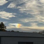
Stunning piece of a rainbow captured moments ago here in Etown, KY🌈
@NWSLouisville @Kentucky_WX @I65WxSils @0meterChasers @Kentuckyweather @Main_Event_Wx @ChrisAllenSkywx @wxornotBG @2kHoukWx
Dmann101 retweeted
Graupel showers will taper off this evening, then return tomorrow afternoon. There is a low chance that a couple snow flakes mix in with the heaviest showers tomorrow afternoon and evening. Then conditions turn dry over the weekend, but remain cool into early next work week.
Dmann101 retweeted
Hey @NWSLouisville , this was sent into us few minutes ago off our Facebook Page from Darren Johnson out in Plum Springs (Warren Co) looking North as that cell was passing through Eastern Edmonson Co near KY-101 as you come down the hill into Warren Co. There was some brief rotation for a few minutes on velocity.
Thanks
-@I65WxSils
Dmann101 retweeted
Southill hail @NWSLouisville
Pic from Taylor Deweese
Dmann101 retweeted
Just south of Terre Haute, Indiana
Full RAW video will be on my YouTube ASAP!
@ryanhallyall @WxWiseApp @NWSIndianapolis
Dmann101 retweeted
Along a strong cold front, showers and isolated thunderstorms will move through the region late Wednesday. Rainfall totals are expected to be fairly light, and there is a low-end chance for gusty winds and small hail with the strongest storms.
Dmann101 retweeted
The broken line of showers and storms will quickly move through the region from west to east late Wednesday. The map on the right side of the image shows our updated most likely time for strong storms.
Dmann101 retweeted
A cold front will move through the area tonight, bringing a chance for showers and thunderstorms. A few strong storms can't be ruled out early this evening. For the rest of the week, cooler and showery weather is expected. Dry and chilly weather is expected this weekend.
Dmann101 retweeted
Remember….
You don’t need a whole lot of CAPE (Storm Juice) this time of year for Storms to connect. The amount that’s showing can get the job done.
💨 ✅
⚡️ ✅
🌪️… 🤔… very low but the Dynamics can’t rule out for a small spinup or two.
Dmann101 retweeted
Since we are sort of limited now without good Mesoscale Data, it’s good to look at HRRR and the REFS. 12/18z is a little skewed, from comparing but as a “whole” the image on Left is cross section at 500mb. In Yellow is left exit region where better Storm chances are poss on Weds.
Dmann101 retweeted
Showers and storms should move quickly from west to east during the late afternoon and evening hours on Wednesday. The map on the right side of the image shows the most likely time for strong storms Wednesday evening.
Dmann101 retweeted
A strong cold front descending through the region Wednesday evening should bring a broken line of showers and storms. A few strong storms are possible, with gusty winds being the main severe weather hazard. Much cooler air and breezy conditions will move in for Thursday.

ALT This is the latest weather briefing slide for the chance of strong showers and thunderstorms across central Kentucky and southern Indiana on Wednesday. The key messages for the storm potential and the main forecast hazards and confidence are shown on the left side of the graphic. The Day 2 Storm Prediction Center severe weather outlook is shown on the right side.
Dmann101 retweeted
Showers and isolated storms will develop ahead of a strong cold front pushing through the region. While the main concern with the strongest storms is gusty to damaging winds, the threat for severe weather with this event is very low.
Dmann101 retweeted
Frosty conditions tonight will be followed by a freeze tomorrow night into Sunday morning. If you still have plants outside, take steps now to protect them from the elements.
Dmann101 retweeted
Patchy fog early this morning will give way to mostly sunny skies later on, with afternoon high temperatures in the mid 60s. A cool front will break widespread clouds and patchy drizzle tomorrow, with cool crisp mornings in its wake this weekend.


