



As today(10/16) #Hurricane #Isaias dropped 24 tornadoes across our region..
7 EF0 (Fl-1) (GA-2)(NC-4)
12 EF1 (GA-2)(SC-4)( NC-6)
5 EF2 (SC-2)(NC-3)
Check out our Tornado Survey Dashboard to learn more.
public.tableau.com/app/profi…
SERCC retweeted

A late-season #heatwave toppled additional records in the southern United States today. #Charlotte saw its latest 90F (32.2C) temperature. #Jonesboro saw its latest 95F (35.0C) temperature.

SERCC retweeted

Nine total tornadoes were confirmed from Sunday, October 11, 2026 including two EF-2 and five EF-1 tornadoes. This ties for the most tornadoes to occur on a single day in the NWS Raleigh, NC forecast area (2011 & 1992).

ALT Info graphic showing a map of the tornado touchdowns along with the intensity.
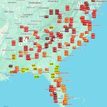
Wow.. We are convinced October decided to dress up as summer for Halloween.. Look at these Max. Temps. and daily records yesterday..
sercc.oasis.unc.edu/Map.php?…
@NWSEastern @NWSSouthern @NOAANCEI


SERCC retweeted

Looks like we will set the record for latest 90 degree day at KRDU on record. Previous latest date was October 10th with 90 on 10/10/2017 and 91 10/10/1939

SERCC retweeted

Now that the tropics have turned quiet again, let’s look ahead to this winter.
A super El Niño means big boom/bust potential for the Carolinas.
There have only been 3 super El Niños on record since 1950. Here’s what happened in each of those winters.

SERCC retweeted

The remnants of Hurricane Isaias affected North Carolina last weekend, bringing heavy rain and high winds in the west and severe weather farther east. #ncwx
Our latest blog post has more on this storm and its wide-reaching impacts across the state.
📰: climate.ncsu.edu/blog/2026/1…

ALT A map of total precipitation, maximum wind gusts, and confirmed tornadoes in North Carolina from the remnants of Hurricane Isaias
SERCC retweeted

The great pumpkin escape! 🎃💨 A giant inflatable pumpkin made a run for it in Cary, North Carolina, just outside Raleigh, as strong winds from Isaias sent it rolling away. And yes, the pumpkin made it back home!
SERCC retweeted

Below are some of the preliminary observed rainfall reports associated with Isaias over the last two days.


SERCC retweeted

JUST IN: Saildrone Explorer SD-1045 passed through the eye of Category 3 Hurricane Isaias, recording wind gusts over 90 knots (103 mph).
This is the same USV that filmed inside Hurricane Sam in 2021, setting a Guinness World Record.
Watch ↓ @NOAA_AOML @noaapmel
Oh my if accurate now.
Thoughts @NWSMobile


4.51 in an hour at Elgin AFB in #Florida from #Isaias
mesonet.agron.iastate.edu/ra…
@NWSTallahassee @NWSMobile @FLClimateCenter

4.51 in an hour at Elgin AFB in #Florida from #Isaias
mesonet.agron.iastate.edu/ra…
@NWSTallahassee @NWSMobile @FLClimateCenter
SERCC retweeted

It’s hard to believe that it’s already been two years…
45 known tornadoes (3 EF3’s, 6 EF2’s, 25 EF1’s, 7 EF0’s, & 4 EFU’s) occurred prior to Hurricane Milton’s landfall, the most tornadoes associated with any tropical cyclone in Florida history.
Loop: NWS Melbourne/IEMCOW

October 8-9, 2024:
One of Florida's largest tornado outbreaks on record was spawned by Hurricane Milton. 45 tornadoes impacted the Sunshine State, nine of which were significant (EF2+). Six people were killed by an EF3 at the Spanish Lakes community near Fort Pierce.
#wxhistory


The #DailyDeluge yesterday in #FL was near near @CityofJax .
14th Wettest day on Record & 4th Wettest October day.
sercc.oasis.unc.edu/Map.php?…
@NWSJacksonville @FLClimateCenter @NWSSouthern @DRmetwatch @NOAADrought


SERCC retweeted

If #Isaias sounds familiar, it should.
Hurricane Isaias hit North Carolina in 2020. It brought bad storm surge to Oak Island, high winds to the coast, and lots of tornadoes to NC.

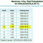
Impressive daily rain for @ApalachicolaFL yesterday(7.49 in.). T-1 wettest October day and T-6 wettest day on record. POR only 1975-curr.
sercc.oasis.unc.edu/Map.php?…
@NWSTallahassee @NWSSouthern @FLClimateCenter @NOAADrought #flwx

SERCC retweeted
October 1st starts a new "water year".
This 12 month period is a clean reset for seasonal rainfall, and captures all of the winter rather than splitting it in two.
October 2025 - September 2026 was our *driest* water year on record dating back to 1903 for Greensboro.

SERCC retweeted

The 2026 Atlantic #hurricane season continues to be remarkably quiet, producing the least Accumulated Cyclone Energy (ACE) to date since 1950. ACE is an integrated metric accounting for storm intensity and duration.

Here is the chart from #IEM.


