

🌦️ Boston Meteorologist @wcvb5 🎓 Rutgers Alumnus ⛳ Golf • 🎿 Ski • 🏐 Volleyball
BOSTON
Joined September 2015
- Tweets4.4K
- Following324
- Followers1.1K
- Likes539






Sean Kelly retweeted

As the storm evolves and colder air starts to drain in from the north, snow could mix-in and stick in our higher elevations.
East slopes of the Berkshires could see a light accumulation of snow, with a coating of snow possible in the northern Worcester Hills. #wcvb

Sean Kelly retweeted
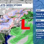
Late-week storm update:
> Chilly rain showers arrive Thursday
> A changeover to snow will start in the mountains of Northern New England Friday, steady rain south
> A brief mix to wet snow possible late Friday in the higher elevations of S. New England. #wcvb


Sean Kelly retweeted
A few showers creep in Thursday afternoon, but the greatest impact from our next storm will be felt Friday - early Saturday. #wcvb

Sean Kelly retweeted
The peak of our warm stretch arrives today. Approaching record territory-can't rule out a few spots hitting 80 degrees! #wcvb

Sean Kelly retweeted
BIG changes! An area of low pressure set to bring rain Friday will also usher in the COLDEST air of the season this weekend. It will be cold enough to see the first sign of snow in the mountains and the first freeze for many southern New England suburbs. #wcvb


Sean Kelly retweeted
4PM SATURDAY
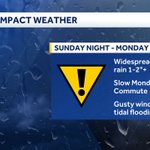
You can clearly see our nor'easter spinning to the south- more than 200 miles south of Boston. Periods of rain with gusty NE winds will continue into Sunday AM as the storm ticks north and west. Sunday afternoon the winds die down but rain continues thru Monday #WCVB
Sean Kelly retweeted
Block Island observed a wind gust of 71 mph around 4am! Wellfleet observed a gust of 68 mph late last night.
Right now, there is a tight wind gradient. Gusts are near 50 mph on the Cape & islands, but only near 30mph around Boston. This will expand north by this evening. #wcvb


Sean Kelly retweeted
NOR'EASTER looking impressive on satellite as it spins in the ocean more 300miles to our south. Winds picking up now and peak Saturday-Sunday AM gusts 50mph+ near coast. Squally bands of rain are heaviest Saturday afternoon-Sunday. Rain lingers Monday but winds come down #WCVB
Sean Kelly retweeted
Happy First Day of School to kids in Boston and many surrounding towns in MA! #wcvb


Sean Kelly retweeted

Salt Lake fire is dumping a lot of water on this fire, but it is burning hot and putting up a plume of toxic smoke.
Fire is reportedly affecting traffics southbound Redwood Rd at MP 59 Salt Lake Co.
369 South Orange Street, Salt lake City
Metech Recycling
Video: David Ochoa
Sean Kelly retweeted

Fire danger will increase across Utah on Wednesday — especially in southern and western parts of the state — as gusty winds, hot temperatures, and dry thunderstorms develop. #utwx
