

🌦️ Boston Meteorologist @wcvb5 🎓 Rutgers Alumnus ⛳ Golf • 🎿 Ski • 🏐 Volleyball
BOSTON
Joined September 2015
- Tweets4.4K
- Following324
- Followers1.1K
- Likes539






Happy Sunday morning everyone! A quick-hitting storm will bring heavy rain to eastern Mass late this evening through 3 AM or so. Lingering showers will be possible through 7am. Still expecting about 1 to 2" with highest totals east.

21


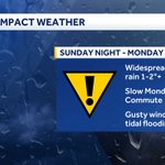
Storm 1 of 3 moves in tomorrow evening bringing us widespread heavy rain through early Monday morning. Gusty winds are expected with upwards of 1 to 3 inches. Another more impactful storm likely moves in on Thanksgiving day which could potentially bring travel delays.

All eyes on a potential coastal storm arriving Sunday night into Monday. Right now it looks like a good widespread soaking rain with the potential of some tidal flooding as we near our next full moon. Stay with us for updates.

47
Good Wednesday evening everyone! We have some gorgeous weather that will continue through the rest of the week and into the start of the weekend. Enjoy the warmth while it lasts, a big cooldown is expected for Thanksgiving week.

26
Happy Saturday morning everyone! Mostly cloudy skies today with highs in the middle 40s. A few lingering rain/snow showers across the Berkshires and mountains of northern NE. Otherwise, drying out with temps closer to 50 degrees Sunday. A big warm up returns for the work week!

27


Chilly rain is expected to move in tomorrow evening through Friday. As colder air moves in, rain could mix with or change to wet snow across the higher elevations, especially the Berkshires and Worcester Hills. A brief coating on grassy surfaces is possible in spots.


1
3
81
Sean Kelly retweeted

As the storm evolves and colder air starts to drain in from the north, snow could mix-in and stick in our higher elevations.
East slopes of the Berkshires could see a light accumulation of snow, with a coating of snow possible in the northern Worcester Hills. #wcvb

Sean Kelly retweeted
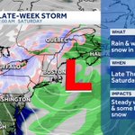
Late-week storm update:
> Chilly rain showers arrive Thursday
> A changeover to snow will start in the mountains of Northern New England Friday, steady rain south
> A brief mix to wet snow possible late Friday in the higher elevations of S. New England. #wcvb


There is still lots of uncertainty with our end-of-the-week storm. Timing likely will be Thursday night through Saturday morning with the heaviest rain on Friday. Snow will fall across our northern mountains with maybe even some wet snowflakes for higher elevations in MA.

50
Happy Sunday morning everyone! Our storm is finally out of here as some sunshine returns today. Highs will climb into the mid-50s with gusty winds.

30
Good Saturday morning everyone! It is a rainy start to the weekend with many areas picking up 3 to 6 inches of rain over the past 48 hrs. Rain will continue to wind down as we head into the afternoon with sunshine returning by Sunday afternoon.

54
What month are we in?! It has been gorgeous all across the area today as temperatures climbed to more than 20 degrees above normal. We will likely remain in the 70s through Friday.

34
Sean Kelly retweeted
A few showers creep in Thursday afternoon, but the greatest impact from our next storm will be felt Friday - early Saturday. #wcvb

Sean Kelly retweeted
The peak of our warm stretch arrives today. Approaching record territory-can't rule out a few spots hitting 80 degrees! #wcvb

With a sunset at 4:36 pm we are now down to only 10 hrs and 17 min of daylight! The days are falling shorter and shorter by 2 and a half minutes. Sun angle is now less than 33 degrees.

40
How about this for the start of November: We could likely hit the 70s everyday this week! Are you enjoying this warm up?

2
147
Happy Halloween everyone! I hope everyone is enjoying the peak foliage out there. Chilly weather returns tonight with lows falling below freezing in many location. Don't forget we fall back tonight and gain that extra hour of sleep!

41
