

Giving updates on the weather in Ireland each day. I will try to give warnings and safety information too as they occur.
Ireland
Joined February 2019
- Tweets3.2K
- Following69
- Followers9.4K
- Likes345








⚠️ Status Yellow - Fog warning
Issued for Leinster, Munster, Galway
Met Éireann Weather Warning
Be Aware, Fog developing, dense in places.
Poor visibility.
Hazardous travelling conditions.
Valid: 22:00 Friday 06/11/2026 to 10:00 Saturday 07/11/2026

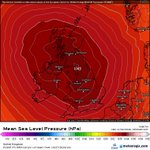
😍🔴 Record breaking high pressure? 🔴😍
After a few stormy days high pressure is forecast to build over the weekend and it will bring much needed settled and calmer weather to Ireland.
The record in October in Ireland for high pressure is 1043.8hPa set back in 2018 at Sherkin Island. This high pressure is forecast to get up to 1043 and depending on positioning it could be close to getting a new record!
Just to note high pressure does not mean warm and sunny. Depending in where it is located it can bring cloud and cold air too but it will be drier than what we have experienced over the past week.
Watch this space!

Like our weather forecasts and want more?
Join my patreon and support Weather Alerts Ireland where regular updates are made especially when the weather becomes stormy.
Storm Tracker members gets full detailed information and analysis on storms when they are forecast.
patreon.com/cw/weatheralerts…
Thanks,
Nick
Weather Alerts Ireland

⚠️ Storm with no name
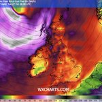
Another wild day ahead today on Bank Holiday Monday.
The system will push past the north west towards Scotland. For Ireland it will be a wet and very windy day!
Over 30mm is expected to fall in the next 24 hours with a chance of an isolated thunderstorm this evening.
In the west gusts possibly exceeding 100km/h today with inland seeing gusts exceeding 80km/h.
Watching the models closely as a band of heavy rain will cross the country this evening and could bring some very gusty conditions and some thunderstorms.


Hey All,
I hope you found my forecasts helpful over the past few days with #StormAusten and #StormBoelo . We went from the rain and flooding of Storm Austen to the high winds and rain from Storm Boelo. And another windy and wet night ahead!
To all the new followers thank you for following my page and welcome :) I am Nick Critch and I run this weather page in my own time! Hopefully you will find my forecasts helpful over the winter and beyond!
If anyone wants to support my page or buy me coffee then here is the link 😮💨 buymeacoffee.com/weatheraler…
Thanks,
Nick Critch
Weather Alerts Ireland

We have one more system/storm to go before a little calmer period!
So this system will have a similiar path to #StormBoelo but does not look to have the same intensity.
Rain will push in overnight and will push across the country, followed by another band tomorrow afternoon. Over 50mm is possible in 24 hours on higher ground in the west. Lower ground seeing 15-20mm.
Strong winds will build in the morning also and will bring gusts exceeding 100 or even 110km/h to the north west of the country.

One more stormy spell ahead from midnight!
Full details here!
patreon.com/weatheralertsire…

🚨 MALIN HEAD HAS SUSTAINED WINDS OF 100KM/H at 10pm.
Also a gust of 133km/h which has red warning criteria met.
Finner and Mace Head have also got red warning criteria for mean wind speeds at 10pm.
#StormBoelo

⚠️⚡️ Lots of power outages around the country this evening and more to come overnight I would think!
Pics by esb powercheck and nienetworks
#StormBoelo


🚨 4pm Update on Storm Boelo!
Mace Head in Red Warning Criteria for mean wind speeds of 89km/h!
Also recorded a gust of 122km/h
#StormBoelo


A very wet morning out there as the rain band from #StormBoelo pushes across the country.
Over 37mm has fallen in Galway and over 40mm has fallen down by Glengarriff since midnight!
Road conditions will be poor in many areas so please take care!
Winds will increase throughout the day especially in the north west! Will do another post on winds soon!

📳⚠️ Storm Boelo to impact Ireland overnight and over the weekend.
The outer rain bands of this storm will push in from the west overnight and will bring heavy rain across the country overnight and tomorrow.
Over 60mm is expected to fall on higher ground in 24 hours in Kerry and this adding to the heavy rain from last night it will only increase the risk of localised and river flooding.
This rain will slowly clear from the west throughout the late morning. Then heavy showers will follow.
The winds will also pick up in the morning and will slowly strengthen as the centre of the storm moves further east, the centre of the storm will move towards Scotland and this will bring strong winds to Ireland on the south side of the storm.
Gusts will really pick up in the west and north west in the late afternoon and gusts over 100km/h are likely in most western coastal areas. Gusts inland possibly exceeding 90km/h in parts of the midlands to north.
‼️ From 7pm in Donegal, Derry and Antrim coastal areas will see very strong and possibly damaging gusts moving in. Gusts exceeding 130km/h are possible in coastal northern areas and possibly exceeding 140km/h in exposed areas like Malin Head!
These winds will continue through the early hours of the morning and then slowly ease towards dawn. Calming from the South slowly Sunday morning but for northern areas it will take most of Sunday to calm down.
So overall a very wet night with a risk of flooding for the west and Kerry in particular, rain moving east throughout the night, and then winds picking up and becoming very strong in the late afternoon and evening.


⚠️ 3 Orange Warnings Issued for #StormBoelo! ⚠️
📳 Status Orange - Rain warning
Issued for Kerry
Storm Boelo will bring spells of very heavy and intense rain.
Prepare for impacts:
* Damage to homes and businesses expected
* Disruption and delays to public transport (rail, bus)
* Flooding expected
* Outdoor events severely disrupted
* Very difficult travelling conditions
Valid: 07:00 Saturday 24/10/2026 to 14:00 Saturday 24/10/2026
📳 Status Orange - Wind warning
Issued for Donegal, Galway, Leitrim, Mayo, Sligo
Storm Boelo: Gale force westerly winds with severe and damaging gusts.
Prepare for impacts:
* Damage to already weakened structures
* Damage to power lines, power outages
* Disruption and delays to public transport likely (air, rail, bus, ferry)
* Fallen trees
* Large coastal waves
* Loose objects displaced
* Coastal flooding where winds onshore
* Very difficult travelling conditions, dangerous conditions at sea
Valid: 14:00 Saturday 24/10/2026 to 09:00 Sunday 25/10/2026
📳 Status Amber - Wind warning
Issued for Derry and Antrim
The strongest winds from Storm Boelo are expected from Saturday evening and extend eastwards through Sunday.
Valid: 21:00 Saturday 24/10/2026 to 21:00 Sunday 25/10/2026
All warnings at met eireann and met office websites

😮😳 New Detailed post about Storm Aeden, Storm Boelo and possibly Storm Chloe!
Check this out as it is going to be a rough weekend with heavy rain, flooding and strong winds and this could well continue into next week!
patreon.com/weatheralertsire…

I managed to capture a double moonbow last night in Kerry, Ireland! 🌈
Never seen a moonbow in my life and there was a double!
Photo was taken at around 11pm.
@metoffice @Petagna is it rare to see a double?

⚠️ Storm Austen Today
We have and will see worse storms in Ireland as the worst of the winds to remain well offshore but still some gusty conditions in the southern coastal counties. Possibly exceeding 100km/h overnight here. Over the weekend we will likely see higher wind gusts than what we will see with #StormAusten.
The main issue will be the rain and my rain gauge has recorded a further 20mm over the last couple of days so ground is saturated in Kerry.
Higher ground in the south could well see in excess of 70mm in 24 hours with many lower ground areas in the south seeing over 30mm in 24 hours.
Risk of flooding!

