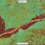
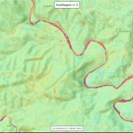
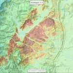
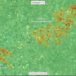
October flood woes along the #Niger and #Benue Rivers is clearly visible using #Sentinel2 imagery and the @HazMapper #rdNDVI algorithm. Contiguous red areas = loss of vegetation during #NigeriaFloods inundation. Explore yourself with the direct URL at cmscheip.users.earthengine.a…;
For those following the Oct 8-9 Las Tejerías landslide disaster in Venezuela, the @HazMapper +rdNDVI output clearly shows the shallow landslides and debris flows. Explore in HazMapper at cmscheip.users.earthengine.a…; and see @davepetley blog post-blogs.agu.org/landslideblog/…
A quick comparison of mapping landslides (August 2021 Nippes EQ in #Haiti) in the original HazMapper compared to the beta v1.1 which includes moving from TOA to SR Sentinel data and some additional cloud filtering techniques.
#googleearthengine #gee #bigdata #naturalhazards
The rdNDVI metric is also useful for identifying vegetative stress from #flooding. Very cool to see researchers implement HazMapper for a flooding study in Afghanistan! Recent article from Atefi and Miura. Good stuff!!
researchgate.net/publication…
Our new research article was published in a peer-reviewed #remotesensing journal.
The paper proposed a method for #detection, #monitoring, and #prediction of Flood Prone areas. The method is applied in #a_flash_Flood of #charikar, #Afghanistan #Floods, 2020.
Lots of #debrisflows initiating on the high topography around Emamzadeh Davod last week.
A cloud is right over town in the latest #Sentinal2 image but still can see the track via link below. You'll see many more panning to the NW
cmscheip.users.earthengine.a…;
The 27 July 2022 Imamzadeh Dawood mudflow disaster in the mountains near Tehran is one of a number of recent landslides in Iran over the last week or so. At least 100 people have been killed or are missing:- blogs.agu.org/landslideblog/…
HazMapper retweeted
When you’re trying to find the location of a vaguely described landslide and @HazMapper comes to the rescue to find it. Recent landslide in Quebec.
HazMapper Weekly Update #22 - April 2022 flooding and minor landsliding along the Mlazi (uMalzi) River, on the suburban fringe of Durban, South Africa.
Check out the @HazMapper pre-post GIF of the August 7, 2021, rainfall-induced landslide on Mt. Silabaku, Taiwan, and the resulting debris flow along the Yusui Stream. Inspiration from the new paper in the journal #Landslides by Che-Ming Yang and coauthors doi.org/10.1007/s10346-022-0…
Another large fire in New Mexico, this time the 100,000+ acre combined #CalfCanyonFire and #HermitsPeakFire, seen here as of April 28th #rdNDVI vegetation change map (reds = veg loss due to fire). Explore in @HazMapper at direct URL: cmscheip.users.earthengine.a…; @inciweb @SantafeNF
@HazMapper fire intensity proxy (#ndvi) map for the #McBrideFire near #Ruidoso, #NewMexico as of April 12, 2022, using #Sentinel2 imagery and #EarthEngine. The fire has caused several fatalities and destroyed more than 200 homes. Direct Hazmapper URL:cmscheip.users.earthengine.a…;
@HazMapper #NDVI change-detection result for the ongoing March #wildfires in central #Texas that are part of the #EastlandComplex. Fires are located between the cities of Cross Plains and Gorman. Warm colors = vegetation loss due to fire activity. @inciweb @TDEM

ALT Central Texas Wildfires, as of March 20, 2022. HazMapper Net Difference Vegetation Index (NDVI) result comparing Sentinel-2 imagery data for the two weeks before and 1 day after March 20, 2022. Warm colors represent vegetation loss due to fires. Ironically, fires have burned around the town of Carbon, Texas.
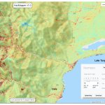
April 2020, heavy rains triggered hundreds of landslides along the rift-flank mountains west of Lake Tanganyika. Resulting debris flows and floods caused substantial damage in #Uvia #DRC. @HazMapper #rdNDVI image is a nice example of #SourceToSink sediment transport.
One year on from significant #landslide and debris flow events in Quang Tri Province, #Vietnam caused by the consecutive passage of multiple tropical cyclones.
Explore with @HazMapper URL: cmscheip.users.earthengine.a…;
@HazMapper direct URL for event: cmscheip.users.earthengine.a…;
June 2021 #DebrisFlow and flooding near Santa Rosa de Osos, Antioquia, #Columbia. Red colors show vegetation loss due to transport and deposition of material on debris fan where the village is situated. #NaturalHazards #GEE #sentinel2
@HazMapper #rdNDVI result for May 2021 Mt. Nyiragongo lava flows, #DRCongo. Unfortunately, these resulted in the loss of life and destruction of > 1000 homes north of #Goma.
Explore with the direct URL: cmscheip.users.earthengine.a…;
In June 2021, a ~500 m wide landslide temporarily blocked the Melamchi River of Nepal. The #Outburst flood caused significant damage and loss of life ~25 km downstream in the town of #Melamchi; @nepalflyinglabs.
Explore the event via @HazMapper direct URL cmscheip.users.earthengine.a…
Here is the direct URL for the @HazMapper #rdNDVI change result for the June 2020 river-blocking landslide near Melamchigaon village, #Nepal.
cmscheip.users.earthengine.a…
And here is the direct URL for the @HazMapper #rdNDVI change result for the June 2020 outburst flood in the vicinity of #Melamchi #Nepal.
cmscheip.users.earthengine.a…;