

Official page for the Santa Fe National Forest
Santa Fe, NM
Joined May 2009
- Tweets6.5K
- Following232
- Followers9.3K
- Likes274

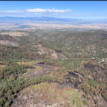


🔥 The Santa Fe National Forest plans to begin the 412-acre Paliza Prescribed Fire as early as Oct. 20 near Ponderosa, NM. This treatment will reduce hazardous fuels, improve forest health, and help lower wildfire risk in the Jemez Mountains.
💨 Smoke may be visible in nearby communities.
For full news release visit: fs.usda.gov/r03/santafe/news…
More info: fs.usda.gov/r03/santafe/fire…
Forest Road 263 in Gallinas Canyon remains closed for administrative use and private inholdings after heavy rainfall caused significant washouts and structural damage, making the route impassable. The road is closed to the public. Road closures will be posted on the SFNF website under alerts and can be found here. fs.usda.gov/r03/santafe/aler…...

Upcoming Prescribed Fires on the Santa Fe National Forest
The Santa Fe National Forest is planning prescribed fires this fall anticipating work will begin as early as October as conditions allow.
We recognize that this fire season has been challenging for many communities. Your experiences matter, and we are committed to approaching prescribed fire with close coordination with state and local partners. We plan every prescribed fire under the right conditions, using the best available science and extensive safeguards and acknowledge that conditions may limit, or even pause, the work this fall and winter. Prescribed fire remains one of the most effective tools we have to reduce wildfire risk, protect communities, and improve forest health
To learn more about upcoming projects see the full news release here: fs.usda.gov/r03/santafe/news…
For ongoing prescribed fire information visit our Prescribed Fire web page: fs.usda.gov/r03/santafe/fire…

The Frijoles Fire is 90% contained. Remaining work needs rock delivery and engineering assistance and will be completed by the district. This is the last regular update about the Frijoles Fire.
For more information, visit InciWeb: inciweb.wildfire.gov/inciden…
En español: inciweb.wildfire.gov/inciden…


The Frijoles Fire is 78% contained, 15,956 acres, and 47 personnel are assigned. Crews continue to make progress on repair work between storms.
For more information, visit InciWeb: inciweb.wildfire.gov/inciden…
En español: inciweb.wildfire.gov/inciden…

Ya está disponible el Informe Resumido sobre el Área Quemada del incendio Frijoles.
Para más información: inciweb.wildfire.gov/inciden…
El incendio Frijoles tiene 15,956 acres y está contenido en un 74% | La lluvia reduce la actividad del incendio y genera peligros asociados a las condiciones húmedas en el incendio Frijoles.
Para más información: inciweb.wildfire.gov/inciden…

The Frijoles Fire is 15,956 Acres and 74% contained. Rain reduces fire activity and creates wet-weather hazards on the Frijoles Fire.
For more information: inciweb.wildfire.gov/inciden…
A Burned Area Emergency Response (BAER) team has completed their assessment of the Frijoles Fire to identify and manage potential risks to resources on National Forest System lands. The goal of the BAER program is to reduce threats through appropriate emergency measures to protect human life and safety, property, and critical natural or cultural resources. In addition to the BAER effort, a preliminary vegetation mortality assessment has been completed. These assessments focused on 15,483 acres within the fire perimeter. Currently the fire is 15,956 acres with 79% containment. Once full containment is reached the Forest Service will consider additional BAER assessments if warranted on the more recently burned areas.
Most of the burned area experienced unburned/very low (10%) or low (70%) soil burn severity located primarily in fire-adapted ponderosa pine and dry mixed conifer forests. There are some areas, in dry mixed conifer forests, that burned with greater intensity and experienced moderate (15%) or high (5%) soil burn severity. Soil burn severity is an important predictor of post-fire watershed impacts such as flooding and debris flows. These effects are expected to be realized primarily on National Forest land as there is an unburned buffer between the fire edge and Forest boundary. However, there is potential for ash, woody debris, and sediment to be carried beyond the Forest boundary under the right conditions. Expected vegetation mortality is relatively low and the fire tolerant forests are likely to recovery naturally.
The Frijoles Burned Area Summary Report is available as an incident publication and can be downloaded as a pdf file on the Santa Fe National Forest Website. Updated information about the Frijoles Fire operations, soil burn severity, maps, and BAER information are provided at the same site.

🔥 La lluvia y la nubosidad brindan alivio temporal a los bomberos en el incendio Frijoles.
Contacto:
(505) 407-5343
[email protected]
fs.usda.gov/r03/santafe
Santa Fe, N.M., 16 de septiembre de 2026 – La lluvia y la nubosidad brindan alivio temporal a los bomberos en el incendio Frijoles. Las temperaturas más frescas y la mayor humedad ayudarán a la recuperación de la humedad de los combustibles en el área del incendio. Es probable que continúen las condiciones húmedas durante los próximos días; se espera que la cantidad de lluvia hasta esta tarde sea de entre un cuarto y tres cuartos de pulgada. Se espera menos humo y el crecimiento del incendio está detenido temporalmente.
Operaciones en curso y planificadas: El incendio tiene actualmente 15,956 acres y está contenido en un 74 %, con 49 personas asignadas al incendio. La reparación por actividades de supresión continúa, y los bomberos siguen evaluando el acceso seguro y las tácticas para suprimir completamente el incendio dentro del terreno accidentado y peligroso del área silvestre Pecos Wilderness.
El Equipo de Respuesta de Emergencia para Áreas Quemadas (BAER) continúa realizando evaluaciones para determinar los impactos posteriores al incendio. Se publicó el mapa de Severidad de Quema del Suelo, el cual puede consultarse en InciWeb. La línea telefónica de información del incendio Frijoles, así como el correo electrónico del incidente Frijoles, estarán disponibles para información relacionada con la evaluación BAER.
Calidad del aire y humo: El humo también podría asentarse en la base de las montañas Sangre de Cristo. Las comunidades de Española, Santa Cruz, Chimayó, Cordova, Nambé, Pojoaque y Tesuque podrían experimentar acumulación de humo durante las tardes-noches y las primeras horas de la mañana. El humo será visible desde esas comunidades, así como desde Los Álamos y Santa Fe.
Seguridad: Evite viajar por arroyos o cauces si es probable que llueva o si ve que se forman nubes monzónicas. Si lo toma por sorpresa, muévase rápidamente a terreno más alto y espere a que el agua baje. No entre en aguas de inundación; pueden ser más fuertes de lo que piensa y el terreno debajo podría ser inestable. El cierre temporal del área forestal fue levantado el sábado, 12 de septiembre de 2026.
Aunque el área ya está abierta al público, instamos a los visitantes a estar atentos al tráfico relacionado con el incendio en la zona. La seguridad de los bomberos y del público es la prioridad número uno. Tenga precaución, ya que hay vehículos de bomberos y equipo pesado cerca del incendio y aún representan un peligro al conducir.
El uso no autorizado de drones puede impedir las operaciones de combate del incendio y representa un riesgo para la seguridad de los bomberos.
Para obtener más información, visite el sitio web del Bosque Nacional Santa Fe, sus redes sociales —Facebook y X—, InciWeb y NM Fire Information. La próxima actualización diaria del incendio Frijoles se proporcionará el viernes, 18 de septiembre de 2026.
Acerca del Servicio Forestal: Durante más de 100 años, el Servicio Forestal del USDA ha reunido a personas y comunidades para responder al llamado de la conservación. Basado en ciencia y tecnología de clase mundial, y arraigado en las comunidades, el Servicio Forestal conecta a las personas con la naturaleza y entre sí. El Servicio Forestal cuida los recursos naturales compartidos de maneras que promueven una vitalidad económica, ecológica y social duradera. La agencia administra 193 millones de acres de tierras públicas, brinda asistencia a propietarios de tierras estatales y privadas, y mantiene las organizaciones de investigación sobre incendios forestales y silvicultura más grandes del mundo. El Servicio Forestal también tiene un papel directo o indirecto en la administración de aproximadamente 900 millones de acres forestales dentro de Estados Unidos, de los cuales más de 130 millones de acres son bosques urbanos donde vive la mayoría de los estadounidenses.


🔥Rain and cloud cover provide temporary relief for firefighters on the Frijoles Fire
Contact:
(505) 407-5343
[email protected]
fs.usda.gov/r03/santafe
Santa Fe, N.M., September 16, 2026 – Rain and cloud cover provide temporary relief for firefighters on the Frijoles Fire. Cooler temperatures and higher humidity will help with fuel moisture recovery in the fire area. Wet conditions are likely the next couple of days, rainfall amount through this afternoon is expected to be between one quarter and three quarters of an inch. Less smoke is expected and fire growth is temporarily halted.
Ongoing & Planned Operations: The fire is currently 15,956 acres and 74% contained, with 49 personnel assigned to the fire. Suppression repair is ongoing and firefighters continue to assess safe access and tactics to fully suppress the fire within the rugged and hazardous terrain of the Pecos Wilderness.
The Burned Area Emergency Response (BAER) Team continue assessments to determine post fire impacts. The Soil Burn Severity map was released and can be viewed on Inciweb. The Frijoles Fire information phone line as well as the Frijoles Fire incident email will be available for information regarding the BAER assessment.
Air Quality & Smoke: Smoke may also settle at the base of the Sangre de Cristo mountains, the communities of Espanola, Santa Cruz, Chimayo, Cordova, Nambe, Pojoaque and Tesuque may experience smoke settling in the evenings and early mornings. Smoke will be visible from those communities as well as from Los Alamos and Santa Fe.
Safety: Avoid traveling in arroyos or stream beds if rain is likely or you see monsoon clouds building. If you get caught off guard, move quickly to higher ground and wait for the water to recede. Don’t enter floodwaters – they may be stronger than you think and the ground beneath could be unstable. The temporary forest area closure was terminated Saturday, September 12, 2026. While the area is now open to the public, we urge visitors to be aware of fire traffic in the area. Firefighter and public safety are the number one priority. Use caution as fire vehicles and heavy equipment are present near the fire and still pose a driving hazard.
Unauthorized drone use can impede firefighting operations and presents a risk to firefighter safety.
For more information, visit the Santa Fe National Forest website, social media (Facebook and X), InciWeb, and NM Fire Information. The next Frijoles Fire daily update will be provided Friday, September 18, 2026.


With cooler wetter area in our area this week, please be heads up if you are traveling or recreating in or near any recently burned areas!

The Frijoles fire had approximately 410 acres of growth over the past few days
Santa Fe, N.M., September 14, 2026 - The Frijoles fire had approximately 410 acres of growth over the past few days as fire made its way into drainages below Sierra Mosca. A large smoke column was visible on September 11, 2026, and was the result of fuel loading in these drainages catching fire. The fire is still burning in the wilderness and currently does not pose risk to property or people. Resources are assessing best tactics to fully suppress the fire. Full containment will be a slow process as the terrain in the Pecos Wilderness is rugged and hazardous. Firefighter and public safety are the number one priority. The ability for firefighters to safely fight this fire depends on availability of rescue resources and adequate medical evacuation sites in the event a firefighter gets hurt on the fire line.
Ongoing & Planned Operations: The fire is currently 15,956 acres and 79% contained, with 49 personnel assigned to the fire. Repair work from suppression damage continues as firefighters continue to assess safe access and tactics to fully suppress the fire within the rugged and hazardous terrain of the Pecos Wilderness.
The Burned Area Emergency Response (BAER) Team continue assessments to determine post fire impacts. The Soil Burn Severity map was released and can be viewed on Inciweb. The Frijoles Fire information phone line as well as the Frijoles Fire incident email will be available for information regarding the BAER assessment.
Air Quality & Smoke: Smoke may also settle at the base of the Sangre de Cristo mountains, the communities of Espanola, Santa Cruz, Chimayo, Cordova, Nambe, Pojoaque and Tesuque may experience smoke settling in the evenings and early mornings. Smoke will be visible from those communities as well as from Los Alamos and Santa Fe.
Safety: The temporary forest area closure was terminated Saturday, September 12, 2026. While the area is now open to the public, we urge visitors to be aware of fire traffic in the area. Firefighter and public safety are the number one priority. Use caution as fire vehicles and heavy equipment are present near the fire and still pose a driving hazard.
Unauthorized drone use can impede firefighting operations and presents a risk to firefighter safety.
For more information visit the Santa Fe National Forest website, social media (Facebook and X), Inciweb, and NM Fire Information. The next Frijoles Fire daily update will be provided Wednesday September 16, 2026.
About the Forest Service: The USDA Forest Service has for more than 100 years brought people and communities together to answer the call of conservation. Grounded in world-class science and technology– and rooted in communities–the Forest Service connects people to nature and to each other. The Forest Service cares for shared natural resources in ways that promote lasting economic, ecological, and social vitality. The agency manages 193 million acres of public land, provides assistance to state and private landowners, maintains the largest wildland fire and forestry research organizations in the world. The Forest Service also has either a direct or indirect role in stewardship of about 900 million forested acres within the U.S., of which over 130 million acres are urban forests where most Americans live.


El humo del Incendio Frijoles continuará siendo visible
Santa Fe, N.M., 11 de septiembre de 2026 - Las condiciones más cálidas y secas, junto con la disponibilidad de combustibles en el borde este del incendio, están contribuyendo al aumento de la actividad del fuego. El incendio está avanzando hacia áreas de pinos que aún no se han quemado dentro de varios drenajes en el borde al este. Estos combustibles disponibles y receptivos continuarán siendo consumidos por el fuego, lo que generará cantidades adicionales de humo. El incendio continúa avanzando dentro del Área Silvestre Pecos en dirección a Sierra Mosca. Actualmente, el incendio no representa ningún riesgo para las personas ni las propiedades en el borde al este. La próxima actualización se publicará el lunes 14 de septiembre de 2026.
Operaciones en curso y planificadas: Actualmente, el incendio abarca 15,546 acres y se encuentra contenido en un 79%, con 58 personas asignadas al incidente. Continúan las labores de rehabilitación de las áreas afectadas por las operaciones de supresión, mientras los bomberos siguen evaluando rutas de acceso seguras y tácticas para lograr la supresión total del incendio dentro del terreno escarpado y peligroso del Área Silvestre Pecos.
El Equipo de Respuesta de Emergencia para Áreas Quemadas (BAER por sus siglas en inglés) continuará realizando evaluaciones bajo la dirección de la unidad forestal local. La línea telefónica de información del Incendio Frijoles, así como el correo electrónico del incidente, continuarán disponibles para facilitar información relacionada con la evaluación BAER.
Calidad del aire y humo: El humo también podría acumularse en las zonas bajas al pie de las montañas Sangre de Cristo. Las comunidades de Española, Santa Cruz, Chimayó, Córdova, Nambé, Pojoaque y Tesuque podrían notar acumulaciones de humo durante las noches y las primeras horas de la mañana. El humo también será visible desde estas comunidades, así como desde Los Alamos y Santa Fe.
Seguridad: El cierre temporal del área forestal finalizará mañana, sábado 12 de septiembre de 2026. Aunque el área estará nuevamente abierta al público, se recomienda a los visitantes mantenerse atentos al tráfico relacionado con las operaciones del incendio. La seguridad de los bomberos y del público es la máxima prioridad. Conduzca con precaución, ya que vehículos de bomberos y maquinaria pesada continúan operando cerca del área del incendio y pueden representar un peligro para los conductores.
El uso no autorizado de drones puede obstaculizar las operaciones de extinción de incendios y supone un riesgo para la seguridad de los bomberos.
Acerca del Servicio Forestal: Durante más de 100 años, el Servicio Forestal del USDA ha reunido a personas y comunidades para responder al llamado de la conservación. Basado en ciencia y tecnología de primer nivel —y arraigado en las comunidades—, el Servicio Forestal conecta a las personas con la naturaleza y entre sí. El Servicio Forestal cuida los recursos naturales compartidos de manera que promueve una vitalidad económica, ecológica y social duradera. La agencia administra 193 millones de acres de tierras públicas, brinda asistencia a propietarios de tierras estatales y privados, y mantiene las organizaciones de investigación forestal y sobre incendios forestales más grandes del mundo. Asimismo, el Servicio Forestal desempeña un papel directo o indirecto en la gestión de unos 900 millones de acres de bosques en los Estados Unidos; de ellos, más de 130 millones de acres corresponden a bosques urbanos, donde reside la mayoría de los estadounidenses.


Smoke will continue to be visible from the Frijoles Fire
Santa Fe, N.M., September 11, 2026 - Hotter and drier weather as well as available fuel on the eastern edge of the fire is contributing to the increased fire activity. Fire is making its way into unburned pine within several drainages on the eastern edge of the fire. This available and receptive fuel will continue to consume putting up additional smoke. The fire is burning into the Pecos Wilderness towards Sierra Mosca. Currently the fire does not pose any risks to people and property on the eastern edge. The next update will be released on Monday, September 14th, 2026.
Ongoing & Planned Operations: The fire is currently 15,546 acres and 79% contained, with 58 personnel assigned to the fire. Repair work from suppression damage continues as firefighters continue to assess safe access and tactics to fully suppress the fire within the rugged and hazardous terrain of the Pecos Wilderness.
The Burned Area Emergency Response (BAER) Team will continue assessments under the management of the local forest unit. The Frijoles Fire information phone line as well as the Frijoles Fire incident email will be available for information regarding the BAER assessment.
Air Quality & Smoke: Smoke may also settle at the base of the Sangre de Cristo mountains, the communities of Espanola, Santa Cruz, Chimayo, Cordova, Nambe, Pojoaque and Tesuque may experience smoke settling in the evenings and early mornings. Smoke will be visible from those communities as well as from Los Alamos and Santa Fe.
Safety: The temporary forest area closure will be terminated tomorrow Saturday, September 12, 2026. While the area is now open to the public, we urge that visitors be aware of the fire traffic in the area. Firefighter and public safety are the number one priority use caution as fire vehicles and heavy equipment are present near the fire and still pose a driving hazard.
Unauthorized drone use can impede firefighting operations and presents a risk to firefighter safety.
About the Forest Service: The USDA Forest Service has for more than 100 years brought people and communities together to answer the call of conservation. Grounded in world-class science and technology– and rooted in communities–the Forest Service connects people to nature and to each other. The Forest Service cares for shared natural resources in ways that promote lasting economic, ecological, and social vitality. The agency manages 193 million acres of public land, provides assistance to state and private landowners, maintains the largest wildland fire and forestry research organizations in the world. The Forest Service also has either a direct or indirect role in stewardship of about 900 million forested acres within the U.S., of which over 130 million acres are urban forests where most Americans live.


The closure order in place for the Frijoles Fire will be terminated on Saturday, September 12, 2026. Firefighters will still be actively engaged in the area and we ask that the public be aware of fire traffic in those areas.

The Forest Service Burned Area Emergency Response Team (BAER) has created the soil burn severity map for the Frijoles Fire that shows an estimate of fire effects on soils. Approximately 80% of the Frijoles Fire acres are either unburned/very low or low soil burn severity, while 15% sustained moderate severity and 5% identified as high severity. This mosaic pattern dominated by low soil burn severity is consistent with the natural effects of fire in ponderosa pine and mixed conifer forests in northern New Mexico. The fire was ignited by lightning on August 4, 2026 and has been managed under a full suppression strategy since it started.

SADDLEBACK FIRE FINAL UPDATE
FIRE FULLY CONTAINED
This will be the final update for the Saddleback Fire unless fire behavior changes significantly
Location: Espanola Ranger District, near Chamisa and Saddleback Trails
Cause: Lightning
Operations: Fire was fully contained the evening of September 9, 2026. Today, fire crews will focus on mop up meaning they will remove and extinguish burning vegetation near containment lines.
Smoke: Smoke is visible from Santa Fe and surrounding communities.
Safety: Please avoid the fire area so crews can respond. Recreational drones near wildfires are not safe. If you fly, we can't!


Local Type 4 organization assumes command of the Frijoles Fire
Santa Fe, N.M., September 10, 2026 - The local Type 4 organization from the Espanola Ranger District and Santa Fe National Forest assumed command of the Frijoles Fire the evening of September 8 at 6:00 pm Mountain Daylight Time.
Ongoing & Planned Operations: The fire is currently 15,483 acres and 79% contained. Crews continue to repair damage caused by the fire suppression efforts. Firefighters are still actively suppressing the fire along the eastern perimeter which still has heat. Due to the rugged and hazardous terrain of the Pecos Wilderness, fire suppression efforts will be slow, and smoke will be visible for the foreseeable future. Firefighter and public safety are the number one priority, and firefighters will assess the safest methods for suppressing the eastern flank of the fire. Drying trends and consistent sunshine on the fuels surrounding the fire provide potential for fire growth.
In addition to the Type 4 organization, the Burned Area Emergency Response (BAER) Team will continue assessments under the management of the local forest unit. The Frijoles Fire information phone line as well as the Frijoles Fire incident email will be available for information regarding the BAER assessment.
Air Quality & Smoke: Smoke from the eastern flank of the fire will be visible as active surface fire behavior consumes available fuels. Smoke may also settle at the base of the Sangre de Cristo mountains, the communities of Espanola, Santa Cruz, Chimayo, Cordova, Nambe, Pojoaque and Tesuque may experience smoke settling in the evenings and early mornings. Smoke will be visible from those communities as well as from Los Alamos and Santa Fe.
Safety: A temporary forest area closure remains in effect on the Santa Fe National Forest, including the Pecos Wilderness area in the Espanola Ranger District. Additionally, there is a Temporary Road Closure Order affecting FR 306, from the intersection of FR 440 and FR 306, west to the Forest Boundary and FR 306.
Unauthorized drone use can impede firefighting operations and presents a risk to firefighter safety.
About the Forest Service: The USDA Forest Service has for more than 100 years brought people and communities together to answer the call of conservation. Grounded in world-class science and technology– and rooted in communities–the Forest Service connects people to nature and to each other. The Forest Service cares for shared natural resources in ways that promote lasting economic, ecological, and social vitality. The agency manages 193 million acres of public land, provides assistance to state and private landowners, maintains the largest wildland fire and forestry research organizations in the world. The Forest Service also has either a direct or indirect role in stewardship of about 900 million forested acres within the U.S., of which over 130 million acres are urban forests where most Americans live.


WILDFIRE UPDATE - SADDLEBACK FIRE
Location: Espanola Ranger District, near Chamisa and Saddleback Trails
Cause: Lightning
Fire Behavior: Smoldering and creeping with low spread potential
Resources: Forest Service engine, 2 City of Santa Fe Engines, and a Type 1 Helicopter
Operations: A Type 1 Helicopter is on scene dropping buckets of water to slow forward progress. Fire resources are on the ground and anticipate full containment by this evening.
Smoke: Smoke is visible from Santa Fe and surrounding communities.
Safety: Please avoid the fire area so crews can respond. Recreational drones near wildfires are not safe. If you fly, we can't!