




EOS Remote Sensing retweeted

1/n: 📢New review paper on how human activities amplify secondary earthquake hazards such as landslides, liquefaction, and tsunami: nature.com/articles/s43017-0… @ntu_ase @EOS_SG @NTUsg @CoastalLabNTU @davidlallemant @wangyu_1979 @sharadhask03 @ScienceNTU @ETH_en
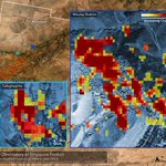
A damage proxy map for the M7.4 #TaiwanEarthquake on 3 Apr 2024. From #ALOS2 satellite #SAR data acquired 40 hours after the earthquake. We hope this map will support relief efforts. More maps and information at eos-rs-products.earthobserva…


EOS Remote Sensing retweeted

The International Postdoctoral Fellowship is a sponsored #fellowship with paid study leave of up to 2 years, before being appointed as a #tenure track Assistant Professor here!
Visit this link for more info:
ntu.edu.sg/science/research/…
#PhD #researchfellow #professorship #Research – at West Region, Singapore


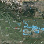
Our thoughts are with the people affected by the #flood in Libya. This flood proxy map is produced using #Sentinel1 #SAR data. The light blue pixels indicate areas that are likely flooded. More maps and information at eos-rs-products.earthobserva…

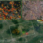
A damage proxy map for the M6.8 #earthquake that struck #Morocco on 8 Sep 2023. From #Sentinel1 satellite #SAR data acquired 56 hours after the earthquake. We hope this map will support relief efforts. More maps and information at eos-rs-products.earthobserva…

EOS Remote Sensing retweeted
Despite huge amounts of land use change and urban development, Singapore has over 390 recorded species of #birds, 2100 recorded species of #plants, and 100 species of reef #fish across the precious few #naturalhabitats left on our tiny island!
#ecology #wildlifeconservation – at Central Region, Singapore


EOS Remote Sensing retweeted

Tune in to CNA this coming Thursday to learn about our #sealevelrise and #disasterresponse research, which are some examples of how we promote more sustainable societies.
@SeaLevelNTU @eos_rs

#ClimateChange is reshaping our world. Watch how #NTUsg is leading the way in #sustainability across #education, #research, #innovation and community engagement in this new @ChannelNewsAsia #documentary #OurWorldtoChange. Premieres 20 July at 7:30pm on CNA.
EOS Remote Sensing retweeted
A pair of Spotted Wood #owls and their baby have been spotted around @NTUsg ! We get frequent visits from wildlife such as boars and pangolins! If you do spot any #wildlife just observe from safe distances and call @acres_sg or @EarthlinkNTU for any concerns!
#birdwatching – at West Region, Singapore


EOS Remote Sensing retweeted
The NAP provides opportunities for young #researchers and #scholars who aspire to a research leadership role within the fields of forest #ecology, #volcanology, or and #society
tinyurl.com/napntuase
Read what our faculty have to say about their experience working here:


EOS Remote Sensing retweeted

Please take a moment to check out our article on GNSS land subsidence observations along the northern coastline of Java, Indonesia.
nature.com/articles/s41597-0…

EOS Remote Sensing retweeted
The @EOS_RS team was hard at work! Trekking through ankle-grabbing vines and waist-deep canals in Brunei’s peatlands, it installed sensors for a project on carbon stocks.
#fieldwork #peatlands #carbonstock

Thanks to @straits_times for this nice article about our work! straitstimes.com/singapore/n… @NTUsg @EOS_SG @NTU_ASE @NTU_EEE @Sentinel_Asia @JAXA_en @WFP @NASA @esa

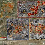
A damage proxy map for the M7.8 and M7.5 #earthquake that struck #Türkiye (#Turkey) and #Syria on 6 Feb 2023. From #ALOS2 satellite #SAR data acquired 2 days after the earthquakes. We hope this map will support relief efforts. More maps and information at eos-rs-products.earthobserva…

EOS Remote Sensing retweeted
We are #hiring! Join a dynamic and diverse group of Earth and Environmental Sciences enthusiasts as Full Professor.
Learn more and apply at ntu.wd3.myworkdayjobs.com/Ca…
@EOS_SG

EOS Remote Sensing retweeted
InVEST is a new programme led by Prof Emma Hill that will focus on the connections between earthquakes, volcanoes, tsunamis and landslides in Southeast Asia, to reduce the risks and impacts in the region. Learn more at bit.ly/InVEST_NewsPost
#InVEST_EOS


1/2 Please do stop by #AGU2022 on Monday morning Poster Hall A (McCormick South Level 3), GC12F-0497, to learn from Assoc Prof Sang-Ho Yun about our work on disaster response using remote sensing data!

1/2) A damage proxy map for surface change caused by #MaunaLoa volcano eruption in Hawaii that started on 27 Nov 2022. Produced from #alos2 satellite #sar data acquired on 29 Nov 2022. #MaunaLoaErupts

2/2) And an #insar map showing ground displacements for the #MounaLoa volcano eruption in Hawaii, from #alos2. More information and maps at eos-rs-products.earthobserva…
