

One-stop shop for in-depth forecast discussions and case studies for upcoming and past severe weather events across the United States.
Joined April 2022
- Tweets7.5K
- Following930
- Followers13.1K
- Likes15.1K




Some eye candy this morning as Super Typhoon Champi churns out in the Western Pacific. Once it completed an eyewall replacement cycle after its close pass to Guam, Champi reintensified into a monster, Category 5-equivalent storm, currently packing winds of over 160 mph and a central pressure of 919 mb.
Chase Archive Pro is now LIVE! Whether you're a storm chaser who enjoys documenting your chases in detail or a researcher looking for detailed meteorological information on past severe weather cases, I STRONGLY recommend you check out Chase Archive and sign up for the Pro tier. Chase Archive was already a gold mine of information on so many severe weather events past and present, and now they've added a bunch of awesome new features.
For just $5.99/month, you'll gain access to new tools and features including point soundings, expanded radar and satellite time ranges, dual-panel reflectivity and velocity data, and the ability to search for events based on a bunch of specific atmospheric parameters.
The first 20 subscribers get a founding member discount of $1 off per month, with the price at just $4.99/month as long as you remain subscribed.


Convective Chronicles retweeted

One of the best hurricane/typhoon datasets we may ever get. From its sharp turn to the northwest to the abundance of mesovortices and Vortex Rossby waves, along with an incredible 3D radar presentation, Super Typhoon #Champi will provide an incredible dataset for in-depth studies of powerful typhoons/hurricanes/cyclones going forward.
Some impressive satellite imagery of Typhoon Champi as it barrels toward Guam, packing winds of up to 140 mph with a minimum central pressure of 945 mb (equivalent to a Category 4). The hope is that Champi's tiny eye slides south of Guam, avoiding a direct hit.
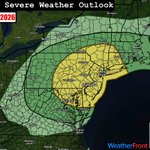
The severe weather threat shifts into the Mid-Atlantic/Northeast today, where SPC has outlined a Slight Risk (level 2/5), including places like New York City, Philadelphia, and Washington DC. A low-topped line of convection is expected to develop along an eastward-moving cold front, posing a risk for damaging winds. A tornado or two may also occur with line-embedded circulations.

As the rain begins to wind down, some pretty impressive 2-day observed rainfall totals are coming in across western and central Oklahoma from this system. The heaviest rainfall set up along the I-40 corridor, with Hinton tallying over 11" and El Reno over 10", but a broad swath of 2-3"+ totals occurred across the state. This should do wonders for Oklahoma's persistent drought, and while it won't nix the drought completely, we should see a lot less red on next week's drought monitor map.


A low-end severe weather risk is evident today across the Midwest. While the event hinges on adequate destabilization, which remains somewhat in question, a mix of supercells and clusters/line segments may develop across the Marginal (level 1/5) and Slight Risk (level 2/5) areas, posing a risk for isolated damaging wind gusts. The best chance for supercells appears to be across south-central Illinois and Indiana; should supercells develop, a tornado or two would also be possible.


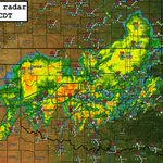
Along with today's severe threat, significant rainfall has fallen across Oklahoma since midnight, especially along the I-40 corridor, where totals are approaching 10" in spots (a whopping 9.20" at Hinton as of 10:30am CDT). A Moderate Risk (level 3/4) for excessive rainfall has been outlined by the WPC, several Flash Flood Warnings have been issued along this corridor, and multiple additional rounds of heavy rainfall are expected over the next couple days.


Widespread convection continues this morning across Oklahoma into parts of Texas. Areas to the south/southwest of this activity will have the best chance of destabilizing through the day, yielding another round of expansive strong to severe storms from southern Oklahoma into west Texas this afternoon into tonight. Quick upscale growth given weak capping and stronger forcing from the main trough ejection should yield mainly a damaging wind risk, but isolated large hail and a tornado or two are possible with any more robust semi-discrete storm or favorable portion within the line.


LINK: youtube.com/watch?v=ocLRej7b…
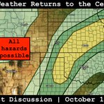
Forecast discussion on today's severe weather threat across the central/southern Plains. Strong/severe storms are expected to develop along a front and dryline this afternoon. While questions remain over the duration of any tornado threat, large hail and damaging winds will be the main risks.

Severe weather is set to return to the central/southern Plains Tuesday and Wednesday. A robust trough is forecast to move into the western US with broad southwesterly flow ahead of it. This should induce surface low development over the central High Plains on Tuesday, coincident with a tightening cold front and dryline.
Strong to severe storms, including supercells, are expected to develop along these boundaries Tuesday afternoon as a subtle disturbance ahead of the main trough ejects into the Plains. Large hail and damaging winds are the main threats, along with a low-end tornado risk from central Kansas into northwest Oklahoma. Relatively quick upscale growth is likely, especially along the cold front, which may start surging south with time.
On Wednesday, widespread convection may be ongoing through the morning into the afternoon. This adds uncertainty to the forecast, but where adequate destabilization can occur, another round of severe storms would be possible as the main trough ejects into the Plains.


An ongoing band of storms across the Carolinas has already warranted a few Severe Thunderstorm and Tornado Warnings this morning as it marches east-northeast. This should continue through the afternoon given tall/skinny but adequate instability profiles coupled with strong low-level shear. The expectation is that a slightly more favorable shear vector orientation with respect to the initiating confluence band and, thus, a more semi-discrete storm mode may evolve with time, increasing the threat for tornadic supercells. The greatest threat is expected to evolve over central North Carolina in the coming hours. A Slight Risk (level 2/5) and Tornado Watch have been issued for the area to cover this evolving threat.
Posted 9:30am CDT October 11, 2026


As Isaias completes its transition to an extratropical cyclone, the severe weather threat is expected to increase both today (Sat, Oct 10...focused on Georgia into South Carolina) and tomorrow (Sun, Oct 11...focused on North Carolina into Virginia).
Today, supercells should continue to increase in coverage through the morning/early afternoon across coastal areas of Georgia/South Carolina, spreading inland with time. For now, the airmass is more stable the farther inland you go due to widespread cloud cover and cooler temperatures, but through continued warm advection and filtered heating, some destabilization should occur. This should favor a tornado risk with any more robust supercell.
A repeat is expected tomorrow, just farther north into the Mid-Atlantic/Carolinas. A few supercells with a low-end tornado risk are possible as the atmosphere destabilizes into the afternoon.


Extreme low-level wind shear lies ahead of the bands of supercells making their way onshore in the Florida Panhandle this afternoon, as evidenced by the most recent VWP from the Tallahassee radar. Tornado potential will only increase from here on out, with a few intense tornado vortex signatures already observed over the Gulf.


Convective Chronicles retweeted

It's possible that the @NOAA_HurrHunter aircraft just measured the first solid evidence of vertical shear directly attacking the eyewall of Hurricane #Isaias. The last penetration measured an anomalous temperature spike at 750mb within the SW eyewall -—not within the eye—7C higher than the previously measured eye maximum.
This might be evidence of a rapidly descending flow belt caused by shear laterally forcing external air into the eyewall region, leading to a massive subsidence inversion. This is often observed in high-resolution modeling (see HAFS sounding from this morning's 06Z run). The dewpoint also sharply decreased concurrent with the temperature spike measured by aircraft, supporting the possibility that this phenomenon was observed.
This could foretell significant erosion of the southern eyewall in the near future, but time will tell. For now, Isaias remains as strong as ever according to the same aircraft data.


LINK: youtube.com/watch?v=FDUPnCjq…
Final forecast discussion on Isaias, which has intensified into a major, Category 3 hurricane overnight. The forecast remains generally on track, with a significant hurricane set to make landfall on the Gulf Coast later today, accompanied by a robust tornado risk near/east of the center.

LINK: youtube.com/watch?v=JOxhs-H6…
Updated forecast discussion on Hurricane Isaias, which continues to strengthen out in the Gulf. Isaias is expected to intensify further before weakening some on approach to the Gulf Coast tomorrow evening. In this video, we'll take a look at the latest observed and model data to refine out range of potential outcomes for Isaias.
