

Digital Helpers During Disasters to clarify, amplify, & inform. Not 24x7▪501c3▪❤/RT🚫endorsement https://xitter.cf/t.co/mvg3np6Rln https://xitter.cf/t.co/rD7U3cM6J6
United States
Joined September 2017
- Tweets48K
- Following912
- Followers7.2K
- Likes24.1K





Pinned Tweet
While we will continue posting here, we want to give you more ways to follow CEDR for updates if Twitter is out of service
Mastadon: universeodon.com/@CEDRdigita…
Facebook: facebook.com/CEDRdigital
Shelter Map, Cooling Center Map, and #FireMappers: cedrdigitalcorps.org/current…

CEDR Digital Corps retweeted

The @NWS expects the primary impacts from Francine to include heavy rain, high winds, & coastal flooding starting Tuesday night through Thursday morning.
⚠️ Finalize your storm prep by Tues. evening:
• Gather supplies
• Be ready to shelter in place
• Check on elderly neighbors


CEDR Digital Corps retweeted

If you don't have adequate access to air conditioning, here are links to cooling center resources for each of the counties we cover:
sandiegocounty.gov/content/s…
ocgov.com/cooling-centers
capriverside.org/cool-center…
dph.sbcounty.gov/extreme-hea…

#RailbridgeFire 🚨🚨EVACUATION ORDER🚨🚨
The Butte County Sheriff's Office is issuing an EVACUATION ORDER for the area of Crestmont Ct. in Zone 887 in Palermo due to a fire
For more information, including a map of the area buttecounty.net/sheriff
facebook.com/100044339323833…
#AeroFire #CalaverasCounty ⚠️⚠️Evacuation warning has been issued for east of Pool Station Road to Appaloosa and Bar 20.⚠️⚠️
zurl.co/0Q0k
#AeroFire #CalaverasCounty
🚨🚨Evacuation order has been issued from Rock Creek Road from Highway 4 to Hunts Valley Road and O’byrnes Ferry Road to Copper Cove and Highway 4 West to Copperopolis Town Square🚨🚨
zurl.co/TyuW
#AeroFire
Valley Springs Veterans Hall at 189 Pine Street for residents west of the town square. 🐶🐱Domestic animals can be taken to the Veterans Hall.
🐴🐄🐐Livestock can be taken to the Calaveras Fairgrounds
zurl.co/FnW3

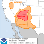
🚩🔥 Condiciones de #RedFlagWarning en AZ, UT, CO, NV y el norte de CA hoy. #FireMappers 🔥🚩
arcg.is/0iLbHL0
spc.noaa.gov/products/fire_w…


🚩🔥 #RedFlagWarning conditions across AZ, UT, CO, NV and northern CA today. #FireMappers 🔥🚩
arcg.is/0iLbHL0
spc.noaa.gov/products/fire_w…


🚩#RedFlagWarning is in effect for Eastern Lassen County today from 2 PM to 10 PM
🚩#RedFlagWarning is in effect for Northern Sacramento Valley, into Tehama and Glenn counties from Saturday evening through Monday afternoon. #CriticalFireWeather
zurl.co/f3hO

#NorthernCalifornia #NorCal #FireWx
🚩Red flag warning Saturday night into Sunday night. 🚩
🔥 #Sacramento Valley & adjacent foothills below 2000 ft late Sat night - Sun evening. #cawx
xitter.cf/NWSSacramento/status/1…

🔥 A Red Flag Warning has been issued for the majority of the Sacramento Valley & adjacent foothills below 2000 ft late Sat night - Sun evening. Gusty northerly winds + low humidity will lead to critical fire weather conditions. Practice fire weather safety! #cawx

ALT Red Flag Warning. A map on the right shows a Red Flag Warning for the majority of the Sacramento Valley and adjacent foothills below 2000 feet. Timing: 11 PM Saturday, June 15 – 8 PM Sunday, June 16, 2024. Forecast. Wind: North winds 10-20 MPH. Gusts 25-35 MPH. Daytime Humidities: 10-20%. Overnight Humidity Recovery: 30-40%. Impacts & Precautions. Easier fire starts & potential for rapid spread of fire. Fire safety precautions should be exercised to prevent fires. Always have an emergency plan for if a fire starts near you.
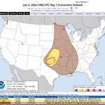
Qué: tormentas eléctricas severas con vientos dañinos, granizo grande, inundaciones y posibles tornados
Dónde: Medio Oeste y Sur con mayor riesgo en OK y la frontera AR-LA-TX
Más: @NWSNorman @NWSTulsa @NWSLittleRock @NWSWPC
spc.noaa.gov/products/outloo…
wpc.ncep.noaa.gov/qpf/ero.ph…


What: Severe thunderstorms w/damaging winds, large hail, flooding and potential tornados
Where: Midwest & South with highest risk for Oklahoma and AR-LA-TX border region
More info: @NWSNorman @NWSTulsa @NWSLittleRock @NWSWPC
spc.noaa.gov/products/outloo…
wpc.ncep.noaa.gov/qpf/ero.ph…


CEDR Digital Corps retweeted

#CorralFire Evacuation Update effective tonight, 6/2/24, at 6PM.
For the latest evacuation information go to sjready.org.
@SJC_OES @AlamedaCoFire

ALT Evacuation update document
#CorralFire #EvacuationOrder #EvacuationWarning #EvacuationMap
Official San Joaquin county OES evacuation map
app.perimeterplatform.com/in…
CEDR Digital Corps retweeted
#CorralFire [update] near Lawrence Livermore National Labratory Site 300 southwest of Tracy (San Joaquin County) is now 8800 acres and 10% contained. In unified command with @AlamedaCoFire #CALFIRESCU
EVACUATION information: sjready.org
@SJC_OES

ALT Incident update
CEDR Digital Corps retweeted

As of 6:27pm- Fire on Corral Hollow Rd E of I580. Residents in the area E of I/580 between Corral Hollow Rd and S Tracy Blvd should leave now. Residents S of Tracy Blvd should be ready to leave. @SJSheriff and @tracypd are assisting with evacuations in the area.
CEDR Digital Corps retweeted
Please follow their directions and leave if told to do so. A temporary evacuation site at Larch Clover Community Center - 11157 W Larch Rd, Tracy
CEDR Digital Corps retweeted
A partir de las 6:27pm Incendio en Corral Hollow Rd al este de la I580. Los residentes en el área al este de la I/580 entre Corral Hollow Rd y S Tracy Blvd deben evacuar ahora. Los residentes al sur de Tracy Blvd deben estar listos para evacuar.
CEDR Digital Corps retweeted
@SJSheriff y @tracypd están asistiendo con las evacuaciones en el área. Por favor, sigan sus instrucciones y evacúen si se les indica hacerlo. Se ha establecido un sitio de evacuación temporal en el Larch Clover Community Center - 11157 W Larch Rd, Tracy.
CEDR Digital Corps retweeted
SJC OES; EVACUATION ORDER, Wildfire on Corral Hollow Rd. LEAVE NOW. Check SJReady.org for information.