

Official City of Ann Arbor Government Twitter Site
- Tweets11.2K
- Following140
- Followers22.4K
- Likes263
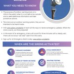






ALT This image features a graphic for the outdoor warning siren that will take place today at 1 p.m. It has icons and text highlighting tornado and wind warnings, hazmat materials and local emergency information. Sign up at www.a2gov.org/alerts to receive emergency updates.



ALT Over the last 24 hours, there has been a slight south shift in the area of concern for severe storms. There is still some concern that adequate instability will fail to lift into Southeast Michigan, which would reduce the severe weather risk. While some localized heavy rain is possible, more widespread heavy rain and flooding concerns have shifted south of the state line. The area of risk for strongest storms capable of producing damaging winds and tornaodes are locations along and south of an Ann Arbor to Detroit line. Actions to Take: Monitor the forecast and review your severe weather action plans

ALT There is a slight to marginal risk of severe weather across the southern half of the forecast area Thursday. At this stage in the forecast, there is still uncertainty as to how far north instability will reach. This will have a large impact on the northerly reach of the severe weather risk. Damaging winds to 60 MPH, Hail to 2 inches and isolated tornadoes are possible, with the greatest risk along and south of an Ann Arbor to Detroit line.

ALT The Road Home documentary flyer for the April 23, 2026, screening taking place 6 p.m. at the Michigan Theatre in Ann Arbor, exploring housing insecurities and homelessness in Washtenaw County. Free ticket reservations in advance using the QR code on the flyer

ALT The Road Home documentary flyer for the April 23, 2026, screening taking place 6 p.m. at the Michigan Theatre in Ann Arbor, exploring housing insecurities and homelessness in Washtenaw County. Free ticket reservations in advance using the QR code on the flyer


ALT Image of toothbrush, toilet, pipe, water droplet, and faucet. Text says, 'Turn off the water while brushing teeth. Replace high volume toilets with low volume toilets. Fix or replace all leaking faucets. Replace leaking appliances and fixtures. Replace outside home bibs with frost proof antisiphon well hydrants. EGLE logo in corner.'


ALT Ann Arbor City Clerk Jackie Beaudry at the podium in September 2025 during a city event at Larcom City Hall


ALT graphic that says "Voluntary Statewide Tornado Drill March 18, 2026 1:00pm"