

Chief Meteorologist for @cpsenergy. Former TV meteorologist in Victoria, Tyler, & San Antonio, Texas. My tweets/retweets are mine & not that of my employer.
San Antonio, TX
Joined August 2008
- Tweets33.9K
- Following2K
- Followers3.4K
- Likes3.4K




WIND GUSTS (10-16-26): As of 12pm, San Antonio Int'l Airport is reporting a 53 mph wind gust. That's the strongest wind gust reported in San Antonio so far today.

HELLO FALL: Cold front has arrived. Windy conditions will continue the rest of the day. Breezy winds through midday Saturday then winds will gradually decrease in the afternoon. Expect cool to chilly mornings with cool/mild afternoon temps.

Here is the latest information on the strong cold front just hours away.

🌬️ Weather Update
CPS Energy Chief Meteorologist @wxprobrian says a big cold front arrives early Friday, bringing a brief chance for showers before strong winds take over. Gusts could reach 40–50 mph through Friday afternoon and remain elevated into Saturday morning. Fire danger will also be high due to dry and windy conditions. Cooler temperatures follow for the weekend, with lows in the 50s and highs near 70°.
➡️ Stay weather aware and follow us for updates.
BIG CHANGES ON THE WAY: Get ready for a temperature roller coaster this week. Hot temperatures with heat indices near or slightly above 100° the next few days. A cold front arrives by Friday bringing a slight chance for showers, cooler temps, lower humidity and high winds.


MAJOR HURRICANE: As of 7:20am, Hurricane Isaias has stregthened into a major category 3 storm with sustained winds of 120 mph. Back on Tuesday, I told you this was a possibility and here it is. Landfall expected to occur later tonight.

ISAIAS: Formed this morning. No significant changes to the forecast. It is still expected to intensify to a hurricane in the next 24 hours. Texas is on the sinking side of this tropical system and only impact will be slightly higher temperatures.

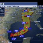
TRACKING THE TROPICS: Tropical Depression Nine has formed in the Gulf. This system will strengthen into this year's first hurricane of the season. It is not expected to impact Texas. It could potentially become a major category 3 hurricane prior to landfall.

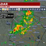
11AM (10-2-26): New Flood Advisory for Bexar county through 2pm. Rainfall estimates of 1-3" has fallen and more is expected.

8:17AM (10-2-26): Flood Advisory for Bexar county through 11am. Doppler radar estimates of 1-2" has fallen. More rainfall is possible over this area.

1:27PM (10-1-26): Flash Flood Warning issued for Bexar county until 7pm. Up to 2.5" has fallen in parts of the county and an additional 1-3" is possible.
FLOOD ADVISORY (10-1-26): NWS has issued a Flood Advisory for Bexar county through 3pm. Rainfall rates of 1-2" per hour with a brief spike to 3" an hour is possible.

10:22AM (10-1-26): Moderate to heavy rainfall is moving into Bexar county. Some of this rain could lead to isolated flash flooding. Stay weather aware the rest of this morning and afternoon.
Brian Alonzo retweeted

🌧️ WEATHER UPDATE (4 PM): We continue to monitor the potential for heavy rainfall and flash flooding across our service area. Our Chief Meteorologist @wxprobrian is providing the latest forecast and what to expect over the next several days as periods of heavy rain move through our area.
🔔 Stay weather-aware, have multiple ways to receive weather alerts, and be prepared for changing conditions.
🛑 Never attempt to drive through a flooded roadway. Turn Around, Don’t Drown!
📲 Enroll in our Energy Alerts at cpsenergy.com/alerts to receive emergency and outage notifications.
💡For the latest outage information, if needed, visit cpsenergy.com/outagemap and continue following CPS Energy on social media for updates.
⚠️ Stay away from downed power lines and always treat them as energized. Report downed power lines to 210-353-HELP (4357). Call 911 for an immediate life-safety emergency.
Our teams will continue monitoring conditions and are prepared to respond as needed.
FLOOD WATCH: Was just issued for South Central Texas. This does include the San Antonio area. This goes into effect starting Wednesday evening through Friday evening. Widespread 2-4" with isolated over 8" possible.

FLASH FLOODING LIKELY LATER THIS WEEK: Within the past hour the Weather Prediction Center has upgraded our flash flood threat to a Moderate Risk (4 out of 5). This does include the San Antonio area. The biggest day of concern will be on Thursday.


9:51PM (9-20-26): A few showers have developed along the I-35 corridor with the collision of two outflow boundaries. Lightning could be possible if the storms continue to intensify.
8:28PM (9-20-26): There are storms in the Hill Country that are slowly moving southeast. I'm going to be watching two outflow boundaries that could potentially ignite new thunderstorm activity in the San Antonio area within the hour. It's a wait and see situation.
2:09PM (9-18-26): Scattered showers and storms continue across San Antonio. Another area of storms is moving in from the southwest. Storms are not severe but brief locally heavy rain possible.