

Weather information you can trust. Degreed Meteorologist | Storm Chaser @msstate '26 & '28
Joined March 2026
- Tweets891
- Following205
- Followers1.6K
- Likes3.9K

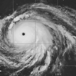




Can you guess which is Hurricane Katrina and which is Super Typhoon #Champi?


🚨Mikey Plemmons chased tornadoes in Brazil, and he is back to talk about it!
@TheNaderMike is joining the Mets for an exclusive 30-minute conversation about his trip to strom chase and spread severe weather awareness in Brazil.
Tune in TONIGHT on YouTube!
📅 Monday, October 19th, 2026
⏰ 7:00 PM CDT
📺 Live on YouTube, On-Demand after


CONGRATS!!!!! So much love for these two. Just incredible people.
Trying to keep my mouth shut was almost impossible 😭

I can’t even describe how much I love you @AngelaAlva45519 and I can’t wait to see what is next!
I can say with 100% certainty I would not be where I am today without having her by my side for the last 6 years.
Here is to many more tornadoes with you ❤️


Cooler temperatures are finally coming, but fire weather and a bit of severe weather are riding along with it. Tap into my latest forecast.
youtu.be/Nyr-ZCn53JM
Today's 2% #tornado risk in Illinois-Indiana screams 1 or 2 tornadoes in the year of Illinois (2026).
A few spinups possible along segmented cells, with the off-chance for a supercell that could plant one as well. Biggest fail mode pertains to cloud cover hindering instability.


The amount of surge foam that was leftover around this camera was insane.
Mark's equipment is just top notch. Dream come true to get to play a role in his mission with Hurricane #Isaias

Quick highlight reel from our remote cam that we placed on Santa Rosa Island just hours before Isaias made landfall.
The cam captured a lot of wave run-up and some surge but the overall water level did not get very high.
We also used some new tech to allow us to see better in the dark and also to collect surge data along with other wx data.
Will Bratton retweeted

My happy place... winds gusting to near 110mph
Inner eyewall of Hurricane Isaias near Fort Walton, FL
@willbrattonwx @floridamanwx
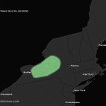
We also have a 2% #tornado risk reintroduced for western New York, which StormNet has been sniffing out for a few days now.
That one is much more conditional with less destabilization, but again, some potential.


The SPC has introduced a 5% #tornado risk zone for today's setup in the plains.
Still interested in a tornado or two in southern-central Kansas. Not the most robust setup, but has some potential.
We will be LIVE covering this event tonight!

The SPC has introduced a 5% #tornado risk zone for today's setup in the plains.
Still interested in a tornado or two in southern-central Kansas. Not the most robust setup, but has some potential.
We will be LIVE covering this event tonight!
Phenomenal work here, and no surprise given the person behind it
Matches parts of my original theory, corrects other parts, and fills in the gaps I still had question marks in.

Quick case study w/AI using HRRR operational data on the "sting jet" with Hurricane Isaias. I supplied a hypothesis based upon my old research.
Yes -- definitely a "sting jet" but origin not like intense extratropical cyclones -- intense air stream was in lower-levels and only dried / descended at very end of the road.
Call it --> "cold-conveyor-belt jet wrapped round the upshear side of a hurricane in extratropical transition, with a sting-jet-like descent at its end."
The trough decapitated the storm's PV tower, shearing it apart, then drying its west side, and forcing the descent. The trough did not supply the wind -- that was entirely the hurricane undergoing ET.
forecasteagle.com/cases/isai…


Monitoring the severe weather setup for tomorrow (Tuesday).
The SPC outlook funnily paints our old friend, the ridge, that has sat over the southeastern US for the majority of the last few months.
Risk for scattered damaging wind gusts, isolated hail, and a couple tornadoes tomorrow. Main limitation is weak forcing/instability. A couple triple-point tornadoes in central-southern Kansas wouldn't shock me.
We may go LIVE on YouTube to cover this event. Stay safe out there! #wx

Cool stuff here from Tim, a brief taste of what Hurricane #Isaias was like for us! We will also be producing a documentary on this intercept.

🚨My childhood idol legendary meteorologist Dave Murray joins Met Monday!
Dave is joining the Mets for an exclusive 30-minute conversation about his experiences in the meteorological space over the years across St. Louis, California, and the national scale! This is an especially exciting one for me.
Tune in TOMORROW on YouTube!
📅 Monday, October 12th, 2026
⏰ 7:00 PM CDT
📺 Live on YouTube, On-Demand after

Will Bratton retweeted

Small sample (15 mins) of wind data from our wx station that was placed on the Destin Bridge.
RM Young anemometer.
More to come next week.
@foxweather


Hey folks! Got well over 100 messages. We’re all okay!
- Intercepted the eye of Hurricane #Isaias as a high-end Category 2 at landfall just west of Destin, FL
- Aided in recovering @HurricaneTrack’s cameras
- Stayed in Destin with no power/service for the night
We’re headed to document some aftermath, likely to Pensacola later.
Stay safe out there!
