

Forest landscape ecologist @unito #LandscapeEcology #forests
- Tweets81
- Following289
- Followers196
- Likes396


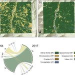




ALT Land-use/land-cover maps for 1954 (a) and 2017 (b). The chord diagram (c) shows the percentage between land-use/land-cover classes in 1954 (left) and 2017 (right). DF = dense forest, SF = sparse forest, WP = wood-pasture, Gr = grassland, Cr = cropland, Ur = urban, UV = unvegetated. Basemap powered by ESRI, ESRI standard.

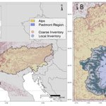
ALT Maps of the (a) Alps and (b) Piedmont Region with occurrences of the local (Camerano et al., 2017) and broad inventory (EU-Forest; Mauri et al., 2017).




ALT Drought stress analysis. Left: Edited plants after 10 days without water. Right: Control plants after 10 days without water.


ALT Principal component analysis at the municipality scale (s = 108) showing the correlation between anthropogenic variables and forest gain. Country centroids are shown as orange crosses: AT = Austria, CH = Switzerland, FR = France, IT = Italy, SI = Slovenia. Forest gain gradient is represented as a 3D response surface and contour lines obtained through non-parametric regression against PC1 and PC2 scores. Flexibility was optimized according to the highest cross-validated fit (xR2).


