

Storm Chaser 🌪️ Photojournalist 📸 🎥 Environmental Scientist 🔬 Capturing nature’s fury since 2008📍NC // Carolina Weather Group
Greensboro, NC
Joined October 2014
- Tweets1.4K
- Following232
- Followers4.9K
- Likes2.2K




Dan Whittaker retweeted

Here's a map of the 13 confirmed tornadoes from Sunday in North Carolina.
Remnant spin and moisture made for a ripe environment to produce these storms, especially in Central NC.
3 were EF-2 (110+ mph), 5 EF-1 (85+ mph), and 5 EF-0 (65+ mph).

Hurricane Isaias landfall at Destin Florida! Clips filmed tonight between Destin and Fort Walton Beach #hurricane
Fort Walton Beach Florida right now as Hurricane Isaias makes aim for landfall #hurricane
Oof

If you are thinking this Hurricane Season is slow, it is. Very slow. Actually record breaking slow! In all prior years we have seen our first Hurricane by this date (since satellite era 1960). Crazy to think. Every year since 1960 has had a Hurricane in the Atlantic by September 11th. It is a good record to be broken for sure! And nothing is showing on the horizon any time soon. We can thank this big ol' El Nino for this.

Saw some of the big GA, SC, and NC storms from the sky today on the way to Greensboro from ATL. What a perspective! This short timelapse shows the descent into ATL where the height of the clouds can be observed
Congrats to Tommy pulling a needle out of a haystack from the storm we were in a couple days ago. He was the only one of us at the time running drone video and he found this when we all went back to compare time stamps! NC teamwork 👏

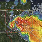
Brief 15x timelapse of a #tornado over NW Chapel Hill, NC on 7/28/26 (8:13–8:20 PM EDT).
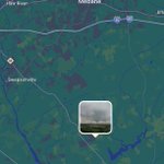
Filmed from SW at the Chapel Hill American Legion. Radar loop & my position (pink) attached.
Big thanks to @severeforecast & Meteorologist Jeremy Gilchrist for helping verify my likely 2nd EF-U if @NWSRaleigh agrees!
#ncwx #wxtwitter


Dan Whittaker retweeted
Another look at the rotation on the storm in Burlington yesterday evening.
You're seeing what we call a "mesocyclone" - basically a thunderstorm that is rotating on its own, often capable to produce a tornado.
In this case, while some funnels were spotted it doesn't seem like any significant touchdowns occurred. Lack of widespread damage.
This was from our @WFMY camera in downtown Burlington, which we brought you live during coverage.
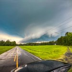
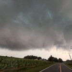
Going through some pictures from the long-lived supercell that I saw from Mayodan into Chapel Hill NC. Tornado warned for quite some time. Ran into some NC storm chasers that I hadn’t seen in quite some time! The skies were robust, and the back roads of NC were beautiful!


Dan Whittaker retweeted

Tornado warned storm over Burlington, NC tonight. What a day this was. @TimBuckleyWX @severeforecast @ChaserDeniro @NcScStrmChasers

Finishing off the chase now near Chapel Hill NC. I was on that storm directly underneath the radar area of rotation for a full three hours, most of that time being tornado warned & at times showing signs of decent visible rotation. Quite the storm day as far as NC is concerned!


Beautiful and ominous colors at Mattoon/Charleston Illinois storm as a rain wrapped tornado resulted in EF-2 damage. I caught a view of the tornado before it was fully obscured by rain, which caused a damage path stretching through the east side of Charleston. An intense blob of rain-nado that I had to eventually avoid! The color on this storm was particularly gorgeous!


Approaching the rain wrapped tornado north of Charleston Illinois last night called for some split second decisions. I saw the tornado for a minute before it went rain wrapped and then I was able to stay ahead by going *northeast* 👀 and then an eventual dash south! Road networks were unforgiving and so I stuck to gravel roads!

