
WOOD TV Meteorologist, Former KCAU Chief Met, AMS CBM #865, Valpo graduate, 17 year GameStop employee, BSA Eagle Scout, Radiohead fan, dad to Pippa & Duncan
- Tweets7.9K
- Following342
- Followers854
- Likes420




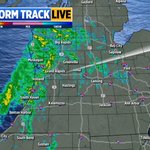








ALT Accumulating snow likely Saturday Night into Monday Morning. Snow begins near the lakeshore late Saturday evening, expanding across west Michigan Sunday, diminishing Monday Morning. Highest snow totals across western portions of Allegan, Mason, Oceana, and Van Buren Counties, 4-7” of snow expected with isolated higher totals possible. Accumulations across the rest of West Michigan limited to 2” of snow or less. Gusts to 35 mph support patchy blowing snow, mainly near US-31, reducing visibility in heavier snow bands. Plan for slick roads, travel delays, and rapidly changing road conditions and visibilities.


ALT Sneaky Winter Hazards. The winter season bring many weather events that can "sneak" up on you. These are weather hazards that cause big impacts and make travel difficult. Dense fog, fog can be hazardous to drivers, mariners, and aviators and contributes to thousands of travel accidents every year. Visibility often changes quickly in fog. Safety Tips, slow down, use your low-beam headlights, leave plenty of distance between you and other vehicles.

ALT Ice Jam Threat through this weekend. Be alert for ice jams and possible flooding near rivers. What to expect. Rising rivers this week will likely cause remaining river ice to break and move. Localized rapid water rises may occur with little to no notice. What you should do. Check river observations and forecasts at water.noaa.gov. Those along rivers should prepare for rising water and potential ice jams. Help us out! Take a picture of a river near you and put it along with your location in the comments.