

Earth Observation company. We use satellite data to answer questions about our planet's behaviour - we also produce some interesting images!
Plymouth, UK
Joined April 2012
- Tweets5.6K
- Following2.6K
- Followers2.7K
- Likes1.6K


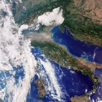



First light images from Sentinel-3C's Ocean and Land Colour Imager (OLCI) were released last week and included images of Italy, Canadian Arctic Archipelago, Caribbean, and sea surface heights across the Atlantic. buff.ly/vTQ0gAo #EarthObservation

First light images have been released from both Sentinel-3C and the latest IRIDE Eaglet II #satellites over the last week. Images include Italy, Canadian Arctic Archipelago, Caribbean, and Gibraltar. buff.ly/vTQ0gAo #EarthObservation

First light image from the latest batch of Italy's IRIDE Eaglet II #satellites has been released, showing the UK territory of Gibraltar. The IRIDE Eaglet II constellation comprises of 24 satellites. buff.ly/vTQ0gAo #EarthObservation

First light images from Sentinel-3C's Ocean and Land Colour Imager (OLCI) were released last week and included images of Italy, Canadian Arctic Archipelago, Caribbean, and sea surface heights across the Atlantic. buff.ly/vTQ0gAo #EarthObservation

First light images have been released from both Sentinel-3C and the latest IRIDE Eaglet II #satellites over the last week. Images include Italy, Canadian Arctic Archipelago, Caribbean, and Gibraltar. buff.ly/vTQ0gAo #EarthObservation

The Suncatcher M1 satellite for Google has been launched recently, its an experimental mission testing how computer AI chips operate in #space, the firt phase of putting solar powered data centres into orbit. The outcome is worth monitoring. buff.ly/ytUeMQV

Latest SpaceX rideshare put a variety #EarthObservation #satellites into #space including several methane monitoring satellites: two for GHGSat and one for Carbon Mapper; and two thermal satellites HotSat-3 for SatVu and FOREST-20 for OraraTech. buff.ly/ytUeMQV

Latest SpaceX rideshare launch put an experimental satellite into orbit for Google to test how computer chips cope with the space environment, plus a variety of exciting new #EarthObservation missions. buff.ly/ytUeMQV #space

Suncatcher M1 satellite was launched for Google last week, it's part of thier moonshot programme to scale maching learning in space. Onboard are four custom AI chips that can power Google Gemini for 15 minutes to test how it operates in space. buff.ly/ytUeMQV #space

Latest SpaceX rideshare put a variety #EarthObservation #satellites into #space including 8 x Eaglet II multispectral satellites for Italy's IRIDE programme, Altair for the UAE with mutiple sensors on it, 3 x MikroGLOB satellits for Poland's military. buff.ly/ytUeMQV

Latest SpaceX rideshare launch put an experimental satellite into orbit for Google to test how computer chips cope with the space environment, plus a variety of exciting new #EarthObservation missions. buff.ly/ytUeMQV #space

Did you know that 30 of the United Nations 232 Sustainable Development Goals can only be monitored using satellite #EarthObservation data? The UN bescribes EO data as providing both indirect and indirect contributions to achieving the goals buff.ly/xL0UF8U

Two bodies of the United Nations are this week calling on governments, regulators, and meteorologists to safeguard access to radio frequency spectrum essential for #EarthObservation. buff.ly/xL0UF8U

This week two bodies of the United Nations are this week calling on governments, regulators, and meteorologists to safeguard access to radio frequency spectrum essential for Earth Observation. buff.ly/xL0UF8U

Did you know that 30 of the United Nations 232 Sustainable Development Goals can only be monitored using satellite #EarthObservation data? The UN bescribes EO data as providing both indirect and indirect contributions to achieving the goals buff.ly/xL0UF8U

At the start of United Nations Global ITU-WMO Seminar, the two bodies of the United Nations are this week calling on governments, regulators, and meteorologists to safeguard access to radio frequency spectrum essential for Earth Observation. buff.ly/xL0UF8U

This week two bodies of the United Nations are calling on governments, regulators, and meteorologists to safeguard access to radio frequency spectrum essential for #EarthObservation, to ensure datasets can be protected. buff.ly/xL0UF8U

Recent SPIE Sensors + Imaging 2026 conference in Edinburgh was a great a opportunity to see the innovation and cutting edge developments in #RemoteSensing. If you missed it, the 2027 event takes place in Stockholm in September. We'll be there, will you? buff.ly/T1Jz66L

Highlights of last week's SPIE Sensors + Imaging 2026 conference that took place in Edinburgh, with a focus on the Environmental Remote Sensing talks. Pixalytics gave one presentation and jointly gave a second. buff.ly/T1Jz66L

Last week's SPIE Sensors + Imaging 2026 conference had talks on using #RemoteSensing to study Lake Garda, importance of in-situ sampling, seagrass mapping in Sweden, and impacts of melting Arctic and Greenland sea-ice, amongst many others. buff.ly/T1Jz66
