

kenjiro totsuji's map / gis / visualization things. Otherwise: @kenjirototsuji 地図など。
tokyo
Joined March 2014
- Tweets46
- Following0
- Followers222
- Likes4





paragram retweeted

Tour de France Stage 5
Lannemezan > Pau
Flat 158.3 km
Live weather along today’s route
bikeracemaps.com/race/2026-t…
Live tracking will start after the official start
#jspocycle #TDF2026


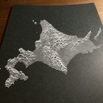
unknown hokkaido
PyQGIS, vpype, xyplotter, white ballpoint pen, black cardboard
#plottertwitter #QGIS #map #cartography


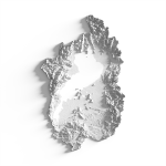
LiDAR-esque modeling from
- dem
- forest area
- surface water
- building footprint
- railway line
#cartography #geography #map #gis #qgis #b3d


Nagasaki 1945
U.S. Army Map Service, Japan City Plans. 1:12,500
旧米国陸軍地図局 1万2500分の1「長崎」昭和20年
国土地理院基板地図情報5mメッシュ数値標高モデル
(repost with adjustment)
#cartography #geography #map #gis #qgis #b3d
