

Do not use this platform to request assistance. Call 132 500 for emergency help in floods and storms. Call 000 for life-threatening emergencies. #NSWSES
NSW
Joined November 2010
- Tweets11.9K
- Following237
- Followers88.9K
- Likes1.3K



Were you impacted by the storms last night? Our volunteers have been busy responding to 300 calls for assistance across the state, including significant damage impacting South West Rocks and Singleton.
The thunderstorms caused incidents such as multiple lost and leaking roofs, trees down and damage to property 🏚️
Our volunteers have been deployed to Mudgee to assist with clean up after a hail storm damaged buildings.
This weather isn’t unusual for this time of year and there’s very likely more to come, with storm season hanging around until April next year ☔️
📲 Make sure you stay ahead of the storm and monitor the Hazards Near Me app to be prepared for the next one!


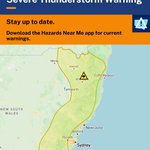
A Severe Thunderstorm Warning for DAMAGING WINDS, LARGE HAILSTONES and HEAVY RAINFALL has been issued by the Bureau of Meteorology 🍃
📍Residents in parts of the Mid North Coast, Hunter, Central Tablelands, North West Slopes and Plains and Northern Tablelands Forecast Districts should monitor conditions and follow safety advice.
A humid airmass combines with a trough and upper disturbance to destabilise the atmosphere, resulting in an area of thunderstorms across the Central Tablelands and upper Hunter, extending to northeast northeastern NSW during the afternoon.
📲 Download Hazards Near Me or visit our website to stay up to date with warnings and information, especially as the weather moves through and may affect other locations.
Stay ahead of the storm:
🔸Move your car under cover or away from trees and powerlines if safe to do so.
🔸Secure or put away loose items around your house, yard and balcony.
🔸Keep clear of creeks and storm drains.
🔸Report fallen power lines to either Ausgrid (131 388), Endeavour Energy (131 003), Essential Energy (132 080) or Evoenergy (131 093) as shown on your power bill.
🚫 Steer clear of flooded roads - if you come across one, turn around and find an alternative route. Remember that flash flooding is dangerous and unpredictable.
📞 If you require assistance in floods and storms, call the NSW SES on 132 500. In life-threatening situations, call Triple Zero (000).
Issued at 12:27 pm EDT on Monday 16 November 2026
Full warning: bom.gov.au/warning/severe-th…

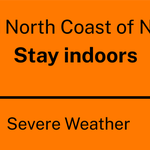
NSW SES is advising people in the following area(s) to STAY INDOORS due to destructive winds, giant hailstones:
- Forster
- Seal Rocks
WATCH AND ACT
Next update: Sunday 15 Nov 5:30 pm
Find out more: hazardwatch.gov.au/a/9T5pzu
#NSWSES


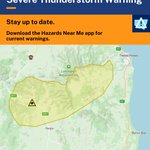
A Severe Thunderstorm Warning for DAMAGING WINDS, LARGE HAILSTONES and HEAVY RAINFALL has been issued by the Bureau of Meteorology 🍃.
📍Residents in Northern Rivers and parts of Mid North Coast and Northern Tablelands Forecast Districts should monitor conditions and follow safety advice.
Severe thunderstorms are likely to produce damaging winds, large hailstones and heavy rainfall that may lead to flash flooding in the warning area over the next several hours. Locations which may be affected include Lismore, Grafton, Kyogle, Tabulam, Urbenville and Jackadgery.
📲 Download Hazards Near Me or visit the NSW SES website to stay up to date with warnings and information.
Stay ahead of the storm:
🔸Move your car under cover or away from trees and powerlines if safe to do so.
🔸Secure or put away loose items around your house, yard and balcony.
🔸Keep clear of creeks and storm drains.
🔸Report fallen power lines to either Ausgrid (131 388), Endeavour Energy (131 003), Essential Energy (132 080) or Evoenergy (131 093) as shown on your power bill.
🚫 Steer clear of flooded roads - if you come across one, turn around and find an alternative route. Remember that flash flooding is dangerous and unpredictable.
📞 If you require assistance in floods and storms, call the NSW SES on 132 500. In life-threatening situations, call Triple Zero (000).
Issued at 1:09 pm EDT on Thursday 12 November 2026.
View Warning: bom.gov.au/warning/severe-th…

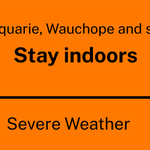
NSW SES is advising people in the following area(s) to STAY INDOORS due to heavy rainfall with flash flooding possible, damaging winds, giant hailstones:
- Port Macquarie
- Wauchope
WATCH AND ACT
Find out more: hazardwatch.gov.au/a/5I1rdm
#NSWSES


A Severe Thunderstorm Warning for DAMAGING WINDS and LARGE HAILSTONES has been issued by the Bureau of Meteorology 🍃.
📍Residents in Northern Rivers District should monitor conditions and follow safety advice.
Locations which may be affected include Murwillumbah, Numinbah, Tyalgum and Wiangaree.
📲 Download Hazards Near Me or visit the NSW SES website to stay up to date with warnings and information, especially as the weather moves through and may affect other locations.
Stay ahead of the storm:
🔸Move your car under cover or away from trees and powerlines if safe to do so.
🔸Secure or put away loose items around your house, yard and balcony.
🔸Report fallen power lines to either Ausgrid (131 388), Endeavour Energy (131 003), Essential Energy (132 080) or Evoenergy (131 093) as shown on your power bill.
Prepare early. Stay informed. Act safely.
📞 If you require assistance in floods and storms, call the NSW SES on 132 500. In life-threatening situations, call Triple Zero (000).
Issued at 2:13 pm EDT on Wednesday 11 November 2026
Full warning: bom.gov.au/warning/severe-th…

A Severe Thunderstorm Warning for DAMAGING, LOCALLY DESTRUCTIVE WINDS, LARGE, POSSIBLY GIANT HAILSTONES and HEAVY RAINFALL has been issued by the Bureau of Meteorology ☔️
📍 Residents in the Mid North Coast, Hunter, Illawarra, Northern Tablelands and parts of Northern Rivers, Metropolitan, Central Tablelands, Southern Tablelands, North West Slopes and Plains, South West Slopes and South Coast Forecast Districts.
GIANT HAIL AND DESTRUCTIVE WINDS POSSIBLE IN NORTHERN NSW.
A very moist and unstable environment conducive to rapid severe thunderstorm development is set up throughout eastern NSW and southeastern Qld.
📲 Download Hazards Near Me or visit the NSW SES website to stay up to date with warnings and information, especially as the weather moves through and may affect other locations.
Stay ahead of the storm:
🔸 Move your car under cover or away from trees and powerlines if safe to do so.
🔸 Tie down loose items in your yard, if safe to do so.
🔸 Report fallen power lines to either Ausgrid (131 388), Endeavour Energy (131 003), Essential Energy (132 080) or Evoenergy (131 093) as shown on your power bill.
Prepare early. Stay informed. Act safely.
🚫 Steer clear of flooded roads - if you come across one, turn around and find an alternative route.
Remember that flash flooding is dangerous and unpredictable.
📞 If you require assistance in floods and storms, call the NSW SES on 132 500. In life-threatening situations, call Triple Zero (000).
Issued at 3:16 pm Tuesday, 3 November 2026.
View full warning: reg.bom.gov.au/products/IDN2…

A Severe Thunderstorm Warning for DAMAGING WINDS, LARGE HAILSTONES and HEAVY RAINFALL has been issued by the Bureau of Meteorology ☔️
🏡 Residents in parts of the Mid North Coast, Hunter, North West Slopes and Plains, Northern and Central Tablelands Forecast Districts should monitor conditions and follow safety advice.
Severe thunderstorms are beginning to develop through northeastern NSW, which are likely to produce damaging winds, large hailstones and heavy rainfall that may lead to flash flooding in the warning area over the next several hours.
📲 Download Hazards Near Me or visit the NSW SES website to stay up to date with warnings and information, especially as the weather moves through and may affect other locations.
Stay ahead of the storm:
🔸 Move your car under cover or away from trees and powerlines if safe to do so.
🔸 Tie down loose items in your yard, if safe to do so.
🔸 Report fallen power lines to either Ausgrid (131 388), Endeavour Energy (131 003), Essential Energy (132 080) or Evoenergy (131 093) as shown on your power bill.
Prepare early. Stay informed. Act safely.
🚫 Steer clear of flooded roads - if you come across one, turn around and find an alternative route.
Remember that flash flooding is dangerous and unpredictable.
📞 If you require assistance in floods and storms, call the NSW SES on 132 500. In life-threatening situations, call Triple Zero (000).
Issued at 12:48 pm EDT on Tuesday 3 November 2026

⚠️ UPDATE 2:46PM: This warning is now for people in Hunter, Illawarra, Central Tablelands, Northern Tablelands and parts of Northern Rivers, Mid North Coast, Metropolitan, Southern Tablelands, North West Slopes and Plains and South West Slopes Forecast Districts.
Severe thunderstorms continue to develop through eastern NSW.
A very moist and unstable environment conducive to rapid severe thunderstorm development is set up throughout eastern NSW and southeastern Qld.
NSW SES retweeted

⚠️⛈️Severe thunderstorms developing about the northeast, and approaching the southern #Riverina.
Locations that could be affected #Dorrigo #Woodenbong #Baryulgil #Jackadgery #Copmanhurst and #CouttsCrossing.
Details: bom.gov.au/warning/severe-th…

NSW SES retweeted
⛈️#NSW Thunderstorm forecast 1 Nov
🟢Storms possible across eastern and northern NSW.
🟡Severe storms are possible in the Hunter and northeast. Possible hazards are large hail, damaging winds, and heavy rainfall.
bom.gov.au/location/australi…

Severe thunderstorms are expected again this afternoon, following a weekend of wild weather 🌪️⛈️
We received 140 incidents across NSW over the past few days, with a supercell thunderstorm near Yass causing significant damage including fallen trees and roof removals.
Our volunteers, alongside our friends at @NSWRFS, have worked tirelessly to complete clean up tasks, welfare checks and roof tarping.
⚠️ For the week ahead, there’s a possibility of severe thunderstorms in the Northeast and Southwest of the state today.
Thunderstorms are possible again in the Northeast tomorrow with severe storms likely as well.
Wednesday is likely to see showers and thunderstorms in southern inland areas.
📲 Ensure you keep across warnings and information with the Hazards Near Me app and make sure you stay ahead of the storm by preparing your home.
☎️ If you require assistance, give us a call on 132 500. In life-threatening emergencies, call Triple Zero (000)
📸 - NSW SES Yass Unit & NSW RFS Southern Tablelands Zone


NSW SES retweeted

Severe Weather Update: Further severe thunderstorms for Queensland and New South Wales.
Video current: 1:00pm AEDT 26 October 2026.
Latest forecasts and warnings: bom.gov.au or the BOM Weather app.
A Severe Thunderstorm Warning for LARGE HAILSTONES, HEAVY RAINFALL and DAMAGING WINDS has been issued by the Bureau of Meteorology ☔️
📍 Residents in parts of the Mid North Coast and parts of Hunter, Northern Tablelands, Northern Rivers and North West Slopes and Plains Forecast Districts should monitor conditions and follow safety advice.
Severe thunderstorms are developing along an inland trough and a southerly change is moving north across the northeast this afternoon.
📲 Download Hazards Near Me or visit the NSW SES website to stay up to date with warnings and information, especially as the weather moves through and may affect other locations.
Stay ahead of the storm:
🔸 Move your car under cover or away from trees and powerlines if safe to do so.
🔸 Tie down loose items in your yard.
🔸 Report fallen power lines to either Ausgrid (131 388), Endeavour Energy (131 003), Essential Energy (132 080) or Evoenergy (131 093) as shown on your power bill.
Prepare early. Stay informed. Act safely.
🚫 Steer clear of flooded roads, if you come across one, turn around and find an alternative route. Remember that flash flooding is dangerous and unpredictable.
📞 If you require assistance in floods and storms, call the NSW SES on 132 500. In life-threatening situations, call Triple Zero (000).
Issued at 1:28 pm EDT on Monday 26 October 2026
Full warning: bom.gov.au/warning/severe-th…
