

Do not use this platform to request assistance. Call 132 500 for emergency help in floods and storms. Call 000 for life-threatening emergencies. #NSWSES
NSW
Joined November 2010
- Tweets11.9K
- Following236
- Followers88.9K
- Likes1.3K


NSW SES retweeted

Powerful storms have developed around Penrith and Richmond in the west, and parts of the Blue Mountains. Heavy Rain, Damaging Wind and Large Hail possible in the next hour or two.
Full details: bom.gov.au/warning/severe-th…

NSW SES retweeted
⚠️🌬️9:25am:Severe Weather Warning for damaging #winds for Illawarra and parts of South Coast, Central Tablelands, Southern Tablelands, South West Slopes, and Snowy Mountains.
Damaging winds developing in the southeast on Saturday.
ow.ly/7yuB50ZJ3fz

NSW SES retweeted
⚠️🌬️Severe Weather Warning for damaging #winds along #GreatDividingRange, extending to coastal areas around #Newcastle #Wollongong.
May affect #Armidale #Goulburn #Nowra #Scone #Katoomba #Cessnock #Maitland #Bowral #Braidwood #Dorrigo #ThredboTopStation.
bom.gov.au/warning/severe-we…

NSW SES retweeted
⚠️🌬️ 5:13am: Severe Weather Warning for damaging winds current in #NSW during Friday for:
- Alpine peaks above 1900m (peak gusts of 100km/h likely)
- Inland parts of the #NSW South Coast & Illawarra (peak gusts up to 90km/h possible)
Details: bom.gov.au/warning/severe-we…

NSW SES retweeted
⚠️Severe Weather Warning for DAMAGING WINDS⚠️
Damaging winds to develop on Wednesday evening for alpine areas.
More: bom.gov.au/
#MountGinini #Thredbo #Tidbinbilla #PerisherValley

NSW SES retweeted
⚠️⛈️ 8:25am: Severe Thunderstorm Warning for heavy #rainfall in parts of Lower Western and Upper Western Forecast Districts.
Locations which may be affected include #BrokenHill, #Wilcannia, #WhiteCliffs, #Menindee and #FowlersGap.
Details: bom.gov.au/warning/severe-th…

NSW SES retweeted
⚠️🌬️Severe Weather Warning for Damaging Winds, Thurs 4 June
Damaging wind gusts to 90 km/h or more possible about southern and central ranges today, extending to the #Illawarra Coast and northern ranges this evening.
bom.gov.au/warning/severe-we…

NSW SES retweeted

Severe Weather Update: More severe storms and heavy rain for the east
Video current: 2pm AEST 28 May 2026
Latest forecasts and warnings: bom.gov.au or the BOM Weather app.
NSW SES retweeted
⚠️⛈️Severe Thunderstorm Warning for HEAVY RAINFALL and DAMAGING WINDS
parts of Mid North Coast, Hunter, North West Slopes and Plains, Central Tablelands and Central West Slopes and Plains
Severe storms affecting parts of the central east and northeast
bom.gov.au/warning/severe-th…

NSW SES retweeted
Scattered showers about the coast and ranges, extending into the western slopes and plains. Showers and storms about the far west. Chance of a shower elsewhere. Day-time temperatures mostly above average, below in the west. Hazardous surf about the coast.
bom.gov.au/location/australi…

NSW SES retweeted

Happy Wear Orange Wednesday (WOW DAY) to our friends from @NSWSES. 🧡🟠🧡
Thanks for all you do. Always a pleasure working with you!
#lifesaverhelo #wowday


NSW SES retweeted
⚠️🌬️ 10:54am AEST: Severe Weather Warning for Damaging Winds for parts of the South Coast, Southern Tablelands & Snowy Mountains of #NSW.
Northwesterly winds with peak gusts around 100km/h are possible later Thurs and into Fri.
Details: bom.gov.au/warning/severe-we…

NSW SES retweeted
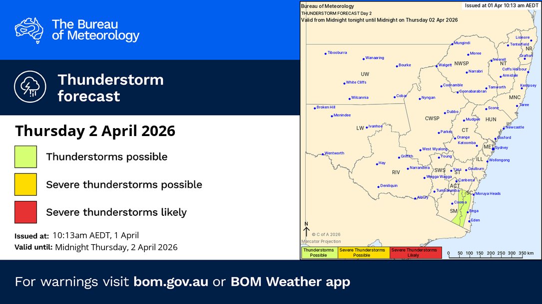
Thunderstorm FORECAST Thursday (2/4):
🟢Thunderstorms are possible across the southeast coastal ranges, most likely during the afternoon.
Forecasts and warnings: bom.gov.au/location/australi…
NSW SES retweeted
⛈️Thunderstorm FORECAST for FRIDAY 27/3:
🟡Severe storms possible: Illawarra, South coast and parts of the Snowy Mountains
Hazards: Damaging winds
🟢Non-severe storms possible: Hunter coastal fringe through to the southern ranges
Forecast and warnings: bom.gov.au/location/australi…

NSW SES retweeted
⛈️Thunderstorm FORECAST 26/3:
🔴Severe storms likely: parts of #Sydney Metropolitan, #Illawarra, Southern and Central Tablelands
🟡Severe storms possible: central and southeast #NSW
Hazards: Damaging winds, large hail and heavy rainfall
Warnings: bom.gov.au/weather-and-clima…

NSW SES retweeted
⚠️🌬️ 10:53am: Severe Weather Warning for DAMAGING WINDS for the #SouthCoast, #SnowyMountains, #ACT and parts of #Metropolitan, #Illawarra, #SouthernTablelands and #SouthWestSlopes.
DAMAGING WIND GUSTS are likely to develop from Friday morning.
Details: bom.gov.au/warning/severe-we…

NSW SES retweeted
⛈️Thunderstorm FORECAST for TODAY (25/3):
🟡 Severe storms possible: parts of the #SnowyMountains and #SouthCoast
Hazards: Damaging winds, large hail and heavy rainfall
🟢 Non-severe storms possible: southern and eastern #NSW
Warnings if required: bom.gov.au/weather-and-clima…

NSW SES retweeted
⚠️⛈️ 7:51am: Severe Thunderstorm Warning for heavy #rainfall in parts of Northern Rivers Forecast District.
Locations which may be affected include #ByronBay, #Ballina, #Mullumbimby, #Alstonville and #BrunswickHeads.
bom.gov.au/warning/severe-th…

NSW SES retweeted
Today's Thunderstorm FORECAST
Severe thunderstorms are likely in the far northwest.
Severe thunderstorms are possible on the southern and central ranges, southern slopes, and eastern Riverina.
Heavy rainfall is a concern.
More: bom.gov.au/

NSW SES retweeted
⚠️🌧️Severe Weather Warning
Issued at 4:59 am AEDT
Areas of heavy #rainfall persisting about the northwest.
May affect #Tibooburra, #WhiteCliffs, #Wanaaring, #Louth, #Tilpa, #Milparinka.
bom.gov.au/warning/severe-we…
