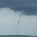
Water spout of the coast of Long Key just a few minutes ago. @CBSMiami @LaurenPastrana
We packed the room a few weeks ago to warn elected officials how dangerous Clements Ferry Road has become. Another shutdown at Marina Dr this morning. We need action.
TRAVELALERT:
Watch out for a crash on Clements Ferry Road near Marina Drive, close to I-526. Traffic is backed up on I -526 eastbound and westbound at the Clements Ferry interchange.
1. Both lanes are closed on Clements Ferry Road near Marina Drive towards Highway 41.
2. Traffic is merging and going around using the median.
3. Several vehicles at the scene and a tractor trailer. A motorcycle is under the tractor trailer.
@ABCNews4
Grateful for the partnership of @CCSDConnects @ChasCoSheriff working with @ChasCoLibrary to feed families this holiday season. #chs #chsnews
Natalie Caula Hauff retweeted
🌀 Social Media ≠ Official Forecasts
As tropical storms approach, misinformation spreads fast.
✅ Use official sources
⚠️ Models ≠ forecasts
🧠 Think before you share
Follow @NWSCharlestonSC and @NHC_Atlantic for updates.

ALT Get your information from trusted sources like the National Weather Service (NWS), National Hurricane Center (NHC), or local meteorologists. If a storm threatens southeast South Carolina or southeast Georgia, you can count on us to be posting about it. Model graphics online often lack context and are not official forecasts. The only forecast you should rely on comes from the National Hurricane Center. Anyone can create or post weather graphics online, and some are designed to be misleading or overly dramatic. Sharing unofficial or inaccurate information can cause unnecessary fear and confusion. Always check the source before spreading weather-related content.
Natalie Caula Hauff retweeted
There have been many reports of a #fireball streaking across the southeastern U.S. this afternoon! The Geostationary Lightning Mapper (#GLM) on @NOAA's #GOES satellites can occasionally detect these bright meteors (aka #bolides) when they pass through the atmosphere.
See the quick flash #GOESEast captured around the Virginia/North Carolina border today. #GOES19
Natalie Caula Hauff retweeted
Natalie Hauff sent me this awesome picture of the shelf cloud on Daniel Island. Severe Thunderstorm Warning Warnings now extend through the Charleston metro. Take cover, wind gusts over 60mph are possible in some spots. #chswx
Natalie Caula Hauff retweeted
Are you interested in the weather? Consider joining CoCoRaHS, a network of volunteer precipitation observers. All you need is a rain gauge and a way to report your daily rainfall! Learn more and join here: cocorahs.org/Content.aspx?pa…
#scwx #gawx #chswx #savwx
Natalie Caula Hauff retweeted
Boaters beware: We're drawing down the lakes to make room for a wall of water coming from NC. Lake water will fall and rise in the next few days. If you must be in a boat, use extreme caution, avoid the Spillway, and watch for rapid water currents. bit.ly/3XLs9xM
This isn’t over. Helene’s effects continue as our rivers rise due to the flooding. Please continue monitoring the local news and weather.
Local journalism matters, especially during catastrophes such as the one being experienced in Western North Carolina.
Western North Carolina has experienced severe devastation. Folks are still trying to track down family members in Boone, Banner Elk (which has been cut off), Chimney Rock, Asheville, and surrounding areas.
Absolutely heartbreaking footage from my college town of Boone, NC.
It’s so tough to see a place you know so well and love so much get devastated like this.
Worst flooding since at least 1940, per @wxbrad.
Praying hard for my Boone people.
Video courtesy of @NelsonAerials.
Natalie Caula Hauff retweeted
My heart. 💔Western NC. 😭 Home to Asheville, App State, Blue Ridge Parkway, Appalachian Mountains. Highways gone. Small towns gone. People stranded. Please donate to Red Cross!! 🙏 redcross.org
Natalie Caula Hauff retweeted
The greatest concern in regards to impacts associated with Hurricane #Helene will be the risk for tropical tornadoes later today and tonight. Have a tornado plan in place in case a warning is issued.
Natalie Caula Hauff retweeted
AVOID THE AREA: I-26 near Ridgeland
Following additional significant rainfall overnight, I-26 in both directions near MM 189 east of Cypress Campground overpass is currently flooded. Law enforcement is actively working to move traffic out of the roadway. (1/2)
Natalie Caula Hauff retweeted
🚨Berkeley County🚨I-26 eastbound at the 190 mile marker is closed due to water on the roadway. Please expect delays across the tri-county area as water continues to flow to the low country. Please don’t drive around barricades. Remember standing water is deeper than it looks!
Natalie Caula Hauff retweeted
First light photos show flash flooding occurring now in portions of Berkeley County. Do not move or drive around barricades!
>> counton2.com/news/local-news…