"GIS is the only technology that actually integrates many different subjects using geography as its common framework." – Jack Dangermond.

Oslo
Joined May 2023
Map idea: Foreign embassies in Pyongyang, North Korea
52
Map idea: In 2025 only 4 countries had a bigger economy than California https://xitter.cf/t.co/DXJ0F5iULz. Via @onlmaps
13
Map idea: [OC] The mountains behind NYC's tap water
13
Map idea: Countries where Nguyen is the most common surname
9
Map idea: Britain’s industrial cities were built directly atop coal deposits
5
Map idea: Saudi Arabia compared to Western Europe
22
Map idea: Belgium land of chocolate waffles beer and trains! https://xitter.cf/t.co/BNMkehtX1k. Via @onlmaps
8
Map idea: 1917 Nation Divided election
8
Map idea: RT @theojaffee: I mapped every airport, airline, and flight in the world. flights.theojaffee.net https://xitter.cf/t.co/ix7a7FUI9O. Via @
1
76
Map idea: The major terrain regions of the US, as mapped by the USGS in 1980
16
Map idea: Modern-day countries of birth of Israeli leaders. Via @onlmaps
7
Map idea: The Electoral College if the House increased to 896.
9
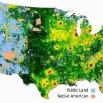
Map idea: Contiguous America's most and least expensive land
9
Map idea: The frequency of red hair across Europe
14
Map idea: The settlements of the New World in 1650
6
Map idea: Largest immigrant nationality in each Westren European country
18
Map idea: Cultural Zones of India [OC]
12
Map idea: Map of the Grand Duchy of Lithuania in 1430.
44
Map idea: The European cities where protests have erupted
8
Map idea: [OC] Distance to the nearest airport with regular flights in India, 2017 vs 2026
14