

Mapcreator is the easiest online mapping tool for you to create customized maps! Anyone can create maps.
Eindhoven, Nederland
Joined March 2009
- Tweets2.1K
- Following1.2K
- Followers1.6K
- Likes8.6K





Pinned Tweet
Breaking news! 🚀 Introducing the new #LocatorMap by #Mapcreator - the quickest solution for your #mapping needs! 🌐 Crafted for speed, simplicity, and responsiveness. Say goodbye to complicated mapmaking! Compatible with all mobile devices - Try it now at locator.mapcreator.io
One point can bring four states or territories together. At Kazungula, four countries come close, but two tripoints are separated by a short Botswana - Zambia border. Swipe through a few boundary oddities! #Quadripoints


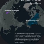
Did you know the native languages of Alaska and Siberia might share a common ancestor? 🌍✨ #language #mapmaking #navajo


Turns out, the roads lead to Rome because there are Romes everywhere. A cartographer’s dream, an Uber driver’s worst nightmare #Rome


Cartography, but make it a Rorschach test! Italy is obviously a boot. The others may require a little more squinting… Which shape convinces you most? #Rorschach


Some countries like Chile are very portrait, while others are much more landscape. How can you frame your country? 🇬🇦 🇨🇱 🇱🇸 #portrait #landscape

In the English language, four seas are named after colors. But where do these names come from? And are there any color-named seas in your language? Let us know in the comments! 🎨 #blacksea #yellowsea #redsea

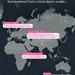
Who can it be now? Just a man in Brussels, a strange lady on a hippie trail and someone lying low in Bombay…
We followed the geography of Down Under and, well… it gets around.
#MenAtWork #LandDownUnder

All aboard! September 1st means the Hogwarts Express is leaving Platform 9¾ once again, some routes require a little magic ✨
Good thing we’ve been teaching Mapcreator a few new tricks… more on that soon 👀
#HarryPotter #AI


Occupational hazard of working at Mapcreator: you start collecting countries…
Team trips, personal holidays, spontaneous adventures and a few stranded destinations later, we’ve covered around 51.5% of the world.
Not bad for a bunch of map geeks!

Every place has its own Alaska! From Nunavut to Western Australia, these regions are where the map gets huge and the dot density gets shy. Which one surprised you most?
#alaska


Mapping the 2026 solar eclipse? We’ve already done some of the tracing for you.
In Ready-to-use maps, you can now find a project with eclipse paths, magnitude curves and key points already mapped in separate layers.
#SolarEclipse2026 #TSE2026

Same population, wildly different polygons. Population density really said, “Let’s make this interesting.” #PopulationDensity


Next time, rather work with us 😎

US government map of Africa mislabels every country at global conference reut.rs/3S1fnwa reut.rs/3S1fnwa

Same rooster, very different soundtrack. 🐓 From cock-a-doodle-doo to kokoriko, kukkokiekuu and cocorico, here’s how the rooster crows around the world. What does it sound like in your language?
Source: reddit & wikipedia


What is someone from your country called in English? There are a lot of suffixes for demonyms, with quite a few odd ones! #worldmap #mapmaking #demonyms


