

she/her • mapping the world one commit at a time. product engineer at esri 🌎 focused on #a11y, usability + design. be kind. ❤️
Minneapolis, MN
Joined April 2009
- Tweets3.8K
- Following610
- Followers1.4K
- Likes4.2K




Kitty Hurley retweeted

Explore new updates in Calcite Design System this October 🎃 to make boo-tiful and consistent experiences in your apps! 👻
esri.social/b8Gi50TWGSI

Kitty Hurley retweeted
🎯ArcGIS Maps SDK for JavaScript now supports reduced motion in 2D maps promoting inclusivity and improving user experiences for more audiences. Explore challenges, techniques, and best practices in our latest blog post 💻
esri.social/wLfy50SxE7y
#a11y
Kitty Hurley retweeted

💥 New ep of #TheBoundingBox
✨ Kitty Hurley @geospatialem joins me today!
🎤 Kitty talks Calcite, Design Systems, #A11y, and the fun on tinkering!
#geodev #webdev
open.spotify.com/episode/4Ny…
Kitty Hurley retweeted

Today is the day! 9a.m. PDT... Join us in less than 2 hours to see the latest advancements in Calcite with the team that builds it!
@EsriDevEvents #javascript #maps

Join us for our upcoming Calcite livestream event! Read more about it here: linkedin.com/events/what-sne…

Kitty Hurley retweeted

📢 Join us Tuesday, October 10th at 9 am PDT for our Calcite livestream 🔴 event! The team will be demoing Calcite's latest components, discussing best practices, and hosting a live Q&A session. Hope to see you there! 👋 #livestream esri.social/hcNl50PUNMh

Calcite 1.0 has arrived! Thrilled to share our exciting new features in the first production release for UI design and front-end development.
Calcite Design System version 1.0 is now available! Create beautiful, user-friendly, and consistent experiences across your apps with minimal effort. Learn more here: esri.social/2Pks50MAzsZ
Happy Developer Day at #esriuc! Lots of sessions highlighting new features and what's to come.

Today is Developer Day at the #EsriUC! I'm excited to see everyone in person and show off some of the amazing things the team has been working on! We'll be doing a tour of our latest tech, and diving into the road ahead - schedule here esri.social/xVFs50JUT4p
@EsriDevEvents


Kitty Hurley retweeted

I don’t know who needs this but…
Working long hours != working hard
Working hard != working well
Inefficiency is a mirage that will make you think great effort is the same as great productivity.
Take care of yourself. When you’re healthy and enjoy your work, results follow.
Congratulations @AliWieckowicz!! 💪

Congrats to Alison Wieckowicz-Goodnature for winning a 2021 #MNGISLIS Polaris Leadership Award!
mngislis.org/page/AlisonWiec…
@MNIT_Services @MnDOT
4

Looking to up your skills in Data management and Programming (SQL, Python, APIs, Azure/AWS, etc.)? We're hiring a GIS Data Steward and App Developer at MN IT Dept. of Natural Resources in the GIS Division! Applications accepted now through Wed Sept. 22.
https://xitter.cf/t.co/8dEBrLxsdr
ICYMI - Two great junior GIS developer positions! #gischat

Kitty Hurley retweeted

Learn from Minnesota's statewide Maps Community of Practice, a group of state staff across 15 agencies. They created a first-of-its-kind set of online resources, guidance documents, tip cards, and web content for making digital maps accessible.
esri.com/about/newsroom/arcn… #a11y

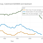
We made a thing! Check out land cover across Minnesota across varying scales, such as catchments and their contributing upstream catchments. (Best access on desktops, but some functionality on mobile/tablets).
arcgis.dnr.state.mn.us/ewr/w…

ALT Harvest area by crop group, catchment 6205800 and upstream highlighting data from 1910 to 2019.
Kitty Hurley retweeted

#programming is not a quick journey 🙅
Don't worry if it feels like you're going slower than you'd hoped. Any progress is better than nothing
Just keep going. We're here for you❤️🥳
#womenintech #womenwhocode #100DaysOfCode #CodeNewbies #javascript #pythonprogramming
