

Formerly run by a small team of professional meteorologists, producing regular convective outlooks for the UK and Ireland from 2008 to 2023.
United Kingdom
Joined June 2010
- Tweets3.2K
- Following55
- Followers8K
- Likes1.3K


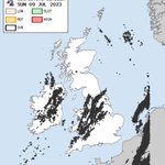
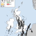
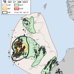

And so that was 2023... here's a look back at the days of thunder recorded during the past year.
South Buckinghamshire was the hotspot with over 20 days of thunder... including today! ⚡️
Thanks for all your comments/interactions during 2023 — wishing you all a Happy New Year 🎆

In the run-up to the New Year we've been taking a look back at the Top 5 most thundery days during 2023...
#1: Tuesday 20th June (34%)
facebook.com/ConvectiveWeath…

In the run-up to the New Year we're taking a look back at the Top 5 most thundery days during 2023...
#2: Sunday 18th June (31%)
facebook.com/ConvectiveWeath…

In the run-up to the New Year we're taking a look back at the Top 5 most thundery days during 2023...
#3: Sunday 9th July (29%)

In the run-up to the New Year we're taking a look back at the Top 5 most thundery days during 2023...
#4: Saturday 8th July (29%)
facebook.com/ConvectiveWeath…

We may have been quiet recently, but we've not forgotten tradition. In the run-up to the New Year we'll take a look back at the Top 5 most thundery days during 2023.
To start us off...
#5: Saturday 17th June (28%)
facebook.com/ConvectiveWeath…

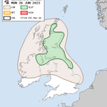
MON 26 JUN 2023:
convectiveweather.co.uk/fore…
The main focus is NE Scotland, but a few odd sporadic strikes may be possible elsewhere from scattered showers

Hail 1.5-2.0cm in diameter in Enniscorthy, Co Wexford on Sunday afternoon 🌩️
xitter.cf/murfogram/status/16729…


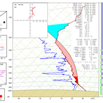
Modified 12z Albemarle sounding gives an insight into the environment awaiting deep convection in NE England.
Sufficient speed shear for supercells if cells remain discrete, backed low-level winds enhancing tornado threat but high cloud bases will limit this risk (initially) 🌩️

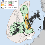
SUN 25 JUN 2023:
convectiveweather.co.uk/fore…
Scattered thunderstorms are likely to develop N + E England and E + NE Scotland, capable of producing large hail (3cm), strong gusts (40-60mph) and perhaps an isolated tornado.
Scattered t-storms also likely in Ireland/Northern Ireland.

SAT 24 JUN 2023:
convectiveweather.co.uk/fore…
Scattered thunderstorms are possible this evening over far NW Ireland and more especially into the Outer Hebrides. Heavy rain with embedded thunderstorms will spread into W/SW Ireland overnight, with the chance of an isolated tornado.

FRI 23 JUN 2023:
convectiveweather.co.uk/fore…
Greatest chance of a few lightning strikes is between Ulster and SW Scotland, but confidence on much lightning occurring is rather low.


A thunder day has been recorded somewhere in UK/Ireland every day since 10th June. So far this month, parts of Ireland have had 7 thunder days.
On Tuesday, 37% of UK/Ireland had a thunder day, the most widespread since 23-24 July 2019
*map may contain distressing shades of red

WED 21 JUN 2023:
convectiveweather.co.uk/fore…
Scattered showers will develop through today, with a few thunderstorms in places - especially NE Scotland. A couple of funnel clouds will also be possible.

Heavy showers have developed along a marked N-S convergence zone Lincs to Northants. 12z Nott. sounding suggests these are stunted by a warm nose in 600-700hPa layer. However, greater instability exists in E Lincs where higher temps/dewpoints reside, yielding >1,000 J/kg MLCAPE.

Convective Weather retweeted

Wow how amazing is this video From valley truckle camelford, looking towards Bodmin video taken from Mike O'Carroll all rights to KWT
@piratefm @BBCCornwall @BBCSpotlight @metoffice @bbcweather @RewindCornwall @IS_RADIOCWALL @NickJF75 @Netweather @ChrisPage90 @weatherbraine
Funnel cloud spotted near Dublin Airport late Tuesday morning 🌪️
xitter.cf/Shauns_Aviation/status…

🌪️A funnell has been spotted over Dublin Airport in the last 20 minutes causing some go-arounds.
An American Airlines has also had to do some Weather avoidance to avoid a heavy raincloud.
📸 Photo via Bartlomiej La/FB
#dublinairport #aviation #tornado #Ireland


TUE 20 JUN 2023:
convectiveweather.co.uk/fore…
Elevated thunderstorms weakening this morning, but the small/📉 chance of severe thunderstorms in eastern England this afternoon.
Elsewhere, scattered showers and thunderstorms in many areas, most widespread in Ireland and NW Scotland.

MON 19 JUN 2023:
convectiveweather.co.uk/fore…
Greatest risk of scattered t-storms during PM/eve across Ireland, possibly marginally-severe hail. A few other showers/isol storms possible Scotland and N. England/N. Midlands.
Overnight, attention turns to Channel Islands & S. England.
