

Commodity Weather Group, LLC (CWG) helps its clients manage and mitigate the weather’s important impacts on agricultural and energy commodities.
Bethesda, MD, USA
Joined March 2014
- Tweets6.4K
- Following68
- Followers9.7K
- Likes551



Record-breaking, super El Niño still on track to peak in Nov-Dec, but maintain its super-status through winter months.

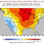
End of 11-15 day is inside the first week of November, and all-ensemble mean/clusters in good agreement on continued strong Pacific jet influence for warm Lower 48 pattern.

Models lose U.S. heating demand over past 24 hours with warmer changes for East, South, and Midwest.

Should see lot of this this winter thanks to super El Niño: very strong Pacific jet stream influence on U.S. pattern.

11-15 day 2-meter temperature departures ensemble clustering: more warmer than not options yet again.

Models agree on warm-prevailing national pattern for late Oct into early Nov, but AI models are warmer on East Coast than traditional NWP guidance.

Odds are high for the developing wet pattern in Paraguay soy to persist this season based on strong El Niño analogs, although similar cases did not encounter yield risks. commoditywx.com/news/2026101…

Teleconnection shifts in the 11-15 day need a little more help to support critical rains for France wheat. commoditywx.com/news/2026101…

Persistently-positive ABNA, WPO, and especially GLAAM, thanks to Super-Niño, continues to fuel very warm Q4 narrative for Lower 48.

October is on track for 3rd warmest on record for U.S. heating demand. This is only month that pre-2000s year holds top spot for warmest: 1963.


Possible MJO influences in late October generally support continued wetter route than much of the modeling for N. Brazil and Argentina. commoditywx.com/news/2026101…

Models lost U.S. HDD demand over weekend as combination of super El Niño and strong negative Pacific Decadal Oscillation (PDO) continues warm to very warm autumn narrative. Oct on track for 3rd warmest HDDs and 1st hottest CDDs.


DC surges into 80s over net two days before diving into 50s for highs and 40s for lows this weekend.

Incredibly strong positive global atmospheric angular momentum blowing away daily record peaks from 1997 and 2015. This Super El Niño is superior and dominating the global atmosphere.

WeatherNext guidance causing some Mid-Atlantic mischief for upcoming bal-week with hotter 80s potential mid-to-late, when traditional models are cooler. Difference seems tied to Hurricane Simon interaction with Southwestern trough that is enhanced by Rachel this weekend.


