

Award winning journalist and meteorologist that can be heard across West Virginia on the MetroNews Radio Network and in Charleston on https://xitter.cf/t.co/9opErCauQc.
Charleston, WV
Joined May 2009
- Tweets33.2K
- Following576
- Followers3.1K
- Likes4.3K




A Frost Advisory has been issued for Wayne, Cabell & Others in WV, OH, KY and VA from 1 AM to 9 AM EDT Monday. Temps near 35F may form frost, which can damage sensitive plants—cover them or bring indoors.

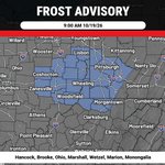
A Frost Advisory has been issued for Hancock, Brooke, Ohio, Marshall, Wetzel, Marion & Monongalia in WV and OH until 9:00 AM EDT 10/19/26. Temps as low as 35F may form frost 1–9 AM; cover sensitive plants to prevent damage.

Freeze Warning issued for Hampshire, Morgan, Berkeley & Others in MD, VA, and WV until 8:00 AM EDT Sun. Sub-freezing temps in the upper 20s to low 30s possible from 1–8 AM; frost/freezes could kill crops and damage unprotected outdoor plumbing.


Freeze Warning issued for Mercer, Summers, Monroe & Greenbrier in NW NC, SW VA, and SE WV from 1 AM to 9 AM EDT Sun. Sub-freezing temps as low as 31F may cause frost/freezes that can kill crops and damage unprotected outdoor plumbing.

A Freeze Warning has been issued for Hancock, Brooke, Ohio & Others in east-central OH, western PA, and northern WV from 1 AM to 9 AM EDT Sunday. Sub-freezing temps in the upper 20s to around 30 may cause frost/freezes that can kill crops and sensitive vegetation.

Freeze Warning issued for Wayne, Cabell & Mason, and others in NE KY, SE OH, SW VA and WV through 9 AM EDT Sunday. Sub-freezing temps as low as 29 F from 1–9 AM; frost/freeze could kill crops and damage unprotected outdoor plumbing.

Freeze Watch for Wood, Pleasants, Tyler & Others from 1 AM EDT Sunday through 9 AM EDT Sunday. Sub-freezing temperatures as low as 30 possible.


SPC Day 1: Slight Risk covers parts of West Virginia today. Scattered severe storms are possible. Marginal Risk: tornado less than 2%, damaging wind 5%.

Severe Thunderstorm Warning has been issued for Barbour, Lewis, Randolph, and Upshur counties in northeastern West Virginia and is in effect from 2:59 PM through 3:30 PM EDT. Radar-indicated storms near Buckhannon may bring 60 mph wind gusts and hail up to 0.75 inches.

A Freeze Watch has been issued for Mercer, Summers, Monroe, and Greenbrier in NW NC, SW VA, and SE WV, from late Sat night through Sun morning, expiring 9:00 AM 10/18/26. Temps may drop to 29; frost/freezes could kill crops and sensitive vegetation.

Severe Thunderstorm Watch 686 is in effect until 8:00 PM EDT for the District of Columbia; Maryland; New York; Pennsylvania; Virginia; and West Virginia. Conditions are favorable for severe storms with damaging winds, large hail, and frequent lightning.

A Freeze Watch has been issued for Hampshire, Morgan, Berkeley & Others in MD/WV/VA from late Sat night through Sun morning, expiring 8:00 AM 10/18/26. Sub-freezing temps in the upper 20s to low 30s could kill crops and damage unprotected outdoor plumbing.

SPC Day 1: Slight Risk covers eastern West Virginia today. Scattered severe storms are possible. Slight: tornado less than 2% and damaging wind up to 15%. Marginal: tornado less than 2% and damaging wind up to 5%.

Freeze Watch for Hancock, Brooke, Ohio & Others from 1 AM EDT Sunday through 9 AM EDT Sunday. Sub-freezing temperatures as low as 30 possible.

SPC Day 1: Slight Risk covers eastern West Virginia today. Scattered severe storms are possible. Slight: tornado less than 2%, damaging wind up to 15%. Marginal: tornado less than 2%, damaging wind up to 5%.

SPC Day 1: Slight Risk covers eastern West Virginia today. Scattered severe storms are possible. Slight: tornado less than 2% and damaging wind 15%. Marginal: tornado less than 2% and damaging wind up to 5%.

SPC Day 2: Slight Risk covers eastern West Virginia tomorrow. Scattered severe storms are possible. Slight: tornado less than 2%, damaging wind up to 15%. Marginal: tornado less than 2%, damaging wind up to 5%.

