

Surface and subsurface water from space, Group leader "Remote sensing and natural resources modelling" @Luxembourg_RTO
Joined February 2009
- Tweets129
- Following482
- Followers142
- Likes533







Patrick Matgen retweeted

📣 Eager to delve into #AI technologies for processing multi-source #EarthObservation data?
Don't wait any longer & apply before 10 May for our 3-day summer school on this topic 👉 list.lu/en/event/summer-scho…
📅 From 10 to 12 June
📍 Luxembourg City, Youth Hostel
Patrick Matgen retweeted
[#LEODAY2024] 🛰🌍The agenda of the Luxembourg Earth Observation Day is online!
Check it out now and register for this event on 13 June 2024 👉list.lu/en/event/luxembourg-…
Eager to be part of our #LEODAY2024? Check our sponsoring packages & showcase your brand at this event.
Patrick Matgen retweeted

We're glad to have hosted @RssHydro & @LIST_RemoteMod at chars of northern 🇧🇩 where we work with some of the most vulnerable communities.
We look forward to the findings which shall help to #SaveLives & in #ClimateAdaptation.
#LIST #Flood #FloodAction #Research #Collaboration

Another river, another mission.
In partnership with @LIST_RemoteMod & @friendship_ngo, we are exploring how to help the most vulnerable communities in 🇧🇩. The project is supported by @cooperation_lu & @FnrLux. Thanks to all partners for the meaningful cooperation.


Day2 of the @LIST_RemoteMod & @RssHydro exploratory study in 🇧🇩 supported by @cooperation_lu & @FnrLux. Thanks to @friendship_ngo for allowing us to meet several communities affected by floods and to better understand how our research can support their disaster resilience

Patrick Matgen retweeted

We are organizing a summer school on #AI and #EO on 23-24 March this year. To participate, apply before March 15th: ai4copernicus.org/summer-sch…. We also invite you to attend the third edition of the #AI4Copernicus conference in #Mondorf on the 25th of March.
Patrick Matgen retweeted
Come work with us: we have five positions open in our group! #jobalert #EOjobs #ResearchLuxembourg #postdocjobs #vacancy
Space data to help Pakistan recover from its record floods - Sentinel Success Stories - Sentinel Online sentinels.copernicus.eu/web/…
A delight to see Concetta Di Mauro successfully defend her PhD thesis @tuvienna. It was a pleasure and honour to have you @LIST_RemoteMod ! Thanks to @FnrLux for funding her research on assimilation filters enabling long-lasting flood forecast improvements using satellite data

Huge congratulations to @Jie_Zhao_RS for her PhD defence at @geodepartment ! It has been an honour to be one of your supervisors. Some of her contributions to flood mapping using SAR data can be found here: ieeexplore.ieee.org/document…
sciencedirect.com/science/ar…
sciencedirect.com/science/ar…

Today and tomorrow, I am representing @LIST_Luxembourg at the Luxembourg booth J11 of #IAC2022. Looking forward to presenting our research and technologies supporting #environmentalmanagement, #disastermanagement, #precisionagriculture and #maritimesurveillance.

Patrick Matgen retweeted
Our group is offering a permanent position for a scientist in #flood modelling and #satellite EO #data #assimilation. Please spread the news to potential candidates! The application link is below, thanks!
app.skeeled.com/offer/61f16d…
Very glad to be part of this great team.The GFM of @CopernicusEMS is indeed the result of years of scientific developments, most recently within @eshape_eu.
Special thanks to @FnrLux, @EU_Commission and @ESA_EO for supporting our research for many years!
europa.eu/!XHpxjf
WASDI, A SPIN-OFF TO BE FOLLOWED CLOSELY! list.lu/en/news/wasdi-a-spin… via @LIST_Luxembourg
Patrick Matgen retweeted

Check out the article about WASDI, the joint-venture #startup from @LIST_Luxembourg, @RssHydro & FadeOut Software. WASDI stands for Web Advanced Space Developer Interface and it's an online #EO Image Elaboration Software to process EO images in the #cloud & develop your #apps
This quoted post is unavailable.
Patrick Matgen retweeted
@Jie_Zhao_RS was recently interviewed for @FnrLux’s “Spotlight on Young Researchers” campaign, and talked about her work on a fully automatic SAR-based flood mapping algorithm. Have a look at her interview here: tinyurl.com/yd4zdm6m
Patrick Matgen retweeted

#eurogeo workshop is starting in a while!
Join us tomorrow, Tuesday 21st of September and know more about @eshape_eu services!
More at bit.ly/3lHtF0U

Patrick Matgen retweeted
On 14 and 15 September we will take part in the space forum @ICTSpring. Our colleague Marco Chini is a keynote speaker and we will have a booth with @LIST_Luxembourg, so come see us there!

🌌 Marco Chini, @LIST_Luxembourg will take part in #SpaceForum, talking about "LSA Data Centre & the Wasdi #CloudComputing platform: a synergy to facilitate the #Exploration of satellite EO #Data for #UrbanApplications"
REGISTER HERE 👉 buff.ly/2Y2aoeK
#ICTSpring2021

Patrick Matgen retweeted

There's a rush to develop tech to predict, monitor & mitigate #climatechange
🛰 HASARD generates real-time flood maps
🇱🇺 A made-in-Luxembourg sol. used by @EU_Commission @esa @CopernicusECMWF @NASA @UN
ℹ @LIST_Luxembourg @FadeoutSoftware @RssHydro
researchluxembourg.lu/2021/0…
Patrick Matgen retweeted

Our Rapid Mapping service is activated for the #floods in #Luxembourg. The @DisastersChart was triggered and @UNOSAT has been designated as project manager.
More to come 👉
ow.ly/LvG550Fxr4D
@CGDISlux @LIST_Luxembourg

Patrick Matgen retweeted
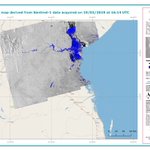
Today's image shows that the Luxembourg #floods around Mersch and Bettembourg have moved downstream, and that the flood extent has decreased in these areas:

ALT Satellite image showing the flood extent around Mersch and Bettembourg on the morning of July 16th, 2021