

Meteorologist @ WTOC
Savannah, GA
Joined January 2016
- Tweets7.3K
- Following107
- Followers2.3K
- Likes162
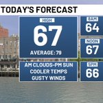




Happy Saturday! Morning clouds give way to afternoon sun. Gusty winds over 30mph bring in much cooler air.


The NWS has released the data on Saturday's tornado in eastern Bulloch county. Tornado started around 2:12pm near Clito and Rough Rider Road. It stayed on the ground for about 1 mile before dissipating near Beatty Downs Drive at 2:13pm.


Thunderstorm over coastal McIntosh county is moving quickly to the north. Locally heavy rain likely.

Tornado Watch has been trimmed back to include Effingham, Screven, Jasper, Beaufort and Hampton counties until 8pm.

We had 2 confirmed tornadoes today in Screven county. The first around 2:35pm near Halcyondale. The second was around 3:15pm just northwest of Newington.


Watching some rotation moving across northern Beaufort county. Looks like cell is moving to the NW towards Chisolm.


Keeping our eyes on some rotation near West Green. Storm is moving NE about 55mph into Jeff Davis County.

Our main concern for the rest of today is the potential for an isolated tornado. Rain will be on and off but potentially heavy at times. Conditions may change fast so have a way to receive wx alerts.

Isaias better organized and is forecast to become our first hurricane of the season Thursday. Landfall Friday PM along the AL/FL border. Although the center stays well to our west we will still feel some impacts. Rain may be heavy at times with a low end tornado threat Saturday.

No changes to Tropical Depression 9 at the 11pm advisory. Still expected to be our first hurricane of the season Thursday and make landfall Friday night along the central Gulf coast.

Tropical Depression 9 has formed in the southern Gulf. The storm is forecast to become a hurricane Thursday and make a landfall late Friday night along the central Gulf coast. This will bring us a wet weekend.

