

Christian | Weather Enthusiast | Dev/Founder - GFC | Dev Lead & Operations - @weathertrackus | TAHS - '25 | OU - '29 | Opinions my own
Joined July 2020
- Tweets5.7K
- Following2.6K
- Followers537
- Likes6.1K






Super retweeted

We want to take a moment today to honor, thank, and celebrate all of our Veterans on this Veterans Day!
From all of us here at WTUS, Thank You for the sacrifice you made for us all in this great country. We are eternally grateful.
If you know a Veteran, be sure to thank them…

Super retweeted
As we move onto November 3rd, 2026 we just want to remind everyone to make sure that you check your voter registration and get out and vote!
Some storms may make it a little tricky today so make sure you check your local conditions and remain weather aware but don't let it stop you from making your voice heard today.
We at WTUS highly encourage you to get out and vote however you vote! We have some resources linked below to help you out today ↓
Super retweeted
Tune in as we break down the latest on the severe weather threat today across the Southern Plains. xitter.cf/i/broadcasts/2onAQBBOr…

Super retweeted
The SPC has expanded the Enhanced Risk (10% tornado risk) to include the OKC metro & Norman, OK.
The potential for a few tornadoes (including a couple of strong tornadoes) appears to be increasing for Central OK this evening.

Super retweeted
Yet another incredible Aguacero update, featuring a massive overhaul to meteograms, new parameters/variables, and so much more for Free & Paid Tiers!
Start your 7-day free trial, and get 20% off your first month or year using code on any tier: WTUS20 !


🚨Aguacero 6.12 is live
📈 Rebuilt meteograms with full ensemble member grids
🎲 Build your own ensemble probability variables
🌀 Ensemble high and low tracks
🆓 ECMWF, GDPS, NBM and RGEM now on the Free plan
❄️✈️ New NBM winter and aviation fields
🇯🇵 AMeDAS weather stations
📡 Bring your own radar feeds
💾 More saved bundles
🖥️ aguacerowx.com/app
📘 Meteograms guide: aguacerowx.com/guide/meteogr…
📘 Ensembles guide: aguacerowx.com/guide/ensembl…
Super retweeted
Thanks again to everyone who tuned into our live broadcast tonight! We made a lot of changes, some benefited us tonight, some added some difficulty. But we hope that no matter what you got the latest information that you needed tonight.
We will keep refining our craft, and tightening the edges to make the experience better for all of you. Until then we'll continue our updates here on Twitter/X and we hope to see you tune in on our next broadcast, and obviously stay weather aware!
Super retweeted
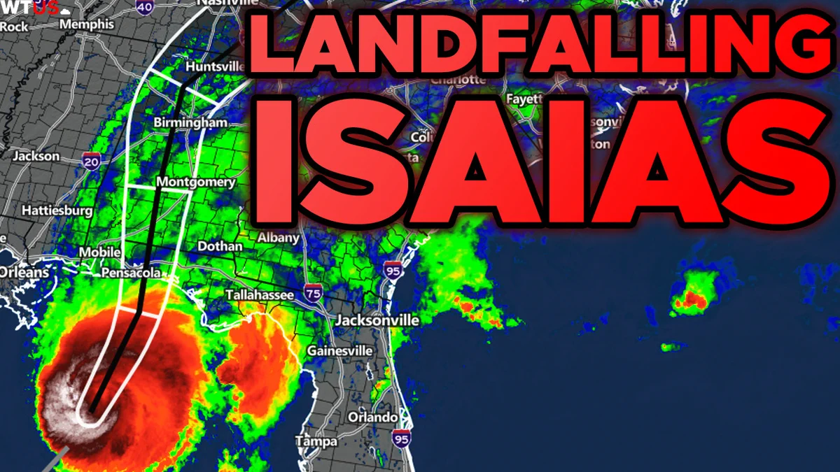
We're live tracking Isaias as it barrels down on the Gulf Coast. Stay tuned for live coverage starting this evening! xitter.cf/i/broadcasts/1nxnRBlBB…
Super retweeted
Tropical Storm #Isaias Advisory 4:
Isaias is getting better organized this morning, and may begin a bout of intensification later today as organization continues.
NHC still forecasts Isaias becoming a strong Category 2 (110mph) Hurricane in the Northern Gulf on Friday. Some slight weakening is possible right before landfall late Friday or early Saturday, but a high-impact event is expected for the Central Gulf Coast this weekend.
Storm surge, damaging winds, heavy rainfall, and tornadoes will occur along the Gulf Coast, especially on the eastern side of the system.
If you haven't begun preparations at this time, do so TODAY! While Isaias is still about 2 to 2.5 days away from landfall, preparing sooner, rather than later is best.


Super retweeted
Unlike Michigan, we're not paying the heat dome to stick around and win...
It's going to continue to be hot for the next 5-7 days across the Central & Southern U.S...


Super retweeted
Unfortunately, another heatwave will impact parts of the Central Plains and Eastern U.S. next week.
Details here:
youtube.com/watch?v=3xkIfbms…

Super retweeted
Revolutionary update from Aguacero, featuring archival data that NO OTHER consumer program offers!
Here are a couple examples featuring the January 10, 2025 Winter Storm and the April 2, 2025 tornado outbreak. There is MUCH more data to explore as well!
🚨Aguacero 6.0 is live — and it's revolutionary
Relive your favorite events with Archive Mode:
ERA5 (1940+)
NEXRAD L2 (1991)/L3 (1999) with 3D
ASOS (1900)
LSRs, NWS alerts, RAOB, ACARS & VWPs
Switch Live → Archive
FREE for all users (with limits)
aguacerowx.com/app


Super retweeted
More Unsettled Weather Expected Across Parts of the Country & More!:
youtube.com/watch?v=HybTVcTW…
Super retweeted
Aguacero continues to be the leader with the most advanced and customizable weather software available for everyone!
Check out some of the latest features in the most recent 5.12 update:
• 3D Satellite
• Frame Blending
• Min/Max values for products
• METARS/AWOS/RAWS Station Plots
...and many (and we mean many) more features overall!


🚨Aguacero 5.12 is Live! Our biggest tropical update yet.
🌀 TC Hub
✈️ Recon & dropsondes
🛰️ 3D satellite (Pro)
📺 Frame Blending (Pro)
📡 RAWS + JTWC data
⚡️ GLM Energy Filter
🌪️ TVS/Nadocast Update
🎒 Alert/Marker Bundles
And so much more! aguacerowx.com/app

Super retweeted
Potentially dangerous flash flooding event currently beginning in the northeast, with some areas already seeing spots of 4-6 inches of rain fallen and multiple Flash Flood Warnings currently in effect.
The WPC has placed a MODERATE Risk of flash flooding from Philadelphia to southern Vermont, where dangerous and life-threatening flash flooding is most likely to occur.
Within the next 48 hours, rain totals in some areas could reach up to 5, potentially nearing 10 inches, resulting in dangerous flash flooding concerns.
If you are put under a Flash Flood Warning, seek higher ground immediately! And remember, when approaching flooded roads, turn around, don't drown!
A Flood Watch remains in effect for these areas until 8:00PM EDT tomorrow.


Super retweeted
Good Morning! Welcome to the WTUS Daily Briefing, a new post project from the team. We'll give you an overview of what's happening today before you get out too far into your day.
Topics:
- The South is being the South
- More rain/ slight flooding risk
- No major severe weather expected today
- Hurricane season continues to have a slow start
- A note from the poster
Let's get into it! 🧵

Super retweeted
The tunnel under the Norfolk Southern Harrisburg Line at Hanover Street in Hummelstown, Pennsylvania is destroyed due to flood waters.
Significant flash flooding continues across the region.
Video from: @MilkC4ke321
Super retweeted
HAPPY 250th, AMERICA!
Hopefully everyone has a great 4th of July, and if you're celebrating America's 250th outdoors, be mindful of severe heat, and severe weather today.
There are two Enhanced Risks, both of them wind-driven, surrounded by broader Slight/Marginal Risks across parts of the Plains, Midwest and Mid-Atlantic.
Outside of that, general, common summertime isolated to widely scattered Thunderstorms are possible across much of the country east of the Rockies.
If you're in a severe risk today, remain weather aware! Storms will be mostly capable of producing damaging winds, with a large hail risk, mainly across the Central Plains. A tornado or two will be possible in parts of Kansas and Oklahoma this evening.
Regarding the heat, this significant heatwave continues across the South, Midwest and East Coast. Although not has bad for many areas as it was earlier this week, dangerous heat indices will likely exist this afternoon, with in the 90s and 100s. Actual air temperatures won't be that much lower either.
Please stay hydrated and take frequent shade/indoor breaks when possible. If symptoms of heat exhaustion or stroke appear in you or someone else, seek help immediately!
Stay safe, and have a great celebration of freedom!
#USA250

