

Future and current broadcast meteorologists from the @UFJSchool @UF.
UF College of Journalism
Joined May 2011
- Tweets21.1K
- Following216
- Followers9.8K
- Likes1.3K

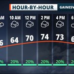





Tomorrow some showers and sprinkles but tomorrow we will see 70s! And then later in the week we will see 80s! #UFWeather #FLWX

Tomorrow some showers and sprinkles but tomorrow we will see 70s! And then later in the week we will see 80s! #UFWeather #FLWX

After cold... We had freezing temperatures this weekend, we are going to see a fast turn around with warmer temperatures all week. #UFWeather #FLWX

Another blast of cold air is set to move in for the weekend. Both Saturday and Sunday morning will be near the freezing mark. #UFWeather #FLWX

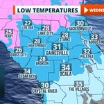
North Central Florida will experience some of the coolest temperatures of the month Wednesday morning.

Getting the last of the rain outside of the Ben Hill Griffin Stadium. Nearly 1.5 inches of rain have been recorded in the past 24 hours.


Line of strong storms moving toward North Central Florida. Expect strong winds to continue ahead of the line throughout the afternoon and into the evening.

UF Weather retweeted

A Heat Advisory has been issued for the entire Florida peninsula today, where heat indices are expected to near 110°. Stay safe while celebrating our nation's independence: Limit time outdoors, seek shady spots, and stay hydrated. #FLwx

A Heat Advisory is posted for today as feels-like temps over 100⁰ are likely. Isolated afternoon and early evening storms are possible, but skies should be clearing for those skyrockets at Fanfares & Fireworks 2023!


It has been a wet month so far. While we may not be close to record territory yet, it won't take much to land in the top 10 rainiest Junes on record in #GNV. All it will take is an additional 4" of rain between now and June 30th. #UFwx #Rainesville #FLwx

Rainfall totals following this morning's widespread strong storms is between 3 and 6 inches in much of #Alachua, #Gilchrist, #Levy, and #Marion Counties. @JustinBallardWx says additional storms this afternoon could result in a heightened flood threat. #UFwx
This Post is from an account that no longer exists. Learn more
A Severe Thunderstorm Watch is in effect in for our area until 2 PM. Storms will be capable of producing damaging winds and large hail. Storms will also be capable of producing heavy rain and frequent lightning. Stay #WeatherAware through this afternoon. #UFwx #FLwx

Severe Thunderstorm Watch for Alachua, Baker, Bradford, Clay, Columbia, Duval, Flagler, Gilchrist, Hamilton, Nassau, Putnam, St. Johns, Suwannee and Union County until 2:00pm EDT. Details on the Florida Storms app. #flwx

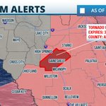
Tornado Warning for Alachua County has expired but this dangerous storm has a history of strong rotation & funnel clouds. Large hail & damaging winds are still possible as the supercell tracks thru Gainesville & areas to the south. Storm is still spinning so stay alert!

