




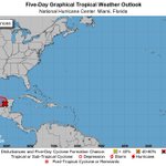


Hey so #Cristobal forecast cones are starting to include parts of the US Gulf coast. Just want to remind everyone that this can and will change. This storm may also be rather sizable and this only shows the dead center. Long story short, all of the Gulf should keep an 👁 on this


Tyler Smith retweeted

This will likely become Cristobal in the coming days.

Tropical Depression Three: Sunrise to sunset #HurricaneSeason #Cristobal #TXwx #LAwx #MSwx #ALwx #FLwx
Tropical Depression Three: Sunrise to sunset #HurricaneSeason #Cristobal #TXwx #LAwx #MSwx #ALwx #FLwx
Tyler Smith retweeted

WOW! 😳That’s a good sized large dust devil! Tagging @NWSCharlestonSC for thoughts. Rebecca Hankins Martin caught it around 2pm on Saturday in Screven County! @StormHour @DustStormNews @WTOCFirstAlert @WTOC11
(For fun) Will the 2020 Atlantic Hurricane Season have to dip into the Greek alphabet for names? #wxTwitter
71%Yes
29%No
21 votes • Final resultsTropical cyclone formation likely immenent in the Gulf. No immediate threat to US mainland, but impacts *could* eventually come. Nothing to worry about, just something to be aware of #TXwx #LAwx #MSwx #ALwx #FLwx #Cristobal #Invest93L

KIWA is putting on a show this evening. @NWSPhoenix is reporting hardware malfunction #AZwx
Will Invest 92L develop into something? Official #NHC odds currently at 50%, could be the 3rd preseason #Atlantic storm of 2020 (which would be unprecedented I believe) nhc.noaa.gov/gtwo.php?basin… #Invest92L #Cristobal #HurricaneSeason #wxTwitter
26%Yes, a depression
53%Yes, a named storm
5%Nope
16%No, eyes on Gulf, though
19 votes • Final resultsSure enough, the #Minneapolis fire is visible on radar. Go check out KMPX #MNwx #MinneapolisProtests


