

Operational forecaster in the private sector | Millersville University alum | Tweets consist of cyclones, ⚜ Saints, and other spinning clouds.
Joined August 2013
- Tweets7.2K
- Following1K
- Followers3.6K
- Likes65.4K






Pinned Tweet
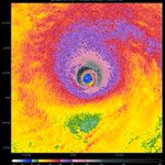
This has to be one of the most incredible and terrifying satellite loops that I've seen in a while. You can see 5 violent mesovorts spinning around the eye of #Melissa this morning.
Steve Copertino retweeted

I've been a big fan of the HREF, so I don't want to see it axed, but it seems like this is going to happen no matter what any of us operational people think.

Steve Copertino retweeted

🌀Hurricane Isaias Damage Analysis (1/4)
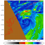
NWS Mobile continues to investigate an extreme corridor of damaging winds WEST of Isaias' center. This radar/velocity loop shows intense winds, with deeper blues/greens indicating higher wind speeds, possibly associated with a "sting jet"
Steve Copertino retweeted

REFS verification for cities like Miami, Florida and Chicago, Illinois remains quite concerning.
HREF members and NWS forecasts are beating it handedly.


Steve Copertino retweeted

Very glad our work on WeatherNext Cyclones (WN-C) at @GoogleDeepMind and @GoogleResearch proved useful for forecasting Hurricane Isaias. We were also pleased to see WN-C’s 1,000 member ensemble being used by meteorologists to help assess the full range of possibilities for Isaias’s track and intensity. Such large ensembles are one of the benefits of ML weather models, which are more efficient than traditional physics models.
There was debate among meteorologists whether wind shear and dry air would prevent Isaias from rapidly intensifying. WN-C predicted a more easterly path away from these weakening factors, with a >50% chance of a major hurricane from Oct 6th onwards, which steadily grew in confidence until Isaias eventually did reach Category 3 status three days later on Oct 9th, shortly before landfall.
Our paper on the front cover of @Nature last month evaluated WN-C against the leading physics models across more than 200 tropical cyclones globally from 2023-2025. We found that WN-C achieves ~1 day of additional useful lead time for cyclone track and intensity (an advance that typically took a decade to achieve). Getting both track and intensity right proved crucial for predicting the true threat of Isaias, and though this was just N=1 tropical cyclone, it’s great to see our breakthrough helping to protect lives and livelihoods in an operational setting.
Read the paper here: nature.com/articles/s41586-0…


Last week, Hurricane Isaias made landfall in the Florida Panhandle. Our thoughts are with everyone affected and with the recovery efforts still underway. Earlier and more accurate forecasting can help protect communities by giving them more time to prepare, and we are grateful that Google’s WeatherNext model was able to assist the @NWSNHC 's expert forecasters.
Based on initial evaluations, here's how our model supported the response to #Isaias:
- Tracking the Hurricane’s Path: WeatherNext was the most accurate model on the storm’s track. While traditional physics models predicted landfall closer to New Orleans, WeatherNext correctly predicted a path further east. This allowed NHC forecasters to highlight the potential for wind and storm surge impacts in the Florida Panhandle from their very first forecast.
- More Time to Prepare: Up to three days before landfall, our model consistently predicted its eventual location in the Florida Panhandle to within 60 km or less, supporting the NHC as they honed in on a track toward the Florida Panhandle and issued hurricane watches and warnings to give officials in Florida, Alabama, and Mississippi more time to prepare.
- Early Indications about Intensity: Early on, WeatherNext accurately predicted the intensification to a major hurricane. Alongside the regional hurricane models HWRF and HMON, WeatherNext’s intensity forecasts helped NHC forecasters to predict that the Isaias would approach the coast as a category 2 hurricane from the very first advisory.
Giving communities more time and more accurate warnings is critical for protecting lives and livelihoods. While model performance varies from storm to storm, Isaias reflects our broader findings. In our recent @Nature paper co-authored with NHC forecasters, evaluating 200+ global tropical cyclones, we found our model provides ~1 day of additional lead time for both track and intensity.
It’s been an honor for the @GoogleDeepMind and @GoogleResearch teams to work alongside NHC forecasters. By combining AI, physics models, satellite data, and the crucial expertise of meteorologists, we're excited to keep pushing the boundaries of forecasting to help protect communities.
Incredible job by @BevinsWx breaking down the interesting corridor of damaging winds NW of the center of #Isaias last week! Very curious what the NHC tropical cyclone report has to say about it, and I'm sure we'll see at least a few research papers in the coming years!


THEORY THREAD | What happened in Pensacola, Florida during Hurricane #Isaias.
The strongest winds in a tropical cyclone is typically seen in the NE Quadrant of the cyclone. However, Isaias strongest winds near landfall occurred in the NW & SW quadrants. So what happened?

Steve Copertino retweeted

🆕: Europe’s 1st geostationary sounder enters service today! 🛰️
The satellite - renamed as 'Meteosat-13' - will detect signs of atmospheric instability even before clouds form, helping forecasters see weather risks earlier.
Learn more: bit.ly/4zshitH
Steve Copertino retweeted

Our 12Z experimental HAFS forecast the day of landfall picked up on the structure pretty well, just showed it a little further offshore. It's not really a traditional "sting jet" at the base of the "comma head" because there wasn't one yet (hadn't really fully ET'd yet). But if you look, it seems like there was some really robust subsidence on the backside that likely brought strong winds down to the surface, similar to sting jet. Very interesting case that I want to dig into more.


Steve Copertino retweeted

🚨Aguacero 6.10 is live
🇪🇺 148 European radars + MeteoAlarm & 🇨🇦 ECCC alerts
📈 Model time-height plots
🌀 Model cross sections on the map
🌊Armor3D SSTs
⚙️Customize performance/RAM/threads
🪟 Dock, drag & resize charts
Placefile support
🌍 5 languages
aguacerowx.com

Steve Copertino retweeted

Terrifying footage of a violent tornado ripping through the city of Marsala in Sicily, Italy earlier this morning. Heavy damage reported in the area.
Steve Copertino retweeted
The last 3 runs of HAFS-B seem to be trending towards a slower extra tropical transition for #Isaias today, with the core potentially remaining intact closer to the coast. This won't change the overall impacts that much, but it could mean a core of stronger winds and surge near the landfall region.
I remember we had a similar trend happen in Milton, where HAFS was originally a little too quick to obliterate the core and we ended up with a Category 3 landfall instead. Isaias is not nearly as strong as Milton at peak, but still this will be something to monitor.
Recon has found flight level winds of around 120 knots, which should make #Isaías a major hurricane with winds around 120 mph. The combination of extreme upper level divergence and very warm SSTs have been able to hold off strong westerly shear for now.
Steve Copertino retweeted
For folks in Tallahassee and the surrounding area, I would pay close attention to the severe threat and make sure you have a way to get warnings overnight Friday even if you're asleep. I don't think we'll get widespread power outages like some of the storms there recently. But the tornado threat is real and could be pretty bad if one ends up in the wrong spot.


Little concerned about how compact #TD9 looks this evening. This will probably have 36-48 hours before westerly shear really starts to pick up, so a small core could ramp up quickly with 30-31 C waters.
Would be nice to have recon, but we'll see how this looks in the AM.
The intensity of #92L on the 18z GFS is likely overdone, but that's one heck of a jet interaction. We'd likely see this start to take on more extratropical characteristics near landfall, though that would extend impacts well beyond the center of the storm.


Steve Copertino retweeted

Every NEXRAD radar in the Florida panhandle area is offline today, making the current heavy rainfall to the area essentially undocumented.
This map show the radar quality index. The less quality, the less rain you'll see on radar, the less likely important storm structure information (for warnings) will be there. Radar-estimated precipitation totals will be WAY off.

Grain of salt here...but a recent SAR pass showed winds around 138 knots in the NW quad of #Nolo this afternoon.
Regardless, it's been very cool to see Nolo almost undergo an extratropical transition and then intensify all the way back to a major hurricane in such a short time.


