

Scalia Laboratory for Atmospheric Analysis is a meteorological forecasting and research facility on Ohio University's campus. Wx Hotline: 740-593-1717 #ohiouwx
- Tweets5.4K
- Following394
- Followers1.2K
- Likes693


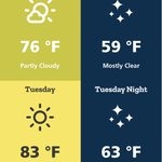
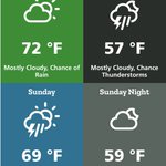


ALT A Frost Advisory has been issued for portions of southeastern Ohio and central, northern, and western West Virginia between 2 AM and 9 AM EDT Tuesday, October 20th. Temperatures as low as 33 degrees will result in the formation of frost.

ALT This graphic displays a flash flood warning plotted on a map. The warning is in effect until 8:30 PM EDT. The warning includes Nelsonville OH, Glouster OH and McConnelsville OH. This warning is for Northwestern Athens County in southeastern Ohio, Morgan County in southeastern Ohio, Southeastern Perry County in southeastern Ohio and Northwestern Washington County in southeastern Ohio. Avoid walking or driving through flood waters! Move immediately to higher ground! There are 20,394 people in the warning along with 12 schools and 1 hospital.

ALT This graphic displays a flash flood warning plotted on a map. The warning is in effect until 7:30 PM EDT. The warning includes Nelsonville OH, Glouster OH and McConnelsville OH. This warning is for Northwestern Athens County in southeastern Ohio, Morgan County in southeastern Ohio, Southeastern Perry County in southeastern Ohio and Northwestern Washington County in southeastern Ohio. Avoid walking or driving through flood waters! Move immediately to higher ground! There are 20,394 people in the warning along with 12 schools and 1 hospital.

ALT This graphic displays a special weather statement plotted on a map. The statement is in effect until 10:15 AM EDT. The statement includes Athens OH, Nelsonville OH and New Lexington OH. STRONG THUNDERSTORMS WILL IMPACT MEIGS, PERRY, SOUTHWESTERN WASHINGTON, MORGAN, SOUTHEASTERN VINTON, ATHENS, NORTH CENTRAL MASON and NORTH CENTRAL JACKSON AND WEST CENTRAL WOOD COUNTIES THROUGH 1015 AM EDT. The threats associated with this storm are wind gusts up to 40 MPH and no hail is expected. Seek shelter in a sturdy structure until the storm passes.

ALT This graphic displays a severe thunderstorm warning plotted on a map. The warning is in effect until 11:45 PM EDT. The warning includes Athens OH, Albany OH and Rutland OH. This warning is for Northwestern Meigs County in southeastern Ohio, Northeastern Gallia County in southeastern Ohio, Northeastern Jackson County in southeastern Ohio, Eastern Vinton County in southeastern Ohio and Southwestern Athens County in southeastern Ohio. The threats associated with this warning are wind gusts up to 60 MPH and pea sized hail. There are 46,375 people in the warning along with 11 schools and 2 hospitals.

ALT This graphic displays a tornado warning plotted on a map. The warning is in effect until 11:30 PM EDT. The warning includes Zaleski OH. This warning is for East central Vinton County in southeastern Ohio and West central Athens County in southeastern Ohio. The threats associated with this warning are a radar indicated tornado and pea sized hail. There are 992 people in the warning along with 0 schools and 0 hospitals.

ALT This graphic displays a flash flood warning plotted on a map. The warning is in effect until 4:45 AM EDT. The warning includes Athens OH, Nelsonville OH and The Plains OH. This warning is for Central Athens County in southeastern Ohio and Northeastern Vinton County in southeastern Ohio. Avoid walking or driving through flood waters! Move immediately to higher ground! There are 51,208 people in the warning along with 14 schools and 3 hospitals.

ALT This graphic displays a flash flood warning plotted on a map. The warning is in effect until 3:30 AM EDT. The warning includes Athens OH, Nelsonville OH and The Plains OH. This warning is for Central Athens County in southeastern Ohio and Northeastern Vinton County in southeastern Ohio. Avoid walking or driving through flood waters! Move immediately to higher ground! There are 49,985 people in the warning along with 14 schools and 3 hospitals.

ALT This graphic displays a severe thunderstorm warning plotted on a map. The warning is in effect until 1:00 AM EDT. The warning includes Athens OH, The Plains OH and Middleport OH. This warning is for Northern Meigs County in southeastern Ohio, Southwestern Washington County in southeastern Ohio, East central Vinton County in southeastern Ohio, Southern Athens County in southeastern Ohio and North central Mason County in western West Virginia. The threats associated with this warning are wind gusts up to 60 MPH and pea sized hail. There are 59,483 people in the warning along with 15 schools and 2 hospitals.

ALT This graphic displays a severe thunderstorm warning plotted on a map. The warning is in effect until 6:30 PM EDT. The warning includes Athens OH, Coolville OH and Tuppers Plains OH. This warning is for Northwestern Meigs County in southeastern Ohio, Southwestern Washington County in southeastern Ohio, Southwestern Morgan County in southeastern Ohio and Eastern Athens County in southeastern Ohio. The threats associated with this warning are wind gusts up to 60 MPH and pea sized hail. There are 49,267 people in the warning along with 10 schools and 2 hospitals.

ALT This graphic displays a severe thunderstorm warning plotted on a map. The warning is in effect until 6:15 PM EDT. The warning includes Wellston OH, Nelsonville OH and The Plains OH. This warning is for Northwestern Meigs County in southeastern Ohio, Southern Perry County in southeastern Ohio, Northern Jackson County in southeastern Ohio, Vinton County in southeastern Ohio and Western Athens County in southeastern Ohio. The threats associated with this warning are wind gusts up to 60 MPH and pea sized hail. There are 47,733 people in the warning along with 25 schools and 1 hospital.

ALT This graphic displays a special weather statement plotted on a map. The statement is in effect until 7:45 PM EDT. The statement includes Chauncey OH, Jacksonville OH and Trimble OH. The threats associated with this storm are wind gusts up to 40 MPH and no hail is expected. Seek shelter in a sturdy structure until the storm passes.

ALT This graphic displays a severe thunderstorm warning plotted on a map. The warning is in effect until 7:30 PM EDT. The warning includes Glouster OH, McConnelsville OH and Malta OH. This warning is for Southeastern Perry County in southeastern Ohio, Western Morgan County in southeastern Ohio and Northwestern Athens County in southeastern Ohio. The threats associated with this warning are wind gusts up to 60 MPH and penny sized hail. There are 15,972 people in the warning along with 12 schools and 0 hospitals.

ALT This graphic displays a special weather statement plotted on a map. The statement is in effect until 7:15 PM EDT. The statement includes Belpre OH, Blennerhassett WV and Lubeck WV. The threats associated with this storm are wind gusts up to 50 MPH and no hail is expected. Seek shelter in a sturdy structure until the storm passes.

ALT This graphic displays a special weather statement plotted on a map. The statement is in effect until 6:15 PM EDT. The statement includes Glouster OH, Buchtel OH and Jacksonville OH. The threats associated with this storm are wind gusts up to 40 MPH and pea sized hail. Seek shelter in a sturdy structure until the storm passes.

ALT This graphic displays a flash flood warning plotted on a map. The warning is in effect until 8:00 PM EDT. The warning includes Glenville WV, West Union WV and Grantsville WV. This warning is for Northeastern Roane County in central West Virginia, Calhoun County in north central West Virginia, Gilmer County in north central West Virginia, Southern Doddridge County in northern West Virginia, Northwestern Lewis County in northern West Virginia and Southeastern Ritchie County in northwestern West Virginia. Avoid walking or driving through flood waters! Move immediately to higher ground! There are 14,324 people in the warning along with 12 schools and 1 hospital.

ALT This graphic displays a flash flood warning plotted on a map. The warning is in effect until 5:30 PM EDT. The warning includes Middleport OH, Pomeroy OH and New Haven WV. This warning is for Southeastern Athens County in southeastern Ohio, Northeastern Gallia County in southeastern Ohio, Meigs County in southeastern Ohio, Western Washington County in southeastern Ohio and North Central Mason County in western West Virginia. Avoid walking or driving through flood waters! Move immediately to higher ground! There are 26,446 people in the warning along with 12 schools and 0 hospitals.

ALT This graphic displays a severe thunderstorm warning plotted on a map. The warning is in effect until 11:45 PM EDT. The warning includes Middleport OH, Pomeroy OH and New Haven WV. This warning is for Meigs County in southeastern Ohio, East central Vinton County in southeastern Ohio, Southwestern Athens County in southeastern Ohio and North central Mason County in western West Virginia. The threats associated with this warning are wind gusts up to 60 MPH and pea sized hail. There are 26,808 people in the warning along with 11 schools and 0 hospitals.

ALT This graphic displays a severe thunderstorm warning plotted on a map. The warning is in effect until 11:30 PM EDT. The warning includes Nelsonville OH, The Plains OH and Glouster OH. This warning is for Southeastern Perry County in southeastern Ohio, Southwestern Morgan County in southeastern Ohio, Northern Vinton County in southeastern Ohio and Northwestern Athens County in southeastern Ohio. The threats associated with this warning are wind gusts up to 60 MPH and pea sized hail. There are 24,540 people in the warning along with 14 schools and 1 hospital.

ALT This graphic displays a special weather statement plotted on a map. The statement is in effect until 11:30 PM EDT. The statement includes Athens OH, Marietta OH and Vienna WV. STRONG THUNDERSTORMS WILL IMPACT NORTHWESTERN MEIGS, SOUTHEASTERN PERRY, WASHINGTON, MORGAN, NORTHERN VINTON, ATHENS, NORTH CENTRAL PLEASANTS and NORTHWESTERN TYLER AND NORTHWESTERN WOOD COUNTIES THROUGH 1130 PM EDT. The threats associated with this storm are wind gusts up to 40 MPH and no hail is expected. Seek shelter in a sturdy structure until the storm passes.