

Play Jazz and Blues with anyone who asks me, or with my own tasteful and talented Sam Slide & Friends
Buxton & Sheffield
Joined July 2014
- Tweets19.6K
- Following407
- Followers305
- Likes25.7K

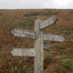



More photos from this week's walk. Near the summit of Mam Tor. Perimeter ditch to the Iron Age hill fort. Waste material from improvements to the path 🥴; Looking East along the Hope Valley towards Derwent Valley. Trig point bottom left, cement works above; @FrankWAuthor


Back in the valley, multiple choice! I'm going to the Cheshire Cheese 🍺; Hard to photograph, field showing remains of Ridge and Furrow farming;


This week's long walk, over the fields from Castleton. Mam Tor right, Treak Cliff ahead, Winnats Pass on the left. Not the best light for photos, sun and clouds. @FrankWAuthor @burngold

Extensive landslips on the North side of Rushup Edge; Second photo shows how far the debris has flowed;


A late night at the jazz club 🎼🎺? Breakfast menus on the tables when I was leaving 🤣. @FrankWAuthor @burngold


Hey @ViaGelliaRedux, from this week's walk. Is this Odin Sough, at the side of Hollowford Lane? For anyone who doesn't speak Derbyshire, drainage from Odin Mine at the foot of Mam Tor. Note the iron staining and flow measurement by weir and telemetry.

More flow measurement. The head of the valley is a small catchment, but in wet weather cave passages in a wider area will fill with water and discharge by various routes to this river. I hope that's a fair summary, if not @ViaGelliaRedux will correct me 😳!
