

Keeping A Watchful Eye On Goodhue County’s Weather. We are a group of trained severe weather storm spotters who report to the NWS Office in Chanhassen, MN.
- Tweets679
- Following120
- Followers133
- Likes32



ALT A graphic highlighting southern minnesota and western wisconsin for scattered thunderstorms. A few could be strong to severe.

ALT This graphic displays Severe Thunderstorm watch number 434 plotted on a map. The watch is in effect until 1:00 AM CDT. The watch includes parts of Iowa, Minnesota and Wisconsin. The threats associated with this watch are a couple tornadoes possible, scattered hail up to two inch size possible and scattered gusts up to 75 mph likely. There are 1,555,133 people in the watch along with 839 schools and 67 hospitals.

ALT National Weather Service severe weather outlook graphic for Minnesota and western Wisconsin on Wednesday, July 1, 2026. The map shows an Enhanced Risk (Level 3 of 5, orange) across southern Minnesota and western Wisconsin, including Minneapolis, St. Paul, Mankato, and Eau Claire. A Slight Risk (Level 2, yellow) and Marginal Risk (Level 1, dark green) extend northwest. Two rounds of storms are expected: an AM round from 5 AM to 10 AM, and a primary PM round from 6 PM to midnight bringing a threat of 70+ mph damaging winds, large hail, a few tornadoes, and flash flooding.

ALT National Weather Service severe weather outlook graphic for Minnesota and western Wisconsin on Thursday, July 2, 2026. A Slight Risk (Level 2, yellow) and Marginal Risk (Level 1, dark green) extend northwest. Primary concerns are damaging winds, large hail, a few tornadoes, and flash flooding.

ALT This graphic displays Severe Thunderstorm watch number 424 plotted on a map. The watch is in effect until 10:00 PM CDT. The watch includes parts of Minnesota and Wisconsin. The threats associated with this watch are a couple tornadoes possible, scattered hail up to two inch size possible and scattered gusts up to 70 mph possible. There are 1,698,362 people in the watch along with 709 schools and 50 hospitals.

ALT This graphic displays Severe Thunderstorm watch number 341 plotted on a map. The watch is in effect until 8:00 PM CDT. The watch includes parts of Iowa, Minnesota and Wisconsin. The threats associated with this watch are a couple tornadoes possible, scattered hail up to two inch size possible and scattered gusts up to 70 mph possible. There are 1,433,051 people in the watch along with 649 schools and 36 hospitals.

ALT Severe risk categories on the left and probabilities on the right.

ALT A map of the severe weather outlook on the left and wind risk on the right

ALT A chart of the left of temperature and on the right of heat index

ALT This graphic displays Severe Thunderstorm watch number 135 plotted on a map. The watch is in effect until 8:00 PM CDT. The watch includes parts of Minnesota and Wisconsin. The threats associated with this watch are a couple tornadoes possible, scattered hail up to ping pong size possible and scattered gusts up to 70 mph possible. There are 4,892,054 people in the watch along with 1959 schools and 96 hospitals.

ALT Lightning strikes the U.S. 25 million times a year, which sometimes results in death or permanent injury. You are safest indoors, or inside a hard-topped and enclosed vehicle. If you hear thunder or see lightning, take shelter immediately!


ALT This NOAA infographic titled "Have multiple ways to get warnings" illustrates six different methods for receiving weather alerts through a series of colorful icons. These methods include the internet, local TV and radio, wireless emergency alerts and apps, outdoor sirens, NOAA Weather Radio, and word of mouth from family, friends, or coworkers.

ALT An infographic from NOAA titled "Getting a warning could save YOUR LIFE" features a smartphone displaying six ways to receive timely weather alerts. The numbered list includes Wireless Emergency Alerts, weather apps, mobile.weather.gov, text and email services, social media, and notifications from family and friends.

ALT Thunderstorm Watch: A Severe Thunderstorm Watch is issued when severe storms are possible. Stay tuned to forecast updates and monitor sky conditions. Know where to take shelter. Thunderstorm Warning: A Severe Thunderstorm Warning is issued when a severe storm is happening or imminent. Take shelter immediately! Check for forecast updates.

ALT Key Messages Major winter storm to bring heavy snow across the region this evening through Sunday. The heaviest snow will be tonight into Sunday afternoon. Winds increase Sunday resulting in blizzard conditions across portions of southern Minnesota. Major impacts from blowing & drifting snow continue into Monday as the storm departs. A Wintry Mix will diminish amounts on the southern end of the system. High confidence in dangerous to impossible travel conditions through Sunday.

ALT Graphic showing current Watches, Warnings, and Advisories for southern Minnesota and west-central Wisconsin.

ALT Forecast matrix of snow timing and intensity for area cities.
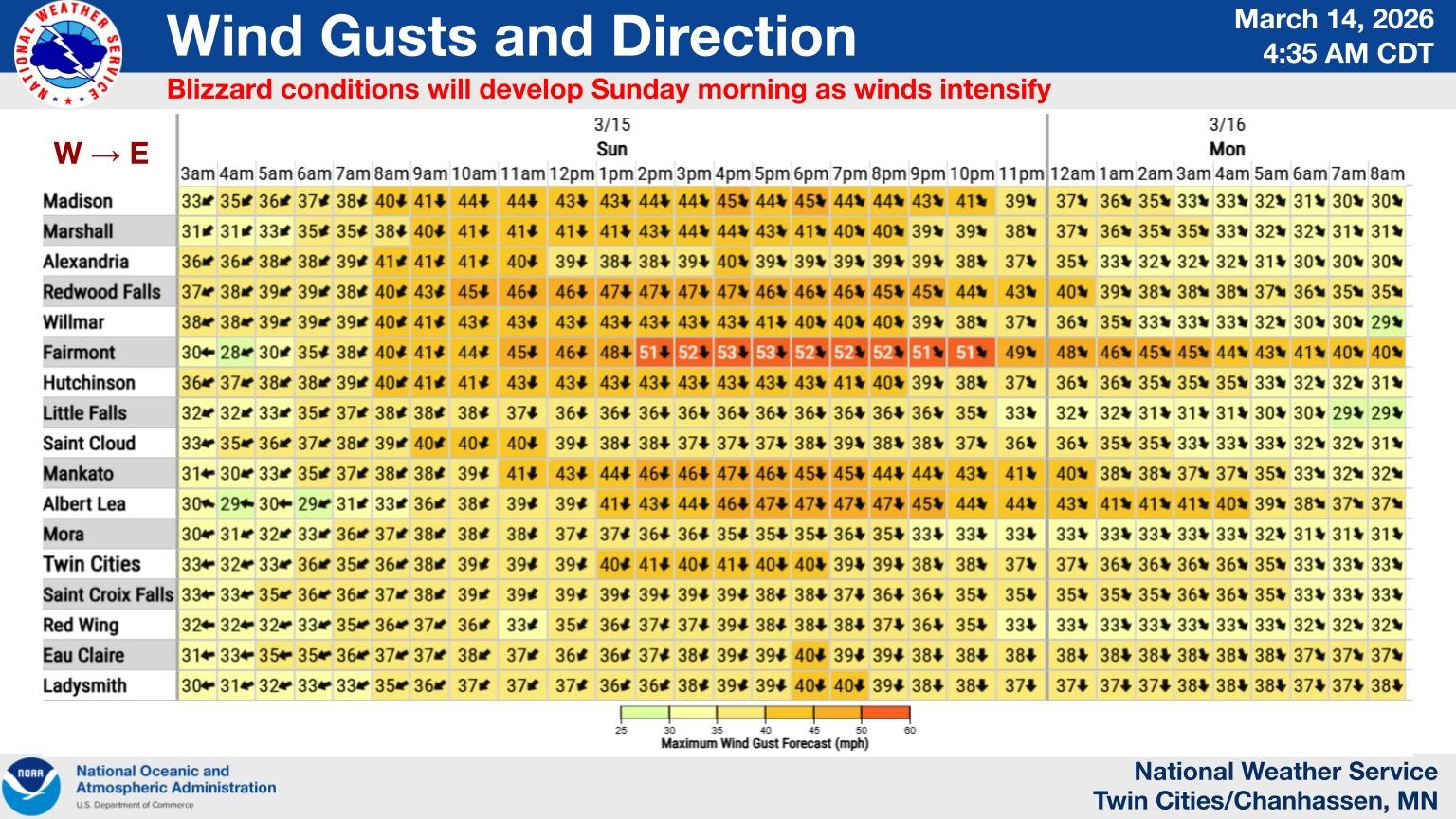
ALT Forecast matrix of hourly wind gust speed and direction for area cities.


ALT This graphic displays Severe Thunderstorm watch number 578 plotted on a map. The watch is in effect until 4:00 AM CDT. The watch includes parts of Iowa, Minnesota, South Dakota and Wisconsin. The threats associated with this watch are a couple tornadoes possible, scattered hail up to two inch size possible and scattered gusts up to 80 mph likely. There are 5,482,763 people in the watch along with 2341 schools and 161 hospitals.

ALT A map of SPC convective outlook showing a2 out of 5 slight risk across the entire region tonight from 9pm to 3am. A matrix of area cities alongside specific thunderstorm timing.


ALT A map of the storm risk for Thursday on the left with a marginal 1 out of 5 risk and Friday on the right with a slight 2 out of 5 risk.

ALT Major heat risk map across much of the area for Friday image on the right. On the left the forecast temperatures through the weekend with highs generally in the 80s and some lower 90s on Friday.

ALT Isolated chances of severe thunderstorms tonight and Wednesday. The marginal risk shifts from western Minnesota tonight to central and east Minnesota and west Wisconsin tomorrow. We gradually warm up through the week, with heat indices potentially approaching 100F for some locations by Friday.

ALT This graphic displays Severe Thunderstorm watch number 553 plotted on a map. The watch is in effect until 1:00 AM CDT. The watch includes parts of Minnesota. The threats associated with this watch are no tornadoes expected, isolated hail up to quarter size possible and scattered gusts up to 65 mph possible. There are 4,065,213 people in the watch along with 1541 schools and 67 hospitals.

