

Official Twitter account for #SantaRosaCountyEM, Florida. News and information from Santa Rosa County Emergency Management.
- Tweets4.9K
- Following249
- Followers4.6K
- Likes426




ALT Map of southeast Mississippi, southwest and south central Alabama and the western Florida panhandle showing the extent of an Excessive Heat Watch and Heat Advisory for Friday. An Excessive Heat Watch has been issued for southeast Mississippi, extreme southwestern Alabama, and a portion of the western Florida panhandle, and a Heat Advisory will be in effect for much of the remainder of the area. Heat index values up to 113 are possible in the Excessive Heat Watch area, and up to 110 in the Heat Advisory area.

ALT Map of southeast Mississippi, southwest and south central Alabama and the western Florida panhandle showing the extent of a Heat Advisory for today. A Heat Advisory is in effect for southeast Mississippi, extreme southwestern Alabama, and a portion of the western Florida panhandle. Heat index values up to 110 are possible in the Heat Advisory area.


ALT This graphic displays Severe Thunderstorm watch number 539 plotted on a map. The watch is in effect until 8:00 PM EDT. The watch includes parts of Alabama, Florida, Georgia and Mississippi. The threats associated with this watch are no tornadoes expected, isolated hail up to ping pong size possible and scattered gusts up to 70 mph possible. There are 5,141,676 people in the watch along with 1422 schools and 142 hospitals.

ALT This graphic displays a severe thunderstorm warning plotted on a map. The warning is in effect until 3:30 PM CDT. The warning includes Munson FL, Bradley AL and Cannon Town FL. This warning is for Southeastern Escambia, Northwestern Okaloosa and Northeastern Santa Rosa Counties. The threats associated with this warning are wind gusts up to 60 MPH and golf ball sized hail. There are 6,149 people in the warning along with 3 schools and 0 hospitals.

ALT This graphic displays a severe thunderstorm warning plotted on a map. The warning is in effect until 10:00 AM CDT. The warning includes Navarre FL, Wright FL and Pace FL. This warning is for Southern Okaloosa County in northwestern Florida and Southern Santa Rosa County in northwestern Florida. The threats associated with this warning are wind gusts up to 70 MPH and penny sized hail. There are 332,479 people in the warning along with 79 schools and 9 hospitals.

ALT This graphic displays a severe thunderstorm warning plotted on a map. The warning is in effect until 9:30 AM CDT. The warning includes Crestview FL, Atmore AL and Andalusia AL. This warning is for Butler County in south central Alabama, Crenshaw County in south central Alabama, Escambia County in south central Alabama, Conecuh County in south central Alabama, Covington County in south central Alabama, Northern Okaloosa County in northwestern Florida, Northern Santa Rosa County in northwestern Florida and Northwestern Escambia County in northwestern Florida. The threats associated with this warning are wind gusts up to 70 MPH and penny sized hail. There are 178,407 people in the warning along with 80 schools and 12 hospitals.

ALT This graphic displays a severe thunderstorm warning plotted on a map. The warning is in effect until 6:15 PM CDT. The warning includes Crestview FL, Munson FL and Baker FL. This warning is for Central Okaloosa County in northwestern Florida and Northeastern Santa Rosa County in northwestern Florida. The threats associated with this warning are wind gusts up to 60 MPH and quarter sized hail. There are 61,408 people in the warning along with 22 schools and 1 hospital.

ALT This graphic displays a severe thunderstorm warning plotted on a map. The warning is in effect until 5:45 PM CDT. The warning includes Crestview FL, Munson FL and Cannon Town FL. This warning is for Central Okaloosa County in northwestern Florida and Northeastern Santa Rosa County in northwestern Florida. The threats associated with this warning are wind gusts up to 60 MPH and half dollar sized hail. There are 55,404 people in the warning along with 21 schools and 1 hospital.

ALT This graphic displays a severe thunderstorm warning plotted on a map. The warning is in effect until 4:45 PM CDT. The warning includes Laurel Hill FL, Cannon Town FL and Bradley AL. This warning is for Southeastern Escambia County in south central Alabama, Southwestern Covington County in south central Alabama, Northern Okaloosa County in northwestern Florida and Northeastern Santa Rosa County in northwestern Florida. The threats associated with this warning are wind gusts up to 60 MPH and golf ball sized hail. There are 18,352 people in the warning along with 5 schools and 0 hospitals.

ALT Map of severe weather threat from now through 6 pm CDT. Several storms across Escambia and Covington Counties in Alabama continue to produce strong winds in excess of 60 mph and large hail. Some reports of hail up to tennis ball and possibly baseball sized. A tornado cannot be ruled out; however, this is still a relatively low risk. These storms will continue into the northwestern Florida Panhandle this evening and the highest confidence for severe weather will be over this area. Elsewhere, a couple severe storms could develop later this afternoon over southwestern Alabama but confidence is lower in this development. Large hail and damaging winds could be possible.

ALT This graphic displays a severe thunderstorm warning plotted on a map. The warning is in effect until 4:00 PM CDT. The warning includes Brewton AL, East Brewton AL and Riverview AL. This warning is for Eastern Escambia County in south central Alabama and Northeastern Santa Rosa County in northwestern Florida. The threats associated with this warning are wind gusts up to 60 MPH and golf ball sized hail. There are 14,639 people in the warning along with 8 schools and 1 hospital.

ALT This graphic displays Severe Thunderstorm watch number 308 plotted on a map. The watch is in effect until 9:00 PM CDT. The watch includes parts of Alabama and Florida. The threats associated with this watch are a couple tornadoes possible, scattered hail up to two inch size possible and scattered gusts up to 70 mph possible. There are 2,410,337 people in the watch along with 693 schools and 65 hospitals.

ALT This graphic displays a severe thunderstorm warning plotted on a map. The warning is in effect until 10:00 PM CDT. The warning includes Wright FL, Crestview FL and Pace FL. This warning is for East central Baldwin County in southwestern Alabama, Escambia County in south central Alabama, Southwestern Covington County in south central Alabama, Okaloosa County in northwestern Florida, Santa Rosa County in northwestern Florida and Northwestern Escambia County in northwestern Florida. The threats associated with this warning are wind gusts up to 60 MPH and pea sized hail. There are 364,393 people in the warning along with 108 schools and 10 hospitals.

ALT This graphic displays Severe Thunderstorm watch number 296 plotted on a map. The watch is in effect until 10:00 PM CDT. The watch includes parts of Alabama, Florida and Mississippi. The threats associated with this watch are a couple tornadoes possible, scattered hail up to two inch size possible and scattered gusts up to 85 mph likely. There are 2,259,310 people in the watch along with 714 schools and 76 hospitals.

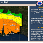
ALT Map of southeast MS, southwest AL and the western FL panhandle showing the potential for severe weather today and the timing of expected weather. Winds in excess of 70-80 mph, large hail of at least 2 inches and diameter and tornadoes possible.

ALT Map of southeast Mississippi, southwest and south central Alabama, and the western Florida Panhandle showing the potential for severe storms through 7pm this evening. The threat includes areas generally along the I-10 corridor. Main threats include damaging winds and large hail up to quarter size.

ALT This graphic displays a severe thunderstorm warning plotted on a map. The warning is in effect until 4:00 PM CDT. The warning includes Atmore AL, Century FL and Flomaton AL. This warning is for Southwestern Escambia County in south central Alabama, Northwestern Santa Rosa County in northwestern Florida and North central Escambia County in northwestern Florida. The threats associated with this warning are wind gusts up to 60 MPH and quarter sized hail. There are 27,954 people in the warning along with 16 schools and 2 hospitals.

ALT This graphic displays Severe Thunderstorm watch number 281 plotted on a map. The watch is in effect until 7:00 PM CDT. The watch includes parts of Alabama, Florida and Georgia. The threats associated with this watch are no tornadoes expected, scattered hail up to two inch size possible and scattered gusts up to 70 mph possible. There are 3,226,992 people in the watch along with 1001 schools and 105 hospitals.

ALT This graphic displays Severe Thunderstorm watch number 275 plotted on a map. The watch is in effect until 8:00 PM CDT. The watch includes parts of Alabama, Florida, Georgia and Mississippi. The threats associated with this watch are no tornadoes expected, scattered hail up to ping pong size possible and scattered gusts up to 70 mph possible. There are 2,916,794 people in the watch along with 907 schools and 92 hospitals.

ALT This graphic displays a flash flood warning plotted on a map. The warning is in effect until 3:30 PM CDT. The warning includes Ferry Pass FL, Pace FL and East Milton FL. This warning is for South Central Escambia County in northwestern Florida and Southern Santa Rosa County in northwestern Florida. Avoid walking or driving through flood waters! Move immediately to higher ground! There are 169,317 people in the warning along with 35 schools and 6 hospitals.