

Chief Meteorologist - Bluewater Broadcasting. TV and Radio Meteorologist in central Alabama for 48 years. Broadcast Seal of Approval.
Bluewater Broadcasting
Joined April 2015
- Tweets19.4K
- Following617
- Followers7.2K
- Likes3.3K




Good Morning! There’s no “Big Ticket” weather in our future through the upcoming weekend. It’s mainly a storm-free, dry forecast. Clouds will dominate much of the time. Rain chances most days 20% or less through Monday. Today, Saturday and Sunday daytime highs will be in the 70’s. There’s MUCH we don’t know about the Thanksgiving week details. But, in today’s Blog Update – we’ll tell what we do know and what we don’t know. Click below for more. Have a nice day! #alwx
richthomasweathernetwork.com…


Good Morning! The chill is still slowly fading. We’re headed for a high near 70 today. We’ll be in the lower 70’s by Friday/Saturday - and perhaps middle 70’s Sunday. It’s basically a storm-free, dry forecast for at least the next 7 Days or so. The MAIN storm system remains over the Gulf, with Florida in the line of fire. It could get a little busier in the last 6 days of this month. Details below. Here’s my brief video forecast discussion. Click below for more. Have a nice day! #alwx
richthomasweathernetwork.com…


11
547
Good Morning! The chill is slowly fading. Thankfully. We’re headed for a high of 71 today. That’s closer to normal. We’ll be in the lower 70’s on Thursday/Friday and perhaps middle 70’s by Sunday. Except for a tiny rain chance Thursday/Friday - It’s basically a storm-free, dry forecast for at least the next 7 Days or so. It could get a little busier in the last 5 days of this month. Details below. Here’s my brief video forecast discussion. Click below for more. Have a nice day! #alwx
richthomasweathernetwork.com…


13
508
Good Morning! The chill will start to fade today. We’re headed for a high of 66. Still below normal – but better. Temperatures will continue a slow recovery. We’ll be in the lower 70’s by Wednesday and Thursday and closer to the middle 70’s by Friday.Except for a tiny rain chance Friday/Saturday - It’s basically a storm-free, dry forecast for at least the next 7 Days or so. It could get a little busier in the last 5 days of this month. Click below for more. Have a nice day! #alwx


12
469
Good Morning! It’s another very chilly morning across central Alabama. A disturbance southwest of our state, in the Gulf, will continue to send a stream of high cloudiness across the area. But, it’s a dry forecast. Today’s high will sneak a little past 60. That’s still below normal – and we’re headed back to the 30’s tonight. Temperatures will start a slow recovery. We’ll be in the lower 70’s by Wednesday and closer to the middle 70’s by Thursday and Friday. It’s a storm-free, dry forecast for at least the next week. Click below for more. Have a nice day! #alwx
richthomasweathernetwork.com…


As expected, the first two freezes of the season are in the books! Just before dawn, freezing temperatures dominated most of the state deep into south Alabama. Today’s high temperature near 60°. Tonight will be another cold one. I’m expecting the Montgomery low down to 34 degrees, but some of the outlying areas could fall below freezing again. Temperatures will slowly moderate this week. I’m expecting 71° by Wednesday and 74° on Thursday and Friday. We should be dry for the next seven days. I will have a complete blog update and video discussion for you in the 4 o’clock hour tomorrow morning. Enjoy your Sunday! #alwx

15
558
It’s another Sub- freezing start this morning. Saturday morning was the first freeze of the season at MGM, with 30 degrees. This morning, the second freeze of the season. Technically, MGM got to 28.9°. More cool sunshine today with a high temperature near 60 and back to 34 tonight. #alwx
10
591
Very comprehensive summary of morning lows In the NWS Birmingham CWA -- from 24 degress up north to 34 in the lower end of the CWA. MANY, many cities and towns had their First freeze of the season -- Including 30 at Montgomery as of 5:10 this morning. FREEZE Warning again tonight. #alwx
partnerservices.nws.noaa.gov…
4
355
Rich Thomas retweeted

This map shows airline traffic during the FAA's nationwide ground stop on Nov. 13, 2026, only including aircraft types that were built for passenger service. The stop began around 3:54 p.m. ET and ended at around 8:15 p.m. ET. cbsn.ws/4iJ3rZa
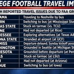
The FAA outage yesterday is making for some crazy SEC team game decisions. Here’s a partial summary. Wild stuff . Big impacts. The Ole Miss/Oklahoma game has been moved to Sunday at 12 noon Central standard time.

Due to yesterday’s massive FAA communication outage, which disrupted and canceled thousands of flights- the SEC how to make some enormous changes in the scheduling of at least nine start times of games. For instance, the Auburn game at Mississippi State was moved from 11 AM Central to 3:15 PM. The Ole Miss/Oklahoma game has been moved to Noon Sunday!
10
614
FIRST FREEZE: It's now official. Montgomery (MGM) officially fell to 30° at 5:10 this morning. FIRST freeze of the season. Last year the 1st freeze was November 10th. The Average date of the first freeze is November 18. Guess what? We'll do it again tomorrow morning. FREEZE WARNING Tonight. #alwx
1
10
642
Good Morning! It’s a COLD Saturday morning – with temperatures teetering near the freeze mark just before Dawn.
Yesterdays high did not make it out of the 50’s and I expect upper 50’s again today. There is yet another freeze warning tonight. By Sunday, Dawn it will be near or below freezing almost to the Florida border. We should see morning lows in the 30’s through perhaps Wednesday morning. Afternoon temperatures will moderate to near 71 by Wednesday.
It’s a storm-free, dry forecast for at least the next week. We may be about 9 days till the next storm system. Click below for more. Have a nice weekend! #alwx
richthomasweathernetwork.com…


6
477
The new Drought Monitor map came out yesterday. It shows 67% of the state is in a Moderate drought or greater - and 40% of the state in a SEVERE or EXTREME drought status. No rain is expected next 7-9 days. Still looks like we may be about the next storm system. Could this system produce Severe Weather? Way to early to say. #alwx


1
5
519
Good Morning! It’s the coldest air of the season. A Freeze Warning is in effect for tonight and Saturday night. Many cities and towns will see the first freeze of the season on Saturday and Sunday mornings. Today will be quite Brisk. Our expected high in the upper 50’s will feel colder due to breezy northwest winds gusting to 20-25 mph. We will be well below normal through the middle of next week. It’s a storm-free, dry forecast for at least the next week. We may be about 10 days till the next storm system. Click below for more. Have a nice day! #alwx
richthomasweathernetwork.com…


1
14
731
NWS has Issued a FREEZE WATCH for much of Alabama from Pike county northward- for Saturday morning. WATCH is issued when we are within 48 hours of the event. It will likely be upgraded to a WARNING when we get within 24 hours of the event. Many or most cities and towns may see a freeze both Saturday and Sunday AM.
* WHAT...Sub-freezing temperatures as low as 28-32 degrees.
* WHERE...A portion of central Alabama.
* WHEN...From late Friday night through Saturday morning.
* IMPACTS...Frost and freeze conditions could kill crops, other
sensitive vegetation and possibly damage unprotected outdoor
plumbing.
PRECAUTIONARY/PREPAREDNESS ACTIONS...
Take steps now to protect tender plants from the cold.
To prevent water pipes from freezing; wrap or drain or allow them to
drip slowly. #alwx
Drain in-ground sprinkler systems and cover above ground pipes.

SUPER EL NINO DECLEARED BY NOAA: Water temperatures in the Niño 3.4 region of the equatorial Pacific, where forecasters monitor the strength of El Niño, have climbed to 2.0°C above average, meeting the threshold for the designation as a Strong or Super EL Nino
THE TAKEAWAY:
NOAA announced that the 2026 El Niño has reached Super El Niño status.
Water temperatures in the Niño 3.4 region of the equatorial Pacific have climbed to 2.0°C above average for three consecutive months.
A Super El Niño will have a major impact on the 2026–2027 winter, causing more storms in the southern tier of the U.S. and above-average temperatures in the northern tier.
NOAA's Climate Prediction Center (CPC) announced Thursday that the 2026 El Niño has officially reached Super El Niño status, also known as a Very Strong El Niño.

7
582