

Somewhere talking up a storm ⛈ l 31 l TX l Meteorologist ☈ • Weather Producer @KENS5 • #UIW • @TEGNA • Questions? 📲 [email protected]
San Antonio, TX
Joined December 2011
- Tweets15.7K
- Following1.2K
- Followers2.3K
- Likes13.7K



Pinned Tweet
Life update‼️

Ryan Shoptaugh, a native of San Antonio, will appear on KENS 5’s evening weekend newscasts as well as provide weather updates on KENS 5 digital channels. kens5.com/article/entertainm…

Our coldest morning in San Antonio since early spring! Morning temperatures dropped to 46 with colder air in the Hill Country. Our coldest morning in 214 days! #txwx

Its been a fairly normal October, rain-wise. Typical rainfall for San Antonio is around 3.75" and we're more than half way there! We may see a few chances for rain into next weekend. At the moment, only widely scattered into next Saturday. #txwx

It was our coolest morning since early spring! Morning lows dropped into the 50s and 40s area wide across the region and state. Colder across West Texas. Expect a little colder, Sunday morning. Calming winds and clear skies will help with that. #txwx

Grab a sweater or jacket this weekend! The mornings will start off CHILLY and end perfect with daytime temperatures int he 60s and 70s. If you don't have plans outside, MAKE THEM! #txwx

7:25 AM - Cold front pushing south closer to Corpus Christi this morning. Temperatures still stay cool in the 60s most of today and winds gusting near 40 MPH. The front is HERE. #txwx

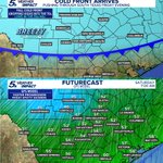
COLD FRONT FRIDAY 👀 Winds will pick up in speed Friday morning gusting near 35 MPH. Overnight temperatures will drop into the 40s and 50s, Saturday morning. Get ready! #txwx

SWEATER WEATHA 👀 Make plans to be outside Friday night and both days this weekend! Especially in the early mornings as lows fall into the 50s area wide. #txwx

Couple of things. The GFS trends this front stronger than other long-range guidance. While some of these temperatures will change in the coming days, much cooler air will move through Texas Friday night into Saturday. Around October 16-17. #txwx

These temperatures will fluctuate in the coming days, BUT signal is there for a good cold front to push through Central and South Texas, Friday into Saturday. Likely dropping highs in the 70s. Depending on strength, this could drop lows into the 50s and 40s next weekend. #txwx


The slow moving trough out west across Mexico along with a disturbance farther south will keep rain coverage and clouds around through the weekend. A 'marginal' level 1 out of 4 for localized flooding continues across our part of the state. Drive carefully! #txwx

A marginal risk for flooding remains through South and Central Texas this weekend. While rain coverage will come down, the pockets of rain that move through the region may be heavy. Daytime highs stay below normal and cooler! Stay safe! #txwx

6 PM RAIN TOTALS - Here's a look at some of the estimated rainfall amounts across the region and metro! Good soaking downpours averaging out around 1"-4" with some higher amounts. More into Friday morning. #txwx

1:20 PM - Flash flood WARNING in effect for Bexar and surrounding counties. Heavy rainfall, fast moving water may be dangerous around creeks, rivers, flood prone regions. Be careful! #txwx

9:10 AM - Showers and storms moving east, southeast this morning. Additional development to our southwest. Flood warnings in Hill Country. Cold front likely to slow down a bit on approach to I-35 providing heavy rain in the area. #txwx

The GFS pushes the front through slightly faster by the first weekend of October while the Euro slows it down. Depending on where the cold front stalls will dictate flooding concerns. That could range anywhere from I-35 to the Hill Country, Thursday and Friday. #txwx

Depending on the speed of a Pacific cold front and how it clashes with tropical moisture from the leftovers of Hurricane Polo will determine more in the coming days. As of this weekend, expect increasing rain chances and cooler temperatures into October! #txwx

Next week's cold front will be tricky. Depending on timing, this front may stall across the region which may provoke flooding concerns into late next week. Temperature drop will be small, but rain and storms will cooll us down! Stay weather aware. #txwx
