

Transforming and translating complex geo data into valuable business insights through user-friendly geospatial solutions. Reach out at [email protected].
Brown Boveri Platz 3, Baden
Joined February 2022
- Tweets248
- Following52
- Followers37
- Likes26







Pinned Tweet
Quarticle is part of the Global Top 100 Geospatial Companies 2026 (via @geoawesome_dgtl).
Grateful to be included!
#Quarticle #Geospatial #GIS #RiskManagement #SpatialAnalytics

When a flood hits, how much of your insured portfolio is exposed?
Graph by #Quarticle overlays event footprints with portfolio data to quantify insured exposure and accumulation in affected areas.
See it in action for the 2024 Valencia floods.
#Insurance #GeoIntelligence
What makes a geospatial technology company matter? The people behind it, the products they build, and the trust they earn from clients over time.
Our founder and CEO, Dr. Octavian Iercan, shares what drives #Quarticle.
Read our story: quarticle.ch/about
#GeoIntelligence

Your #GIS infrastructure should support your operations, not slow them down.
Quarticle’s cloud-native approach simplifies geospatial infrastructure, reduces operational overhead, and supports more reliable deployments.
➡️ quarticle.ch/insurance/case-…
#CloudNative #Geospatial

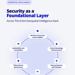
Security must be built into enterprise GeoIntelligence.
Quarticle integrates access controls, encryption, workload isolation, governance, and auditability across its geospatial stack.
Built for environments where data security and control matter.
quarticle.ch

Quarticle collaborates with technology providers, data specialists, consultants, and industry partners to bring cloud-native GeoIntelligence into enterprise workflows.
Interested in working together?
Explore our partner program: quarticle.ch/partner-program
#GeoIntelligence #GIS

What defines the way we work at #Quarticle?
Our core values shape how we collaborate, make decisions, build technology, and work with our clients.
➡️ quarticle.ch/about

What is the geospatial execution gap?
It’s the gap between proving a solution works in a pilot and making it reliable in day-to-day operations.
Our latest blog explores why geospatial projects struggle to move from pilot to production.
👉 quarticle.ch/blog/closing-th…

At #Quarticle, we build technology that connects #geospatial data with the systems, workflows, and people that depend on it.
Because the value of geospatial data isn’t in having more of it. It’s in being able to use it for your business.
Let’s talk: quarticle.ch/

What does it take to turn geospatial data into operational intelligence at enterprise scale?
At #Quarticle, we combine data, automation, expertise, and infrastructure to build production-ready #geospatial solutions.
quarticle.ch
#GeoIntelligence #Kubernetes #GIS

What does a modern #GeoIntelligence stack need?
How about scalable infrastructure that connects geospatial data, processing, and applications.
#Quarticle builds cloud-native, #Kubernetes-powered infrastructure for public, private, and hybrid environments.
Let's chat.

#Geospatial data doesn’t stand still. Datasets evolve, new sources emerge, and requirements change.
A structured workflow keeps data current, usable, and ready to support changing needs.
How well does your #data workflow adapt?
Let’s talk: quarticle.ch/contact

How quickly can you assess natural event exposure across your insurance portfolio?
With Graph, you can analyse exposure and accumulation in one geospatial environment.
quarticle.ch/products/graph
#Insurance #ExposureManagement #CatastropheRisk #Geospatial
Flood risk is often assessed at site level, but losses can occur at the building level.
In Graph by #Quarticle, assess individual structures within industrial sites and campuses against flood hazard layers across multiple return periods.
See how it works in our short video 👇
Small processing differences can change the results from the same dataset.
Quarticle builds cloud-native geospatial workflows for consistent, reliable data results.
How consistent is your data processing?
quarticle.ch/contact
#GeospatialData #GIS #LocationIntelligence

Do your data sources give you enough context for confident decisions?
The answer often lies in connecting the right layers rather than analysing each source in isolation. The Quarticle Data Hub brings data into a common geospatial foundation.
Read more: quarticle.ch/blog/building-a…

Ready to make your workflows more scalable?
GeoModel by Quarticle turns geospatial processing and delivery into reusable workflows, reducing manual work and delivering results faster.
See meteorological data become a live forecast layer in just a few clicks.
#Geospatial #GIS
How well can your systems handle high-resolution geospatial data?
At Quarticle, we process large volumes of geospatial data efficiently and at scale.
As datasets become more demanding, is your infrastructure ready?
quarticle.ch/contact
#GeospatialData #SpatialData #GIS

Turn geospatial potential into operational capability with #Quarticle Consulting.
We help organizations design and scale #GeoIntelligence solutions, from cloud-native #GIS and data integration to workflow automation.
Explore our services: quarticle.ch/consulting

How well does your data support risk-based decisions?
Connected data can reveal where risks are concentrated and how they may affect operations and planning.
Turn data into actionable risk insights.
Let's talk: quarticle.ch/contact
#GeoIntelligence #RiskManagement

New in Graph by Quarticle: Live Tropical Cyclone Forecasts
Graph brings NOAA tropical cyclone forecast data into one interactive map, including current and forecast positions, storm tracks, and forecast cones.
More on the platform: quarticle.ch/products/graph
#Geospatial #GIS