

think what you can do for the Environment and #askAdam how he can support you. Let's work together to monitor and protect our Planet 🌍
Joined September 2018
- Tweets3.5K
- Following645
- Followers8.5K
- Likes6.8K
Flash #floods have hit #Corsica, #France after 600 mm of rain fell in 3 hours in the island’s east, more than half its average annual rainfall.
The highest alert level has been issued for part of the island as rivers overflow as shows the #Copernicus #Sentinel3 image on Oct. 21.

Terrific image of the toxic haze from #Indonesia’s worst forest #fires in more than a decade in this #Copernicus #Sentinel5p CO map of Oct. 17.
89 fires are still burning across 52,940 hectares, smoke is reaching #Singapore coming also from #Papuanewguinea.
#ClimateEmergency

September 2026 was the 2nd warmest on record globally, with temperatures exceeding 1.5°C above pre-industrial levels (Era5 Data).
#Europe saw its 3rd warmest #September, while Western part tied its record at +2.51°C (highest anomaly in #Spain with +4.6°C).
#Climateemergency

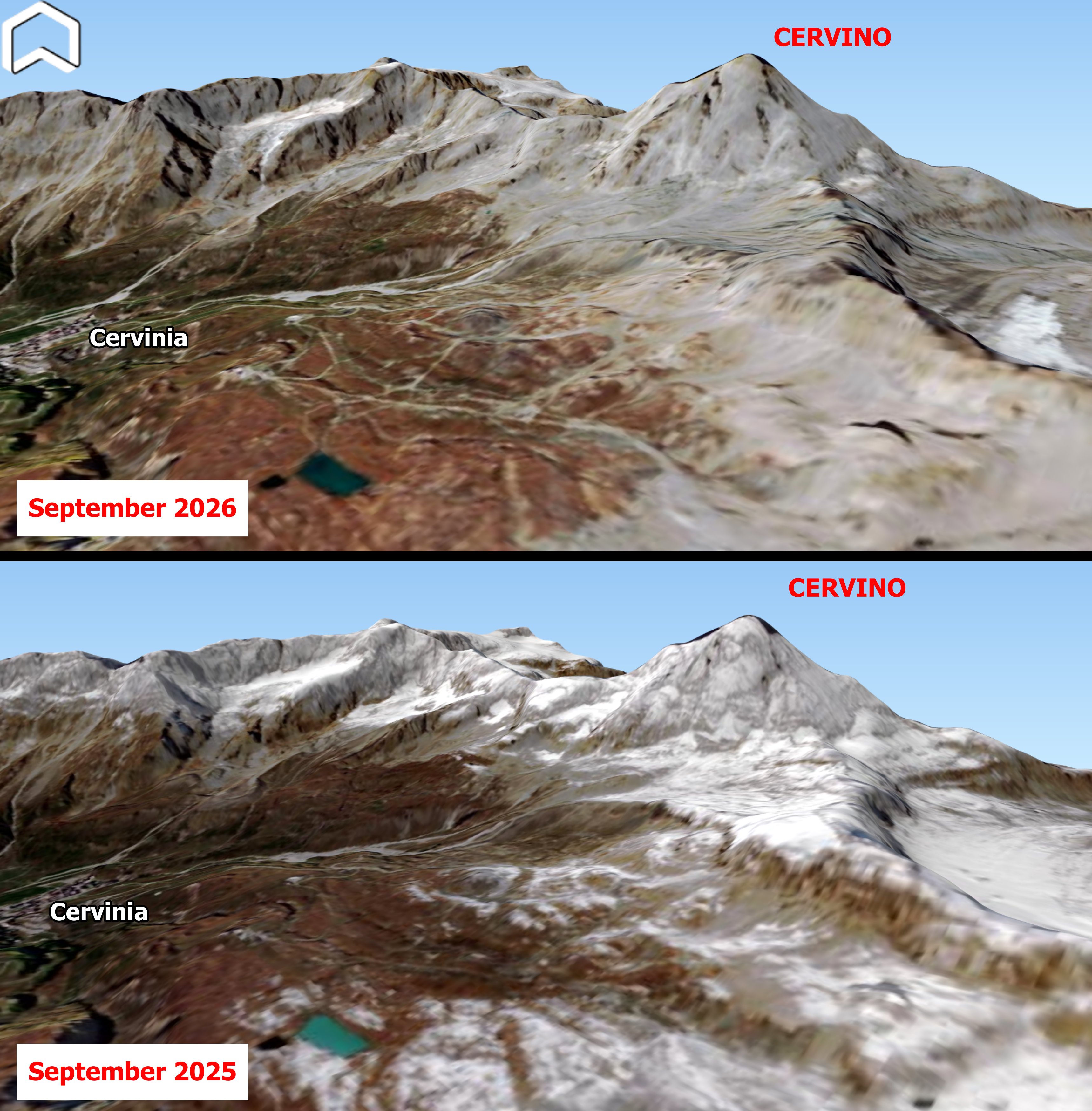
The Cervino is naked! A stunning look at the #Cervino, #Italy without snow after the scorching summer 2026 capured by #Copernicus #Sentinel2 compared with the same view from September 2025. #Alps #climateemergency #Matterhorn
@Alpenweerman
The first cloud-free image of #Krakatau #volcano and surrounding islands following the major eruption on Sep. 5 acquired by #Copernicus #Sentinel2 on Sept. 15. Volcanic activity remains unchanged, with ongoing lava effusion feeding the newly lava bench along the flank. #Indonesia

Celebrating the successful launch of #Copernicus #Sentinel3C with a stunning cloud-free view of the #IberianPeninsula some hours before the event, on Sept. 14!
A great example of the collaboration between #Sentinel3A and #Sentinel3B. #Spain #Portugal

Amazing #Copernicus #Sentinel2 image on August 11th at 9,50 UTC of #Etna shows the #eruption of the #volcano.
Explosive and effusive activity continues even from new vents. #Sicily #Italy

#Europe is burning!
Impressive @CopernicusECMWF CO Total column map of July 26 showing the CO plume generated by #wildfires in #France and #Spain.
More than 325,000 people have been evacuated, while over 42,000 hectares have burned and #smoke plume crossed the Mediterranean.

Smoke from more than 100 #wildfires burning across #Canada is affecting #airquality across #NewYork and #NewJersey.
The extent of the event is visible in the #Copernicus #Sentinel5P air quality map on July 15, highlighting the regional-scale impact of emissions. #climateemergency

Impressive #Copernicus #Sentinel2 image collected on July 13 of the #wildfire of #Fontainebleau.
More than 2,000 hectares of forest near Paris (UNESCO biosphere reserve) has been destroyed by the two fires. #climateemergency #secheresse #France
