

PDC helps organizations worldwide to enhance disaster management capacity, save lives, and reduce disaster risk with its advanced science and technology.
Kihei, HI
Joined March 2018
- Tweets2.2K
- Following605
- Followers3.1K
- Likes1K




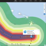
At 7 p.m. ChST on October 17 (Guam local time), dangerous Category 4 Typhoon Champi was located about 140 miles east-southeast of Guam, with maximum sustained winds of 130 mph. Champi is expected to continue strengthening as it approaches Guam.
Attached is the latest PDC Event Brief, highlighting potential impacts and exposure to damaging winds. Access critical updates and data through DisasterAWARE:
- Disaster managers and humanitarian assistance professionals can request access to DisasterAWARE Pro (disasteraware.pdc.org).
- The public can download our free Disaster Alert mobile app for updates and hazard alerts.
#SaferWorld #EarlyWarningforAll #Guam #Rota #Marianas #CNMI #Storm #TropicalStorm #Typhoon #Flood #DisasterAWARE #TyphoonChampi
@GHSOCD
@cnmihsem
@GuardGuam
@FEMA
@redcross

At 1am ChST on October 17 (local time in Guam), Tropical Storm Champi was located about 425 miles east-southeast of Guam and is expected to become a typhoon later today. Champi is currently anticipated to move over or close to Guam Sunday morning, possibly as a category 3 typhoon.
Monitor DisasterAWARE for updates with each new advisory!
- Disaster managers and humanitarian assistance professionals can request access to DisasterAWARE Pro (disasteraware.pdc.org).
- The public can download our free Disaster Alert mobile app for updates and hazard alerts.
#SaferWorld #EarlyWarningforAll #Guam #Marianas #CNMI #Storm #TropicalStorm #Typhoon #Flood #DisasterAWARE
@GHSOCD
@cnmihsem
@GuardGuam
@FEMA
@redcross
Hawaiʻi’s Pacific Disaster Center (PDC) and Samoa Launch Resilience-Building Initiative
As El Niño-driven drought and shifting weather patterns increase risks to Pacific Island communities from cyclones, fires, flooding, and other hazards, Hawaiʻi and Samoa are joining forces on a National Disaster Preparedness Baseline Assessment (NDPBA) to exchange knowledge and strengthen disaster risk reduction, preparedness, and resilience in Samoa.
As forecasters warn that El Niño could reach historic strength this year, the Government of Samoa and the University of Hawaiʻi’s Pacific Disaster Center (PDC) launched a yearlong assessment on October 14, 2026, to evaluate the island nation’s disaster risk down to the village level. Led by Samoa’s Disaster Management Office (DMO) under the Ministry of Natural Resources and Environment (MNRE), with support from the U.S. Embassy in Apia, the NDPBA kickoff drew more than 60 participants from across sectors.
“The National Disaster Preparedness Baseline Assessment provides an opportunity to bring together national data, technical assessments, institutional knowledge, and stakeholder perspectives to develop a clearer picture of our country’s disaster risk and preparedness,” said Afioga Suʻemalo Talie Foliga, Acting Chief Executive Officer of Samoa’s MNRE. “I would like to acknowledge and thank the United States through its embassy here in Samoa, as well as the team from the Pacific Disaster Center for their immense support and continued partnership.”
In his opening remarks, U.S. Chargé d’Affaires to Samoa Matthew Younger said, “Today is a monumental step forward in our journey together. We are breaking new ground with this assessment. Resilience is not built overnight, nor is it built by the government alone. It requires data, technology, community-level awareness, and above all, unwavering partnership, which we are here to offer today and to celebrate by launching the National Disaster Preparedness Baseline Assessment. Today, we are equipping Samoa’s villages, disaster managers, and leaders with the precision tools needed to anticipate threats, protect families, and safeguard Samoa’s sustainable future.”
PDC’s findings from the assessment will feed directly into DisasterAWARE, the early warning and decision-support platform used by decision-makers across the Pacific to plan, prepare for, and respond to disasters. The approach enables agencies to make immediate use of assessment data during this El Niño season rather than waiting for a final report.
Over the next year, the program will produce district-level risk profiles, an analysis of Samoa’s disaster management capabilities, and a five-year plan of action.
#Samoa #NDPBA #DisasterAWARE #SaferWorld #EarlyWarningForAll
@SamoaMNRE
@usembassysamoa
@cfedmha
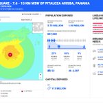
A powerful M7.6 earthquake has occurred 10km WSW of Pitaloza Arriba, Panama. Monitor DisasterAWARE for updates as this event unfolds.
Hazardous tsunami waves from this earthquake are possible within the next three hours along some coasts of Panama, Colombia, Costa Rica, Ecuador, Peru, Nicaragua, Guatemala, El Salvador and Mexico.
Attached are preliminary earthquake exposure estimates for Moderate or stronger shaking intensity, as well as tsunami travel times for those countries listed above.
Disaster managers and humanitarian assistance professionals can request access to DisasterAWARE Pro (disasteraware.pdc.org). The public can download our free Disaster Alert mobile app for updates and hazard alerts.
#Earthquake #Tsunami #Panama #Colombia #Costa Rica #Ecuador #Peru #Nicaragua #Guatemala #El Salvador #Mexico


Isaias is now a dangerous Category 3 major hurricane. See attached for more details on potential impacts, critical layers, advanced analytics, and more!
Continue to monitor DisasterAWARE and the Disaster Alert mobile app for the latest updates as this events unfolds.
Disaster managers and humanitarian assistance professionals can request access to DisasterAWARE Pro (disasteraware.pdc.org). The public can download our free Disaster Alert mobile app for updates and hazard alerts.
#hurricane #hurricaneisaias #cyclone #storm #gulfcoast #louisiana #florida #alabama #mississippi #tennessee #georgia #flood #flashflood
@gohsep
@FLSERT
@AlabamaEMA
@msema
@georgiaemahs
@tennesseeema
@USNationalGuard
@redcross
Isaias has intensified into a hurricane in the central Gulf. Isaias is forecast to continue strengthening into a Category 2 hurricane later tonight before reaching the northern Gulf Coast late Friday into early Saturday.
A life-threatening storm surge is expected from the Mouth of the Mississippi River to Suwannee, Florida. Damaging hurricane force-winds are expected over portions of the Florida Panhandle, southern Alabama, and southern Mississippi where a Hurricane Warning is in effect. Damaging wind gusts are possible over much of central and northern Alabama and portions of western and northern Georgia, especially in areas of higher terrain. Isaias will bring heavy rainfall to the central U.S. Gulf coast and much of the Southeast Friday into the weekend. Considerable flash and urban flooding, along with significant river flooding, will be possible.
Get the full picture at DisasterAWARE.pdc.org—including updates and alerts, potential impacts (e.g. wind, rainfall, storm surge), exposure analytics, critical infrastructure, live cameras, and more!
Disaster managers and humanitarian assistance professionals can request access to DisasterAWARE Pro (disasteraware.pdc.org). The public can download our free Disaster Alert mobile app for updates and hazard alerts.
#hurricane #tropicalstormisaias #cyclone #storm #gulfcoast #louisiana #florida #alabma #mississippi #flood #flashflood
@gohsep
@FLSERT
@AlabamaEMA
@msema
@USNationalGuard
@RedCross
@fema


Tropical Storm Isaias is currently located in the southern Gulf near the Yucatan of Mexico. Isaias is forecast to rapidly strengthen over the next few days into a Category 2 hurricane before reaching the northern Gulf Coast by the end of week.
There is a high risk of dangerous wind and storm surge impacts along portions of the northern Gulf Coast from Louisiana to the Florida Panhandle. Hurricane and Storm Surge Watches have been issued for portions of the northern Gulf coast. Tropical Storm Isaias will bring heavy rainfall to the central U.S. Gulf coast and much of the Southeast Friday into the weekend. Flash and urban flooding, along with isolated river flooding, will be possible.
Get the full picture at DisasterAWARE.pdc.org—including updates and alerts, potential impacts (e.g. wind, rainfall, storm surge), exposure analytics, critical infrastructure, live cameras, and more!
Disaster managers and humanitarian assistance professionals can request access to DisasterAWARE Pro (disasteraware.pdc.org). The public can download our free Disaster Alert mobile app for updates and hazard alerts.
#cyclone #storm #tropicalstorm #gulfcoast #louisiana #florida #alabma #mississippi #flood #flashflood #hurricane #tropicalstormisaias
@gohsep
@FLSERT
@AlabamaEMA
@msema
@USNationalGuard
@redcross


Sending aloha and a big mahalo (thank you) to our long-time partners at the Philippines Office of Civil Defense (OCD)! The team was excited to be back in Manila recently to upgrade PhilAWARE and provide advanced administration training. We also commend OCD for its continued commitment to leveraging the latest technology and data to strengthen early warning, preparedness, and resilience across the region.
PhilAWARE serves as a mission-critical tool within OCD's Emergency Operations Center (EOC) for hazard early warning and decision support. These enhancements and training efforts reflect our ongoing collaboration with OCD and help ensure continued access to real-time situational awareness, advanced analytics, hazard information and alerts, and actionable risk insights. Together, these capabilities support informed decision-making, resource prioritization, and coordinated disaster planning and response when it matters most.
PhilAWARE is part of PDC’s advanced DisasterAWARE ecosystem and a custom version created for the Philippines. Learn more!
DisasterAWARE: pdc.org/disasteraware/
PhilAWARE in action: pdc.org/empowering-readiness…
#SaferWorld #EarlyWarningforAll #Philippines #Manila #PhilAWARE #DisasterAWARE #EarlyWarning #Preparedness #Hazard #DisasterPrepareness
@civildefensePH
Nolo remains a Category 2 hurricane and is currently located about 145 miles south of South Point Hawaii. Forecasts indicate that Nolo is expected to remain south of the Big Island of Hawaii today before turning westward and moving away from the island. Tropical storm conditions are occurring on the Big Island, especially in areas of steep terrain, and hurricane conditions are possible in those areas today. Heavy rain is expected to expand across the Big Island and eastern Maui through the weekend.
Significant, life-threatening flooding and mudslides are possible, especially in areas of steep terrain across the eastern and southern portions of the Big Island and Maui. Lesser rainfall totals are expected across the rest of Hawaii. Large and damaging waves are likely along portions of the Big Island's coastline this weekend.
Continue to monitor DisasterAWARE for updates as Hurricane Nolo progresses.
Disaster managers and humanitarian assistance professionals can request access to DisasterAWARE Pro (disasteraware.pdc.org).
The public can download our free Disaster Alert mobile app for updates and hazard alerts.
#disasteralert #earlywarningforall #saferworld #hawaii #BigIsland #Maui #Molokai #Lanai #Oahu #Kauai #hurricanenolo #hurricane
@Hawaii_EMA
@Maui_EMA
@CivilDefenseHI
@Oahu_DEM
@hawaiiredcross


As Hawai‘i continues to recover from the recent impacts of Hurricanes Lala and Lowell, Hurricane Nolo is moving toward the Big Island of Hawai‘i as a Category 2 Hurricane. PDC continues to offer disaster managers the latest impact analysis and key information about the status of critical infrastructure and recovery across Hawai‘i through its DisasterAWARE Pro platform
The public can access all the latest updates on our free Disaster Alert mobile app and is encouraged to check the 6-hour updates from the Central Pacific Hurricane Center available on the app as uncertainty remains about the track and impacts of Nolo.
#HurricaneNolo #disasteraware #DisasterAlert #Hawaii #maui #bigisland #EarlyWarningForAll
@Hawaii_EMA
@Maui_EMA
@CivilDefenseHI
@Oahu_DEM
@hawaiiredcross
Hurricane Nolo is currently located about 220 miles south of South Point Hawaii. Forecasts indicate that Nolo is expected to remain south of the Big Island through Saturday before turning westward and moving away from the island. Tropical storm conditions are expected to begin on the Big Island Friday night with hurricane conditions possible on Saturday, particularly in areas of steep terrain. Heavy rain increases in both coverage and intensity on Friday and will continue across the Big Island and Maui through the weekend.
Life-threatening, catastrophic flooding and mudslides are possible, especially in areas of steep terrain across the eastern and southern portions of the Big Island and Maui. Across the remainder of Hawaii, lesser rainfall totals are expected, with isolated flooding possible. Large and damaging waves are likely along portions of the Big Island's coastline into the weekend.
Continue to monitor DisasterAWARE for updates as Hurricane Nolo progresses.
Disaster managers and humanitarian assistance professionals can request access to DisasterAWARE Pro (disasteraware.pdc.org).
The public can download our free Disaster Alert mobile app for updates and hazard alerts.
#disasteralert #earlywarningforall #saferworld #hawaii #BigIsland #Maui #Molokai #Lanai #Oahu #Kauai #hurricanenolo #hurricane
@Hawaii_EMA
@Maui_EMA
@CivilDefenseHI
@Oahu_DEM
@hawaiiredcross


A powerful Nor’easter will impact the Eastern United States this weekend. A strong coastal low over western Atlantic will continue to intensify by late week and will bring strong onshore flow across the Mid-Atlantic northward into the New England by the weekend. Rain will become heavier and more persistent by late Friday into early Saturday. Several days of rainfall could produce locally high rainfall totals, particularly across southern New England and eastern Massachusetts. Impacts will include wind gusts will be in excess of 45 mph, moderate to major coastal flooding, high surf, rip currents, and beach erosion.
Monitor DisasterAWARE Pro and the Disaster Alert app for updates and alerts!
>>> Are you a Disaster Manager? Access DisasterAWARE Pro at DisasterAWARE.pdc.org—including live cameras, animated forecasts, advanced analytics and more!
>>> Download the free Disaster Alert app, available on Google Play and the iOS App Store (Search "Disaster Alert" in the app stores)
#SaferWorld #EarlyWarningforAll #DisasterAWARE #Nor’easter #Weather #Flood #Wind #NewYork #NewJersey #RhodeIsland #Maryland #Delaware #CapeCod #Connecticut #Massachusets #Maine
@American Red Cross
@National Guard Bureau
@fema
@Team Rubicon
@Massachusetts Emergency Management Agency (MEMA)
@NYS Division of Homeland Security & Emergency Services
@New York City Emergency Management Department
@CT Department of Emergency Services and Public Protection

As of 11:00 AM HST, Hurricane Lowell remains a powerful Category 3 hurricane, with maximum sustained winds of 120 mph, located approximately 545 miles south-southwest of Līhuʻe and moving north at approximately 6 mph. PDC wind impacts and storm surge estimates are below.
Lowell is expected to remain a hurricane as it passes just west of the main Hawaiian Islands, with its center forecast to pass just west of Kauaʻi County late Monday into early Tuesday. Tropical-storm-force winds extend up to 175 miles from the center, allowing impacts to occur well away from the storm's core. A Tropical Storm Warning remains in effect for Kauaʻi County, with hurricane-force wind gusts possible over elevated terrain. Gradual weakening is forecast to begin tonight.
Potentially significant impacts include heavy rainfall and flash flooding, dangerous surf and coastal flooding, and tropical-storm-force winds, particularly across Kauaʻi and Niʻihau Monday through Tuesday morning. Kauaʻi could receive 6–10 inches of rainfall, with isolated totals up to 14 inches, with flash flooding and mudslides possible. Storm surge of 1–3 feet is possible in Kauaʻi County, and life-threatening surf and rip current conditions are expected across many of the Hawaiian Islands during the next several days.
Disaster management decision-makers can view Hawai'i DFIRM Flood Zones: disasteraware.pdc.org/?bookm…
and Hawai'i Storm Surge Risk at disasteraware.pdc.org/?bookm… through DisasterAWARE.
#Disasteraware #EarlyWarningForAll #SaferWorld #HurricaneLowell
@CivilDefenseHI
@Hawaii_EMA
@CountyofKaui
@NationalGuard

